Exploring the Petelinje–Ilirska Bistrica Road: A Motorcyclist’s Guide Through Brkini and the Pivka Lakes Park
Locals know best!
If you travel this road often or live close by you will be given a chance to provide your valuable rating soon! Sign in and stay connected.Location and Overview of the Petelinje–Ilirska Bistrica Road
The Petelinje–Ilirska Bistrica road is situated in southwestern Slovenia, connecting the village of Petelinje with the town of Ilirska Bistrica. The route traverses the Brkini region, an area known for its rolling hills and rural landscapes. Along the way, the road passes through several settlements, including Knežak, Snežniška cesta, Zagorje, and Šembije. The road also intersects the Krajinski park Pivška presihajoča jezera, a protected area famous for its intermittent lakes. An interactive map showing the full route can be found at the end of this article.
Road Characteristics and Riding Experience
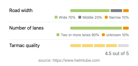
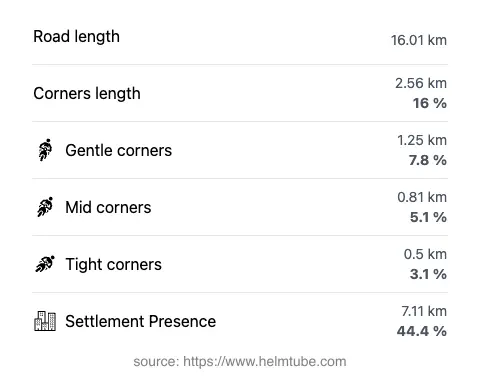
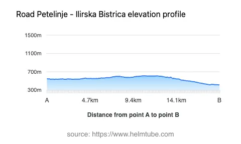
This road extends for approximately 16 km (9.9 miles), with the majority (about 91%) consisting of two lanes, providing ample space for overtaking and comfortable riding. The surface is asphalt and is generally rated as very good, offering a smooth ride for most motorcycles. The road is not particularly twisty, featuring gently curved sections that allow for a relaxed pace, though some bends require attention. The width is predominantly wide (about 69%), with some stretches narrowing, especially near settlements. Elevation ranges from 415 m (1,362 ft) at its lowest point to 613 m (2,011 ft) at its highest, resulting in mild elevation changes suitable for riders of all skill levels. Speed limits vary along the route, with posted limits of 40, 50, 70, and 90 km/h (25, 31, 43, and 56 mph) depending on the section and proximity to inhabited areas.
Natural Attractions and Points of Interest
One of the highlights of this route is its passage through the Krajinski park Pivška presihajoča jezera, a landscape park renowned for its intermittent lakes, which appear and disappear with the seasons. These lakes are a unique hydrological phenomenon in Slovenia and attract visitors interested in nature and geology. The road also runs adjacent to the Pivka River for a portion of its length, offering occasional views of the watercourse as it makes its way toward the famous Postojna Cave. The Brkini region itself is characterized by orchards, meadows, and traditional rural settlements, providing a glimpse into the local way of life. Riders may wish to stop in the town of Ilirska Bistrica, which serves as a gateway to further exploration of southwestern Slovenia.
Road Closures, Seasonal Access, and Regulations
There are currently no known restrictions specifically prohibiting motorcycles on the Petelinje–Ilirska Bistrica road. The route is a public road and remains open throughout the year, though riders should be aware that winter conditions may affect surface quality and traction, particularly in colder months. Temporary closures may occur due to roadworks or local events, so it is advisable to check with the Slovenian Traffic Information Center before departure for the latest updates on road conditions and closures.
Tolls, Fees, and Practical Information
There are no tolls or entrance fees required to ride the Petelinje–Ilirska Bistrica road. However, as the route passes through a protected landscape park, riders are encouraged to respect local regulations and preserve the natural environment. Toll conditions and regulations may change in the future, so for the most current information on road tolls and fees in Slovenia, consult the DARS vignette information page. Facilities along the route are limited, so it is recommended to refuel and stock up on supplies in larger settlements such as Ilirska Bistrica before setting out.
Explore the Region: Roads Close By
Discover more amazing roads located near the route featured in this article. The list below highlights nearby routes that are perfect for extending your ride or planning your next adventure.
Ride the Best: Slovenia’s Top Motorcycle Roads
These are the best motorbiking roads in Slovenia. The list below shows links to articles about top-rated motorcycle routes in the country. Explore the most popular roads in Slovenia and plan your next unforgettable motorbike adventure.