Exploring the 643 Preserje–Rakitna–Cerknica Route: A Technical Overview for Motorcyclists
Locals know best!
If you travel this road often or live close by you will be given a chance to provide your valuable rating soon! Sign in and stay connected.Location and Route Overview
The 643 Preserje–Rakitna–Cerknica road is situated in central Slovenia, running between the settlements of Preserje and Cerknica. The route passes through a series of smaller villages, including Begunje pri Cerknici, Podpeč, Selšček, Pikovnik, and Kržišče. The road is positioned within a region characterized by rolling hills and forested areas, with the Cerkniščica river running adjacent to a portion of the route. The starting point is near the town of Vrhnika, approximately 8.9 km (5.5 miles) away, while the endpoint is close to Cerknica, just 388 meters (1,273 ft) from the town center. An interactive map showing the road can be found at the end of the article.
Technical Road Details
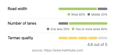
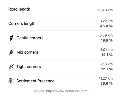
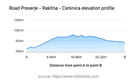
The 643 Preserje–Rakitna–Cerknica route extends for approximately 28.5 km (17.7 miles), offering a moderately twisty ride. The road features a mix of gently curved and more pronounced bends, making it suitable for riders seeking a balanced experience between straight sections and curves. The surface is asphalt and is generally rated as very good, providing a smooth ride for most motorcycles. The majority of the road is two lanes wide (about 79%), with a smaller portion consisting of a single lane. In terms of width, most of the route is considered wide (about 75%), with some middle-width and narrow sections. The elevation ranges from 290 m (951 ft) at its lowest point to 890 m (2,920 ft) at its highest, offering some elevation changes but without extreme gradients. Approximately 39.6% of the road passes through inhabited areas, so riders should be mindful of local traffic and potential pedestrian activity.
Natural Features and Points of Interest
One notable natural feature along the route is the Cerkniščica river, which runs adjacent to about 8% of the road. The river and surrounding landscape contribute to the region's appeal for outdoor enthusiasts. The road also provides access to the village of Rakitna, known for its proximity to the Rakitna Lake, a popular local destination for relaxation and recreation. The endpoint near Cerknica offers the opportunity to visit the Lake Cerknica, a unique intermittent lake and a well-known natural phenomenon in Slovenia. These attractions are uniquely tied to the area and can be incorporated into a day trip or longer tour.
Road Closures and Seasonal Considerations
There are no permanent closures for motorcycles on the 643 Preserje–Rakitna–Cerknica road. However, as with many roads in Slovenia that traverse higher elevations, temporary closures may occur during winter months due to snow or adverse weather conditions, particularly in the Rakitna area. Riders are advised to check local traffic updates or the Slovenian Traffic Information Center for current road status before planning a trip, especially outside the main riding season. No regular event-related closures have been reported for this route.
Tolls, Fees, and Practical Information
The 643 Preserje–Rakitna–Cerknica road does not currently require a toll or entrance fee for motorcycles. Riders should note that toll conditions may change in the future, and it is advisable to verify the latest information before travel. For comprehensive details on road tolls and vignettes in Slovenia, consult the official DARS website. Fuel stations and basic amenities are available in the larger towns near the route, such as Vrhnika and Cerknica, but options are limited along the more rural sections. Riders should plan accordingly for fuel and refreshments.
Explore the Region: Roads Close By
Discover more amazing roads located near the route featured in this article. The list below highlights nearby routes that are perfect for extending your ride or planning your next adventure.
Ride the Best: Slovenia’s Top Motorcycle Roads
These are the best motorbiking roads in Slovenia. The list below shows links to articles about top-rated motorcycle routes in the country. Explore the most popular roads in Slovenia and plan your next unforgettable motorbike adventure.