Adriatic Route - Jadranska Magistrala - Velebit Coastal Route
Locals know best!
If you travel this road often or live close by you will be given a chance to provide your valuable rating soon! Sign in and stay connected.Location and Geographic Context
This road segment is situated in Croatia, running parallel to the Adriatic Sea and intersecting the Velebit Nature Park. The route begins near Naselje bana Josipa Jelačića and extends to Ulica dr. Franje Tuđmana, passing through settlements such as Lukovo Šugarje, Dražica, Gradina, Lisarica, and Tribanj-Mandalina. The road is part of the broader Jadranska magistrala (Adriatic Highway), a well-known coastal artery. Its proximity to the Velebit mountain range and the bay of Uvala Lukovo Šugarje makes it a notable choice for riders seeking both coastal and mountainous scenery. An interactive map showing the road can be found at the end of the article.
Road Characteristics and Riding Experience
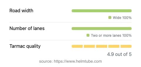
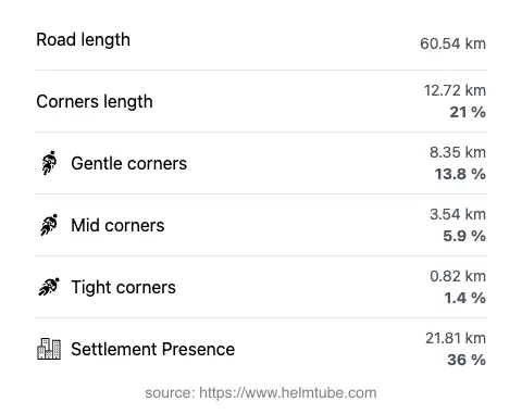
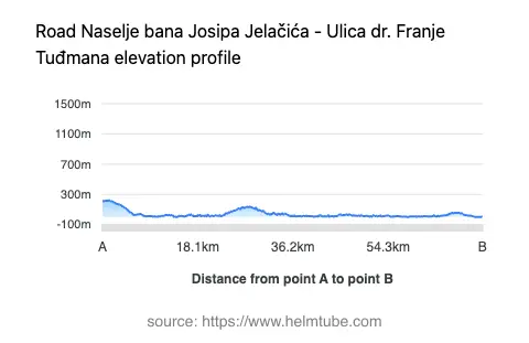
The Naselje bana Josipa Jelačića – Ulica dr. Franje Tuđmana route covers approximately 60.5 km (37.6 miles), with the majority of the road being wide (about 99%) and featuring two lanes (about 97%). The surface is asphalt and is generally rated as excellent, providing a smooth riding experience. The road is moderately curvy, offering a mix of gently curved and straight sections, suitable for riders of varying skill levels. Elevation ranges from sea level (0 m / 0 ft) to 223 m (732 ft), allowing for occasional panoramic views, especially near the Velebit slopes and the coastline. Speed limits vary along the route, typically ranging from 30 km/h (19 mph) in inhabited areas to 90 km/h (56 mph) in open stretches. Approximately 36% of the route passes through inhabited areas, so riders should be mindful of local traffic and pedestrian activity.
Natural Attractions and Points of Interest
This road is notable for its passage through Velebit Nature Park, a protected area recognized for its biodiversity and dramatic karst landscapes. The proximity to the bay of Uvala Lukovo Šugarje offers occasional glimpses of the Adriatic coastline, particularly in sections where the road nears the sea. Riders will also encounter several viewpoints along the route, providing opportunities to stop and appreciate the surrounding vistas. The settlements along the way, such as Lukovo Šugarje and Tribanj-Mandalina, offer a glimpse into local coastal life and may serve as convenient rest stops.
Seasonal Closures, Road Access, and Fees
The Naselje bana Josipa Jelačića – Ulica dr. Franje Tuđmana route is generally open year-round and accessible to motorcycles. However, weather conditions, particularly strong winds (bura) and occasional winter storms, can lead to temporary closures or restrictions, especially on exposed coastal sections. There are no dedicated tolls or entrance fees for this road segment, but riders should be aware that conditions may change in the future. For up-to-date information on road tolls and entrance fees in Croatia, consult the Croatian Automobile Club (HAK) website. Event-related closures are rare but may occur during local festivals or maintenance works.
Practical Considerations for Motorcyclists
Riders should be prepared for variable weather, especially in the Velebit region where sudden changes are common. The excellent road surface supports comfortable riding, but caution is advised in inhabited areas and during adverse weather. Fuel stations and services are available in larger settlements, but planning ahead is recommended due to the rural nature of some stretches. The route’s combination of coastal and mountainous environments makes it a rewarding choice for those seeking a diverse motorcycling experience along the Croatian Adriatic. For further details on the Velebit Nature Park, visit the official park website.
Explore the Region: Roads Close By
Discover more amazing roads located near the route featured in this article. The list below highlights nearby routes that are perfect for extending your ride or planning your next adventure.
Ride the Best: Croatia’s Top Motorcycle Roads
These are the best motorbiking roads in Croatia. The list below shows links to articles about top-rated motorcycle routes in the country. Explore the most popular roads in Croatia and plan your next unforgettable motorbike adventure.