Arlberg Pass (Arlbergpass) - B197: A Technical Overview for Motorcyclists
Locals know best!
If you travel this road often or live close by you will be given a chance to provide your valuable rating soon! Sign in and stay connected.Location and Geographic Context
The Arlberg Pass (Arlbergpass) - B197 is situated in western Austria, running through the state of Vorarlberg. The road connects the town of Bludenz at its western approach to the village of Langen am Arlberg at its eastern end. The route follows the Klostertal valley, closely paralleling the Alfenz river for much of its length. The pass is positioned within the broader context of the Alps, intersecting both the Lechquellengebirge and Verwallgruppe mountain ranges. This strategic location makes the B197 a key transit route for both local and long-distance traffic. An interactive map showing the precise route of the Arlberg Pass (Arlbergpass) - B197 can be found at the end of this article.

Road Characteristics and Riding Experience
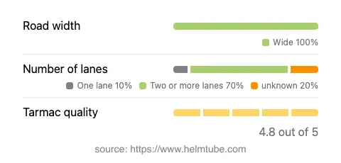
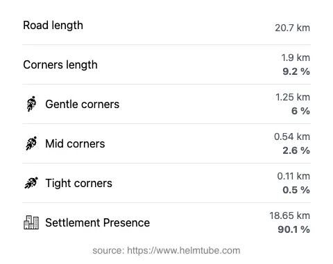
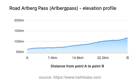
The Arlberg Pass (Arlbergpass) - B197 extends for approximately 20.7 km (12.9 miles), offering a predominantly wide carriageway (about 100% of its length) with two lanes for the majority of the route (about 69%). The road surface is asphalt and is generally rated as excellent, providing a smooth and predictable riding experience. The route is not particularly twisty, with gentle curves dominating the alignment, making it suitable for riders who prefer less technical riding. The elevation ranges from 627 m (2,057 ft) at its lowest point to 1,163 m (3,816 ft) at its highest, ensuring moderate altitude changes without extreme gradients. The B197 passes through several settlements, including Arlbergstraße, Klostertalerstraße, Oberbings, Oberradin, Großtobel-Galerie, Gasteltobeltunnel, and Klostertaler Straße, with approximately 90% of the road traversing inhabited areas. The maximum speed limits vary along the route, with sections posted at 50 km/h (31 mph), 60 km/h (37 mph), and 100 km/h (62 mph), depending on proximity to settlements and road conditions.


Seasonal Accessibility and Road Closures
The Arlberg Pass (Arlbergpass) - B197 is generally open to motorcycles throughout the year. However, due to its alpine location, temporary closures can occur during periods of heavy snowfall or adverse weather, particularly in winter months. The pass is not subject to a fixed seasonal closure, but riders should be aware that conditions can change rapidly in the Alps. It is advisable to check current road status before planning a journey, especially outside the summer season. Information on current road conditions and potential closures can be found on the ASFINAG Traffic Reports website.
Tolls, Fees, and Regulations
There is no toll or entrance fee required for motorcycles using the Arlberg Pass (Arlbergpass) - B197. However, toll conditions may change in the future, and it is recommended to verify the latest information before travel. For up-to-date details on tolls and vignettes for Austrian roads, including any changes affecting the B197, consult the ASFINAG Toll and Vignette page. Riders should also be aware of general Austrian traffic regulations, including mandatory use of headlights during the day and the requirement for appropriate protective gear.
Natural Features and Points of Interest
The B197 closely follows the Alfenz river for nearly 80% of its length, providing a consistent natural backdrop. The road traverses the Klostertal valley, a notable geographic feature of the region. The surrounding mountain ranges, including the Alps, Lechquellengebirge, and Verwallgruppe, frame the route and contribute to its alpine character. The nearby town of Bludenz serves as a convenient starting point, offering amenities and accommodation for travelers. At the eastern end, the village of Langen am Arlberg provides access to further alpine destinations. For those interested in exploring the local geography, the Klostertal valley is documented in detail on Wikipedia.
Explore the Region: Roads Close By
Discover more amazing roads located near the route featured in this article. The list below highlights nearby routes that are perfect for extending your ride or planning your next adventure.
Ride the Best: Austria’s Top Motorcycle Roads
These are the best motorbiking roads in Austria. The list below shows links to articles about top-rated motorcycle routes in the country. Explore the most popular roads in Austria and plan your next unforgettable motorbike adventure.