Hahntennjoch (Hahntennjoch): A Technical Overview for Motorcyclists
Locals know best!
If you travel this road often or live close by you will be given a chance to provide your valuable rating soon! Sign in and stay connected.Location and Geographic Context
The Hahntennjoch (Hahntennjoch) is situated in the Austrian Alps, connecting the village of Boden with the town of Imst in the state of Tyrol. The road traverses the Lechtal Alps, a subrange of the Northern Limestone Alps, and crosses the Hahntennjoch mountain pass at an elevation of 1,894 m (6,214 ft). The route primarily follows the Hahntennental valley, with a significant portion also adjacent to the Fundaistal valley. The surrounding landscape is characterized by rugged alpine terrain and steep slopes, typical of the Lechtal Alps. An interactive map showing the precise route of the Hahntennjoch can be found at the end of this article.
Road Characteristics and Riding Experience
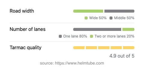
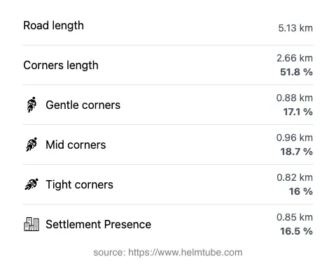
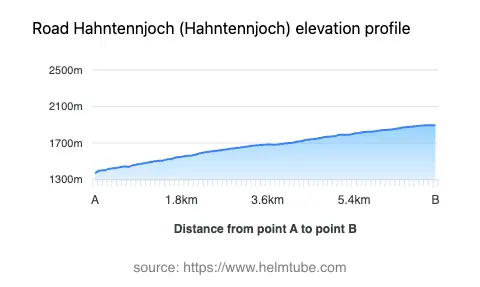
The Hahntennjoch road extends for approximately 5.1 km (3.2 miles), with the majority of its length featuring a very twisty alignment. The surface is asphalt and is generally rated as excellent, providing a high level of grip and comfort for motorcyclists. The road width alternates between medium and wide, with about half of the route offering ample space for maneuvering. Most of the road consists of a single lane in each direction (about 75%), with some sections expanding to two lanes (about 17%). The route is predominantly outside inhabited areas, with only a small proportion (16.5%) passing through settlements. The elevation ranges from 1,377 m (4,518 ft) at its lowest point to 1,895 m (6,217 ft) at its highest, offering significant altitude variation over a relatively short distance. The maximum permitted speed varies between 60 km/h (37 mph) and 30 km/h (19 mph), depending on the section and prevailing conditions.
Seasonal Closures and Access Restrictions
The Hahntennjoch is subject to seasonal closures, typically being closed to all traffic, including motorcycles, during the winter months due to snow and avalanche risk. The exact dates of closure can vary depending on weather conditions but generally extend from late autumn to late spring. There may also be temporary closures for maintenance or due to adverse weather events such as rockfalls or heavy rainfall. Motorcyclists are advised to check current road status before planning a trip, as access can change at short notice. Up-to-date information is available from the Tirol road authority.
Tolls, Fees, and Regulations
Currently, there is no toll or entrance fee required to ride the Hahntennjoch (Hahntennjoch). However, toll conditions may change in the future, and riders are encouraged to verify the latest information before their journey. For comprehensive details on road tolls and entrance fees in Austria, consult the official ASFINAG toll information website. Standard Austrian traffic regulations apply, including speed limits and requirements for protective gear. Due to the road’s alpine nature and variable weather, it is advisable to check for any additional restrictions or advisories, especially during periods of increased risk such as heavy rainfall or after snowfall.
Points of Interest and Surrounding Attractions
The Hahntennjoch (Hahntennjoch) passes through the heart of the Lechtal Alps, offering access to a range of alpine environments. The nearby village of Boden and the town of Imst serve as convenient starting and ending points, both providing essential services for travelers. The region is also known for its hiking trails and mountain scenery, with the Hahntennental and Fundaistal valleys offering opportunities for exploration. For those interested in the broader alpine context, the road is part of the extensive Alps mountain system, which is renowned for its geological diversity and outdoor recreation options. Riders seeking further information on the area’s attractions may consult resources such as Tripadvisor: Imst.
Explore the Region: Roads Close By
Discover more amazing roads located near the route featured in this article. The list below highlights nearby routes that are perfect for extending your ride or planning your next adventure.
Ride the Best: Austria’s Top Motorcycle Roads
These are the best motorbiking roads in Austria. The list below shows links to articles about top-rated motorcycle routes in the country. Explore the most popular roads in Austria and plan your next unforgettable motorbike adventure.