Exploring the Boljunčica Valley Route: Županijska cesta 5046 for Motorcyclists
Locals know best!
If you travel this road often or live close by you will be given a chance to provide your valuable rating soon! Sign in and stay connected.Location and Regional Context
Županijska cesta 5046 is situated in the Istria region of Croatia, connecting the settlements of Cerovlje and Brus. The route lies northeast of the town of Pazin, which is approximately 3.8 km (2.4 miles) from the road’s starting point. The road runs parallel to the Boljunčica River for a short segment, offering occasional views of the valley. The surrounding area is characterized by rolling hills, agricultural land, and small villages, providing a distinctly rural Istrian atmosphere. An interactive map showing the precise route of Županijska cesta 5046 can be found at the end of this article.
Technical Road Details
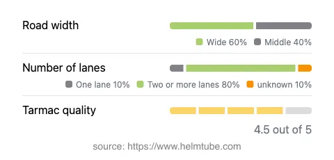
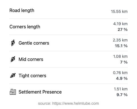
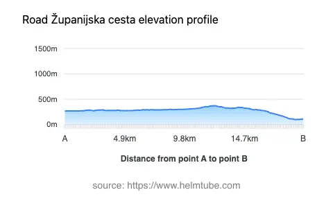
Županijska cesta 5046 extends for approximately 15.6 km (9.7 miles), with the majority of the road featuring two lanes (about 80%) and a wide carriageway (about 60%). The surface is asphalt and is generally rated as very good, offering a smooth ride for most motorcycles. The road’s elevation ranges from 100 m (328 ft) to 373 m (1,224 ft), with gentle undulations rather than steep climbs. The route is moderately curvy, providing a mix of gently curved and straight sections, suitable for riders seeking a relaxed yet engaging ride. Only a small portion (about 9.7%) passes through inhabited areas, minimizing urban traffic interruptions. The maximum speed limits vary between 40, 50, and 60 km/h (25, 31, and 37 mph), depending on the segment and proximity to settlements. The road briefly follows the Boljunčica River, a minor watercourse in the region, for about 8% of its length. For more information about the river, see Boljunčica.
Touristic and Local Attractions
While Županijska cesta 5046 itself is not a major tourist route, its proximity to Pazin makes it a convenient detour for riders interested in exploring central Istria. Pazin is known for the Pazin Castle and the dramatic Pazin Cave, both of which are notable attractions in the area. The rural landscape along the road is dotted with traditional Istrian villages, vineyards, and olive groves, offering opportunities for cultural exploration and local gastronomy. The Boljunčica Valley, though less frequented by tourists, provides a tranquil backdrop for a leisurely ride.
Road Closures, Tolls, and Practical Considerations
There are currently no known restrictions or seasonal closures affecting motorcycles on Županijska cesta 5046. The road remains open throughout the year, although riders should be aware of occasional maintenance works or local events that may cause temporary disruptions. There are no tolls or entrance fees required to use this road. However, toll conditions in Croatia may change, and it is advisable to consult the official resource for up-to-date information: Hrvatske autoceste. Fuel stations and basic amenities are available in Pazin and Cerovlje, but services along the road itself are limited.
Summary and Map
Županijska cesta 5046 offers a practical and enjoyable route for motorcyclists seeking to explore the lesser-known roads of Istria. With its quality surface, moderate curves, and rural setting, it is well-suited for riders of all experience levels. The proximity to Pazin and the Boljunčica Valley adds to the route’s appeal, making it a worthwhile addition to any Istrian motorcycle itinerary. For an interactive map of the route, please refer to the geospatial markup provided below.
Explore the Region: Roads Close By
Discover more amazing roads located near the route featured in this article. The list below highlights nearby routes that are perfect for extending your ride or planning your next adventure.
Ride the Best: Croatia’s Top Motorcycle Roads
These are the best motorbiking roads in Croatia. The list below shows links to articles about top-rated motorcycle routes in the country. Explore the most popular roads in Croatia and plan your next unforgettable motorbike adventure.