Exploring the Dole–Ponikva–Loče Route: A Motorcyclist’s Guide through the Slovenian Alps
Locals know best!
If you travel this road often or live close by you will be given a chance to provide your valuable rating soon! Sign in and stay connected.Location and Regional Context
The Dole–Ponikva–Loče road is situated in eastern Slovenia, connecting the settlements of Primož pri Šentjurju and Dole. The route lies within the broader area of the Alps, intersecting with both the Karavanke and the Karawanken und Bachergebirge mountain ranges. The nearest major towns are Šentjur to the west and Slovenske Konjice to the east, providing convenient access points for riders. The road’s location places it within a region known for its rolling hills, forested landscapes, and proximity to the Savinja Valley. An interactive map showing the road can be found at the end of the article.
Road Characteristics and Riding Experience
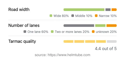
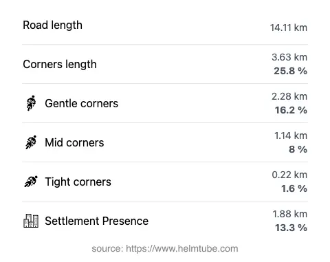
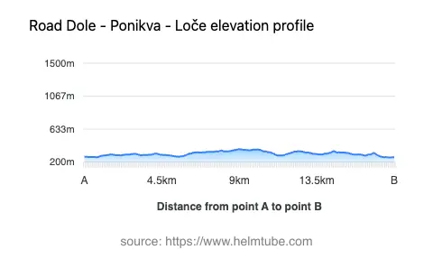
The Dole–Ponikva–Loče route extends for approximately 14.1 km (8.8 miles), with elevations ranging from 262 m (860 ft) to 371 m (1,217 ft). The road surface is asphalt and is generally of high quality, offering a smooth ride for most of its length. Riders will encounter a mix of one-lane (about 63%) and two-lane (about 23%) sections, with the majority of the road being wide (about 80%), allowing for comfortable passage even when meeting oncoming traffic. The route is moderately curvy, providing a balance between technical riding and relaxed touring. The maximum speed limits are 50 km/h (31 mph) and 60 km/h (37 mph), reflecting the road’s passage through both rural and semi-urban areas. Only a small proportion (13.3%) of the road passes through inhabited zones, making it suitable for uninterrupted riding.
Mountain Ranges and Natural Attractions
This road is notable for crossing three significant mountain ranges: the Alps, the Karavanke, and the Karawanken und Bachergebirge. While the elevations are moderate compared to the high Alpine passes, the surrounding landscape is characterized by rolling hills, forested slopes, and occasional open vistas. Riders may wish to make brief stops in the nearby settlements of Primož pri Šentjurju and Dole, or explore the cultural and historical sites in Šentjur and Slovenske Konjice. The region is also known for its vineyards and traditional Slovenian rural architecture, which can be observed along the route.
Road Closures, Seasonal Considerations, and Regulations
There are currently no known restrictions or closures specific to motorcycles on the Dole–Ponikva–Loče road. The route is not subject to regular winter closures, as it does not reach high elevations where snow would typically cause prolonged blockages. However, riders should remain aware of occasional short-term closures due to local events or roadworks, which are usually announced by the Slovenian Traffic Information Center. It is advisable to check for updates before planning a ride, especially during periods of adverse weather.
Tolls, Fees, and Practical Information
The Dole–Ponikva–Loče road does not currently require a toll or entrance fee for motorcycles. Riders should note that toll conditions may change in the future, and it is recommended to consult the DARS (Motorway Company in the Republic of Slovenia) website for the most up-to-date information regarding tolls and vignettes in Slovenia. While this particular road is not part of the national motorway network, awareness of toll requirements is essential for riders planning longer journeys in the country.
Explore the Region: Roads Close By
Discover more amazing roads located near the route featured in this article. The list below highlights nearby routes that are perfect for extending your ride or planning your next adventure.
Ride the Best: Slovenia’s Top Motorcycle Roads
These are the best motorbiking roads in Slovenia. The list below shows links to articles about top-rated motorcycle routes in the country. Explore the most popular roads in Slovenia and plan your next unforgettable motorbike adventure.