Exploring Državna cesta D32: A Motorcyclist’s Guide Through Risnjak National Park
Locals know best!
If you travel this road often or live close by you will be given a chance to provide your valuable rating soon! Sign in and stay connected.Location and Route Overview
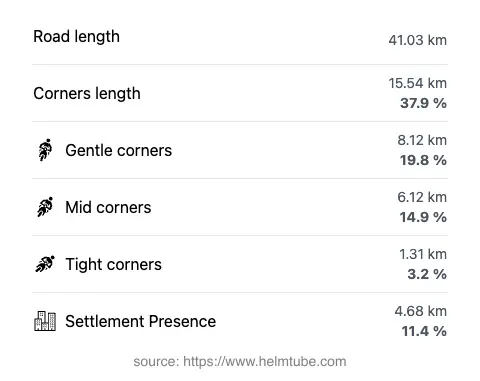
Državna cesta D32 is situated in the northwestern part of Croatia, within the Gorski Kotar region. The road begins near the town of Čabar and extends southeast towards Delnice, traversing a distance of approximately 41 km (25.5 miles). The route passes through settlements such as Čabarska ulica, 1. Maja, and Goranska, and is characterized by its passage through the dense forests and rolling hills of the region. Notably, a significant portion of D32 runs through Risnjak National Park, a protected area renowned for its biodiversity and mountainous landscapes. An interactive map showing the road’s course is available at the end of this article.
Road Characteristics and Riding Experience
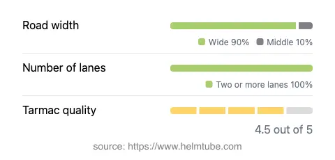
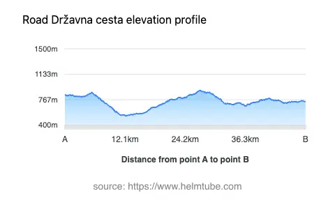
The D32 offers a moderately curvy ride, with bends that are engaging but not overly technical, making it suitable for a wide range of motorcyclists. The road surface is asphalt and is generally rated as very good, providing a smooth and predictable riding experience. The majority of the route features two wide lanes (about 90%), allowing for comfortable overtaking and maneuvering. Only a small proportion of the road is of medium width, and there are virtually no narrow sections. The elevation ranges from 534 m (1,752 ft) at its lowest point to 900 m (2,953 ft) at its highest, offering riders a gradual ascent through the mountainous terrain. The maximum speed limit is 50 km/h (31 mph), reflecting the road’s passage through protected and occasionally inhabited areas. Approximately 11% of the route passes through settlements, while the remainder traverses forested and natural landscapes.
Risnjak National Park: A Unique Riding Environment
One of the defining features of Državna cesta D32 is its intersection with Risnjak National Park. The park is a significant natural attraction in Croatia, known for its diverse flora and fauna, as well as its mountainous terrain. Motorcyclists riding through this section can expect to encounter dense forests, occasional wildlife sightings, and panoramic views of the surrounding peaks. The park’s protected status means that riders should be mindful of local regulations, including speed limits and restrictions on stopping in certain areas. For more information about the park and its regulations, visit the official Risnjak National Park website or consult the Wikipedia entry for Risnjak National Park.
Road Closures, Seasonal Access, and Fees
Državna cesta D32 is generally open to motorcycles throughout the year. However, due to its elevation and location within a mountainous region, temporary closures can occur during winter months as a result of snow or adverse weather conditions. Riders are advised to check local traffic updates and the Risnjak National Park website for the latest information on road accessibility, especially during the colder seasons. There are currently no tolls or entrance fees specifically for using D32 itself, but entry into certain areas of Risnjak National Park may require a ticket. Toll and fee conditions may change in the future; for up-to-date information on road tolls and entrance fees in Croatia, refer to the Hrvatske autoceste toll rates page.
Nearby Towns and Points of Interest
The D32 connects two notable towns: Čabar at the northwestern end and Delnice at the southeastern terminus. Both towns serve as convenient starting or ending points for a ride along this route. Čabar is a small town known for its proximity to the Slovenian border and its traditional architecture, while Delnice is the largest town in Gorski Kotar and offers a range of services for travelers. In addition to Risnjak National Park, riders may wish to explore local attractions such as the Kupa River valley or the historic sites in Delnice. These destinations provide opportunities for rest, sightseeing, and further exploration of the region’s natural and cultural heritage.
Explore the Region: Roads Close By
Discover more amazing roads located near the route featured in this article. The list below highlights nearby routes that are perfect for extending your ride or planning your next adventure.
Ride the Best: Croatia’s Top Motorcycle Roads
These are the best motorbiking roads in Croatia. The list below shows links to articles about top-rated motorcycle routes in the country. Explore the most popular roads in Croatia and plan your next unforgettable motorbike adventure.