Exploring the Dugopolje–Trilj Route: A Technical Overview for Motorcyclists
Locals know best!
If you travel this road often or live close by you will be given a chance to provide your valuable rating soon! Sign in and stay connected.Location and Regional Context
Lokalna cesta 67078 is situated in southern Croatia, running between the village of Dugopolje and the town of Trilj. The route lies within the Split-Dalmatia County, an area known for its karst landscapes and proximity to the Dinaric Alps. Dugopolje is located northeast of Split, serving as a gateway to the Dalmatian hinterland, while Trilj is positioned further inland, near the Cetina River. The road primarily serves local traffic but is also used by travelers seeking alternative inland routes away from the coastal congestion. An interactive map showing the precise alignment of Lokalna cesta 67078 can be found at the end of this article.
Road Characteristics and Technical Details
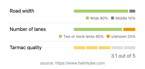
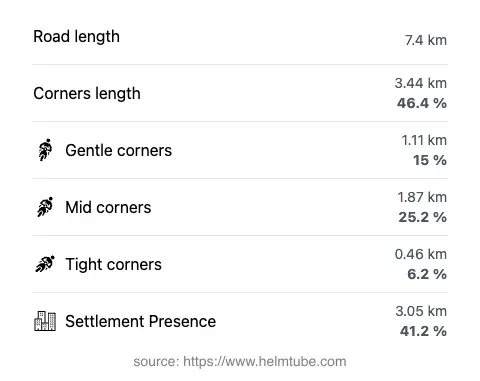
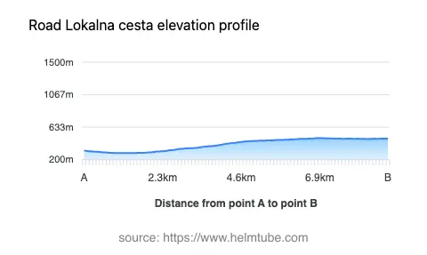
The total length of Lokalna cesta 67078 is approximately 7.4 km (4.6 miles), making it a short but useful connector for riders. The road features two lanes for the majority of its length (about 76%), with a wide carriageway for most of the route (about 94%). The surface is asphalt, rated as average in quality, which means riders should expect some uneven patches but generally manageable conditions. The route is moderately curvy, offering a mix of gentle and sharper bends, but does not present the extreme twistiness found in mountain passes. Elevation ranges from 288 m (945 ft) near Dugopolje to 487 m (1,598 ft) approaching Trilj, providing some mild elevation changes without significant gradients. Approximately 41% of the road passes through inhabited areas, particularly near the settlements at each end.
Local Attractions and Points of Interest
While Lokalna cesta 67078 itself is primarily a functional route, its endpoints offer access to several attractions. Dugopolje is known for its proximity to the Vranjača Cave, a notable karst cave system open to visitors. Trilj, on the other hand, is situated near the Cetina River, popular for rafting and outdoor activities. The area around Trilj also features remnants of Roman history, such as the Tilurium archaeological site. These attractions make the route a practical choice for riders interested in combining a ride with local sightseeing.
Road Closures and Seasonal Considerations
Lokalna cesta 67078 is a local road and is generally open to motorcycles year-round. There are no regular seasonal closures, and the route is not subject to winter shutdowns typical of higher mountain passes. However, temporary closures may occur due to roadworks or local events, particularly in the settlements. Riders are advised to check with the Croatian Automobile Club (HAK) for up-to-date information on road conditions and any event-related disruptions before planning their journey.
Tolls, Fees, and Practical Information
There are currently no tolls or entrance fees required to use Lokalna cesta 67078. The road is a public local route, accessible to all vehicles, including motorcycles. Riders should note that toll conditions may change in the future, and it is advisable to consult the Croatian Automobile Club (HAK) website for the latest information on road tolls and entrance fees in Croatia. Fuel stations and basic services are available in both Dugopolje and Trilj, but options are limited along the route itself.
Explore the Region: Roads Close By
Discover more amazing roads located near the route featured in this article. The list below highlights nearby routes that are perfect for extending your ride or planning your next adventure.
Ride the Best: Croatia’s Top Motorcycle Roads
These are the best motorbiking roads in Croatia. The list below shows links to articles about top-rated motorcycle routes in the country. Explore the most popular roads in Croatia and plan your next unforgettable motorbike adventure.