Exploring the Ebenhochstraße: A Technical Ride Along the Ranna River
Locals know best!
If you travel this road often or live close by you will be given a chance to provide your valuable rating soon! Sign in and stay connected.Location and Route Overview
The Ebenhochstraße is situated in Upper Austria, running between the settlements of Ebenhochstraße and Falkenweg, with the village of Niederranna marking its endpoint. The road traverses a region characterized by rolling hills and river valleys, following the course of the Ranna River for a significant portion of its length. This area is known for its tranquil rural landscapes and proximity to the Danube, making it a notable route for those interested in exploring the Austrian countryside by motorcycle. An interactive map showing the precise route of the Ebenhochstraße can be found at the end of this article.
Road Characteristics and Riding Experience
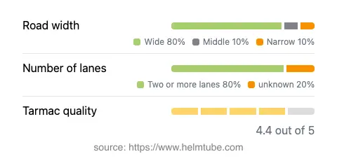
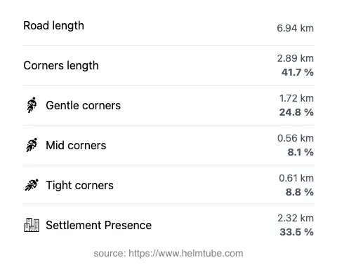
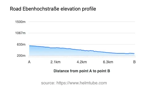
The Ebenhochstraße extends for approximately 6.9 km (4.3 miles), offering a moderately curvy ride that will appeal to riders seeking a balance between technical engagement and relaxed touring. The road surface is asphalt and is generally rated as very good, providing a smooth and predictable riding experience. Most of the route consists of two lanes (about 83%), with the majority of the road being wide (about 75%), which allows for comfortable passing and maneuvering. Only a small portion is narrow or single-lane, so traffic flow is rarely impeded. The elevation ranges from 281 m (922 ft) at its lowest point to 581 m (1,906 ft) at its highest, offering some gentle climbs and descents. The maximum speed limits along the route are 50 km/h (31 mph) and 80 km/h (50 mph), depending on the section. Approximately one-third of the road passes through inhabited areas, so riders should remain attentive to local traffic and pedestrians.
Natural Features and Attractions
One of the defining features of the Ebenhochstraße is its proximity to the Ranna River, which it follows for about a quarter of its length. The river eventually flows into the Danube, adding to the region’s hydrological significance. Along the route, riders will encounter at least one designated viewpoint, offering opportunities to pause and appreciate the surrounding landscape. The area is also close to the village of Niederranna, which serves as a convenient stop for refreshments or exploration. While the road itself is not widely known for major tourist attractions, its setting provides access to the broader attractions of the Upper Austrian countryside and the Danube valley.
Road Closures, Seasonal Access, and Regulations
There are currently no known restrictions or closures specific to motorcycles on the Ebenhochstraße. The road remains open throughout the year, although riders should be aware that winter conditions in Upper Austria can affect surface quality and traction. Temporary closures may occur due to maintenance or local events, so it is advisable to check with local authorities or the ASFINAG traffic reports before planning a ride, especially during the winter months or periods of inclement weather.
Tolls, Fees, and Practical Information
The Ebenhochstraße does not currently require a toll or entrance fee for motorcycles. However, toll conditions in Austria may change, and it is recommended to consult official resources for the most up-to-date information. For comprehensive details on road tolls and vignette requirements in Austria, riders can refer to the ASFINAG vignette information page. Always ensure compliance with local regulations to avoid fines or penalties.
Explore the Region: Roads Close By
Discover more amazing roads located near the route featured in this article. The list below highlights nearby routes that are perfect for extending your ride or planning your next adventure.
Ride the Best: Austria’s Top Motorcycle Roads
These are the best motorbiking roads in Austria. The list below shows links to articles about top-rated motorcycle routes in the country. Explore the most popular roads in Austria and plan your next unforgettable motorbike adventure.