Exploring Croatia’s D23: A Motorcyclist’s Guide to the Frankopanska Route
Locals know best!
If you travel this road often or live close by you will be given a chance to provide your valuable rating soon! Sign in and stay connected.Location and Overview of the D23
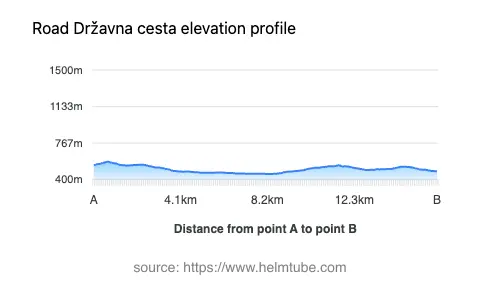
The D23 is a state road situated in Croatia, running through the Lika-Senj County. It begins near the village of Križpolje and passes through the settlement of Frankopanska, serving as a connector between inland Croatia and the Adriatic coast. The route is positioned in a region characterized by rolling hills and forested landscapes, with elevations ranging from 456 m (1,496 ft) to 580 m (1,903 ft). The road’s location makes it a practical choice for riders seeking a less congested alternative to the main coastal highways. An interactive map showing the D23 route can be found at the end of this article.
Road Characteristics and Riding Experience
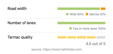
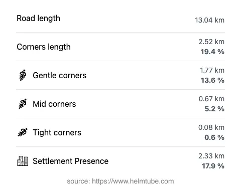
The D23 extends for approximately 13 km (8.1 miles), offering a predominantly wide carriageway (about 90%) that supports two-way traffic along nearly its entire length. The road is surfaced with asphalt of high quality, rated as excellent by local standards. Riders will find the route gently curved, making it suitable for both novice and experienced motorcyclists. The road’s alignment is not particularly twisty, allowing for a relaxed ride while still providing enough variation to maintain interest. With a maximum speed limit varying between 40 km/h (25 mph), 50 km/h (31 mph), 60 km/h (37 mph), and 90 km/h (56 mph) depending on the section, the D23 accommodates a range of riding styles. The route passes through inhabited areas for roughly 18% of its length, with the remainder traversing open countryside and forested stretches.
Points of Interest Along the D23
While the D23 is primarily a transit route, it does offer access to local attractions. Notably, there is a viewpoint along the road that provides expansive views of the surrounding Lika landscape. This spot is ideal for a brief stop to appreciate the region’s natural beauty. The proximity to Križpolje, a traditional Croatian village, allows riders to experience local culture and hospitality. For those interested in exploring further, the broader region is known for its proximity to the Plitvice Lakes National Park, a UNESCO World Heritage site, although the park itself is not directly on the D23. The road’s rural setting ensures a peaceful ride, with minimal heavy traffic and opportunities to observe local wildlife.
Seasonal Closures and Road Access
The D23 remains open to motorcycles throughout the year, with no specific seasonal closures reported. However, riders should be aware that winter conditions in the Lika region can be severe, with occasional snow and ice affecting road safety. During such periods, local authorities may impose temporary restrictions or advisories, particularly for vehicles without appropriate winter equipment. There are no known event-related closures affecting the D23, but it is advisable to check local traffic updates before planning a ride, especially in winter months.
Tolls, Fees, and Practical Information
Currently, there are no tolls or entrance fees required to use the D23. The road is part of Croatia’s public state road network and is accessible to all motor vehicles, including motorcycles. Riders should note that toll conditions may change in the future, and it is recommended to consult the Hrvatske autoceste website for the most up-to-date information on road tolls and entrance fees in Croatia. Fuel stations and basic amenities are available in nearby settlements, but services directly on the D23 are limited, so planning ahead is advisable.
Explore the Region: Roads Close By
Discover more amazing roads located near the route featured in this article. The list below highlights nearby routes that are perfect for extending your ride or planning your next adventure.
Ride the Best: Croatia’s Top Motorcycle Roads
These are the best motorbiking roads in Croatia. The list below shows links to articles about top-rated motorcycle routes in the country. Explore the most popular roads in Croatia and plan your next unforgettable motorbike adventure.