Exploring the Freistadt–Unterweißenbach Route: A Motorcyclist’s Guide
Locals know best!
If you travel this road often or live close by you will be given a chance to provide your valuable rating soon! Sign in and stay connected.Location and Overview of the Freistadt–Unterweißenbach Road
The Freistadt–Unterweißenbach road is situated in the northern part of Upper Austria, within the Mühlviertel region. The route begins near the town of Freistadt, a settlement known for its medieval fortifications and historical significance. From there, the road travels northeast, passing through a series of small settlements including Nordkammstraße, Freistädterstraße, Am Anger, Markt, Lederersberg, and Freistädter Straße, before reaching the village of Unterweißenbach. The route traverses a landscape characterized by rolling hills, forests, and agricultural land, offering a representative cross-section of the region’s rural environment. An interactive map showing the precise route can be found at the end of this article.
Road Characteristics and Riding Experience
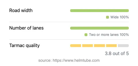
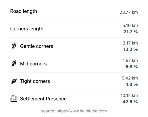
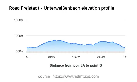
The Freistadt–Unterweißenbach road extends for approximately 23.8 km (14.8 miles), making it a manageable journey for a half-day ride or as part of a longer tour through Upper Austria. The road is predominantly wide (about 95%), with a small proportion being of medium width. Two lanes are present along most of the route (about 97%), ensuring comfortable passage for both motorcycles and other vehicles. The surface is asphalt, with a quality rating that can be described as good, though not exceptional. Riders can expect a moderately curvy experience, with the road offering a mix of gentle bends and straight sections, suitable for both novice and experienced motorcyclists. The elevation ranges from 609 m (1,998 ft) to 856 m (2,808 ft), providing some mild altitude changes without significant mountain pass characteristics. The maximum speed limit is 50 km/h (31 mph), reflecting the road’s passage through inhabited areas and its regional road status.
Points of Interest and Attractions Along the Route
While the Freistadt–Unterweißenbach road is primarily a connector between rural settlements, it does offer access to several points of interest. The starting point, Freistadt, is notable for its preserved medieval old town, city walls, and the Freistadt Castle. Along the route, riders will encounter a viewpoint, providing an opportunity to pause and appreciate the surrounding Mühlviertel landscape. The endpoint, Unterweißenbach, is a typical Upper Austrian village, offering a glimpse into local rural life. The road itself does not pass directly by major tourist attractions, but its proximity to the Mühlviertel region’s forests and rolling hills makes it a suitable base for further exploration.
Road Closures, Seasonal Considerations, and Regulations
The Freistadt–Unterweißenbach road is a public regional road and is generally open to motorcycles throughout the year. There are no known permanent closures for motorcycles, and the route is not subject to regular winter closures. However, as with many roads in Upper Austria, temporary closures may occur due to roadworks, local events, or adverse weather conditions, particularly in winter months when snow and ice can affect driving conditions. Riders are advised to check local traffic updates before planning their journey. No event-related closures have been reported for this route.
Tolls, Fees, and Additional Information
There are currently no tolls or entrance fees required to use the Freistadt–Unterweißenbach road. The route is part of the regional road network and is accessible to all vehicles, including motorcycles, without charge. Riders should note that toll conditions may change in the future, and it is advisable to consult official resources for the most up-to-date information. For comprehensive details on tolls and road fees in Austria, visit the ASFINAG website.
Explore the Region: Roads Close By
Discover more amazing roads located near the route featured in this article. The list below highlights nearby routes that are perfect for extending your ride or planning your next adventure.
Ride the Best: Austria’s Top Motorcycle Roads
These are the best motorbiking roads in Austria. The list below shows links to articles about top-rated motorcycle routes in the country. Explore the most popular roads in Austria and plan your next unforgettable motorbike adventure.