Furkajoch (Furkajoch) - L51: A Technical Overview for Motorcyclists
Locals know best!
If you travel this road often or live close by you will be given a chance to provide your valuable rating soon! Sign in and stay connected.Location and Geographic Context
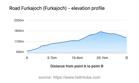
The Furkajoch (Furkajoch) - L51 is situated in western Austria, within the federal state of Vorarlberg. The road connects the town of Rankweil at its western end to the village of Damüls in the east, passing through the Laternsertal valley and crossing the Furkajoch mountain pass at an elevation of 1,759 m (5,771 ft). The route is embedded in the Bregenzerwaldgebirge, a subrange of the Alps, and intersects the Hohe Kugel - Hoher Freschen - Mellental nature reserve. The road also runs adjacent to the Frutz and Argenbach rivers for significant portions of its length. An interactive map showing the route can be found at the end of this article.
Road Characteristics and Riding Experience
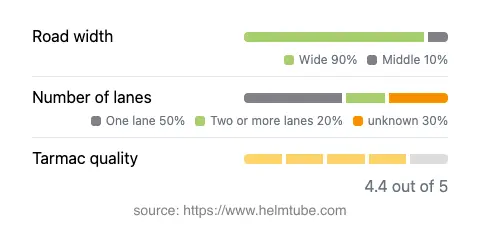
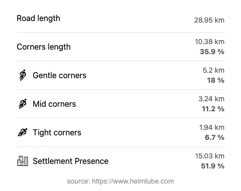
The L51 extends for approximately 28.95 km (18 miles), offering a mix of gently curved and moderately twisty sections. The road surface is asphalt and is generally rated as very good, providing reliable grip and comfort for motorcyclists. The majority of the route is wide (about 85%), with some middle-width segments (12%) and a minimal proportion of narrow stretches (1%). Lane configuration varies, with just over half of the road being single-lane (about 51%) and a smaller portion featuring two lanes (about 18%). The elevation ranges from 475 m (1,558 ft) at its lowest point to 1,750 m (5,741 ft) at its highest, with the Furkajoch pass itself reaching 1,759 m (5,771 ft). The road passes through inhabited areas for just over half its length, providing a blend of rural and alpine environments. Speed limits along the L51 fluctuate between 40 km/h (25 mph) and 80 km/h (50 mph), depending on the section and proximity to settlements.
Seasonal Accessibility and Closures
The Furkajoch (Furkajoch) - L51 is subject to seasonal closures due to snow and adverse weather conditions. Typically, the pass is closed to all traffic, including motorcycles, during the winter months, often from late autumn until late spring. The exact dates of closure can vary annually depending on weather patterns and snow accumulation. There are no regular event-related closures reported, but temporary restrictions may occur due to maintenance or local events. For up-to-date information on road status, it is advisable to consult the ASFINAG Traffic Reports website.
Tolls, Fees, and Regulations
Currently, there is no toll or entrance fee required for motorcycles or other vehicles to use the Furkajoch (Furkajoch) - L51. However, toll conditions may change in the future, and it is recommended to verify the latest information before planning a trip. For comprehensive details on road tolls and regulations in Austria, refer to the ASFINAG Toll Information page.
Natural Features and Points of Interest
The L51 traverses the Hohe Kugel - Hoher Freschen - Mellental nature reserve, an area recognized for its alpine flora and fauna. Riders will pass through the Laternsertal valley, which offers views of traditional alpine settlements and landscapes. The route also runs alongside the Frutz and Argenbach rivers, both of which are tributaries to larger river systems in the region. The Bregenzerwaldgebirge, or Bregenz Forest Mountains, provide a dramatic backdrop throughout the journey. For more information on the region's geography and attractions, visit the Bregenz Forest Mountains and Hohe Kugel - Hoher Freschen - Mellental Nature Reserve Wikipedia pages.
Explore the Region: Roads Close By
Discover more amazing roads located near the route featured in this article. The list below highlights nearby routes that are perfect for extending your ride or planning your next adventure.
Ride the Best: Austria’s Top Motorcycle Roads
These are the best motorbiking roads in Austria. The list below shows links to articles about top-rated motorcycle routes in the country. Explore the most popular roads in Austria and plan your next unforgettable motorbike adventure.