Exploring the B4 Road: A Motorcyclist’s Guide through Lower Austria
Locals know best!
If you travel this road often or live close by you will be given a chance to provide your valuable rating soon! Sign in and stay connected.Location and Overview of the B4 Road
The B4, or Horner Straße, is situated in the northeastern part of Austria, traversing the Lower Austria region. The road stretches between the vicinity of Zwettl and extends towards the east, passing through a mix of inhabited areas and open countryside. The starting point is located approximately 7 km (4.3 miles) from the town of Zwettl, a settlement known for its historic abbey and picturesque setting. The B4 serves as a connector between several rural communities and is recognized for its accessibility and infrastructure. An interactive map showing the route of the B4 can be found at the end of this article.
Road Characteristics and Riding Experience
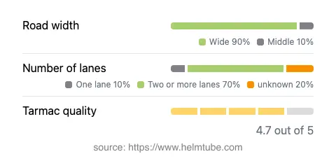
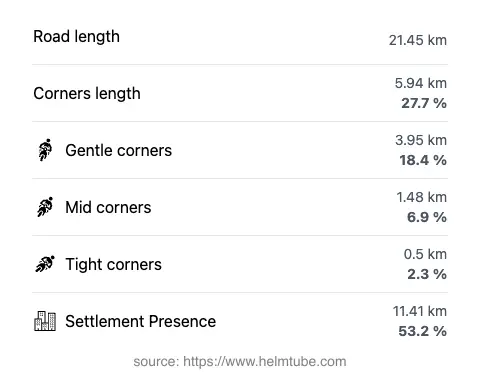
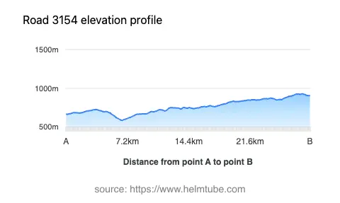
The B4 road covers a distance of approximately 21.5 km (13.4 miles), with elevations ranging from 586 m (1,923 ft) to 929 m (3,048 ft). The road surface is asphalt and is generally rated as excellent, providing a smooth and predictable ride. The majority of the route features wide lanes (about 87%), with two lanes being predominant (about 72%), ensuring ample space for overtaking and maneuvering. The road is gently curved, making it suitable for riders who prefer a relaxed journey over highly technical riding. About 53% of the B4 passes through inhabited areas, offering glimpses of local life and easy access to amenities. The maximum speed limits along the route vary between 50, 60, and 70 km/h (31, 37, and 43 mph), depending on the specific section and proximity to settlements.
Tourist Attractions and Points of Interest
One of the notable features of the B4 is its proximity to several viewpoints, providing opportunities for riders to pause and appreciate the surrounding landscapes. The region is characterized by rolling hills, forests, and agricultural land, typical of Lower Austria. Zwettl, near the starting point, is home to the Zwettl Abbey, a Cistercian monastery with a rich history dating back to the 12th century. The area also offers access to local hiking trails and rural attractions, making it a suitable base for further exploration. While the B4 itself is not renowned for dramatic mountain scenery, its viewpoints and rural charm contribute to a pleasant touring experience.
Road Closures, Seasonal Access, and Regulations
The B4 (Horner Straße) is a public road and remains open to motorcycles throughout the year. There are no regular seasonal closures, although temporary restrictions may occur due to roadworks or local events. Riders are advised to check for any updates on closures or traffic conditions before planning their journey. Information on current road conditions and closures can be found on the official ASFINAG Traffic Information website.
Tolls, Fees, and Additional Information
There are no tolls or entrance fees required for motorcycles on the B4 road. The route is part of Austria’s federal road network and is free to use for all vehicles, including motorcycles. However, toll conditions may change in the future, and riders should consult the official ASFINAG Toll Information page for the most up-to-date details regarding tolls and vignettes for Austrian roads.
Explore the Region: Roads Close By
Discover more amazing roads located near the route featured in this article. The list below highlights nearby routes that are perfect for extending your ride or planning your next adventure.
Ride the Best: Austria’s Top Motorcycle Roads
These are the best motorbiking roads in Austria. The list below shows links to articles about top-rated motorcycle routes in the country. Explore the most popular roads in Austria and plan your next unforgettable motorbike adventure.