Riding the Hvar Island Viewpoint Road: A Motorcyclist’s Guide to Županijska cesta 6252
Locals know best!
If you travel this road often or live close by you will be given a chance to provide your valuable rating soon! Sign in and stay connected.Location and Route Overview
Županijska cesta 6252 is situated entirely on Hvar Island, Croatia’s sunniest and one of its most popular Adriatic islands. The road runs between the historic town of Hvar on the island’s southwestern coast and Stari Grad to the north. The route passes through the settlement of Jerka Mišetića and is characterized by its Mediterranean setting, with olive groves, vineyards, and pine forests lining much of the way. An interactive map showing the road’s course can be found at the end of this article.
Road Characteristics and Riding Experience
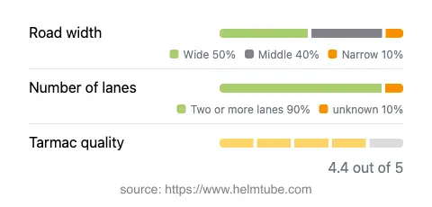
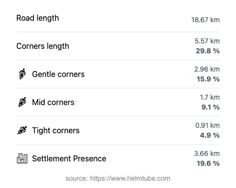
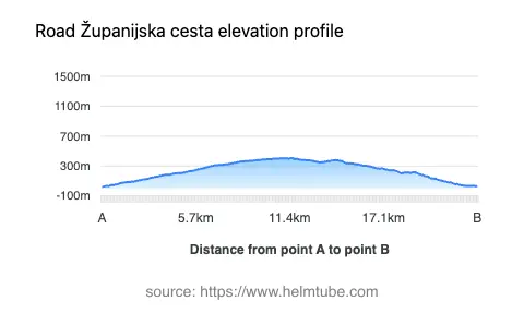
The road stretches for approximately 18.7 km (11.6 miles), with elevations ranging from 17 m (56 ft) near the coast to a maximum of 408 m (1,339 ft) as it crosses the island’s central ridge. The surface is asphalt and generally rated as very good, offering a smooth ride for most motorcycles. Riders will encounter a moderately curvy alignment, with bends that are engaging but not overly technical, making it suitable for a range of skill levels. The majority of the road is wide (about 50%), with the remainder being of medium width (about 37%) and only a small portion considered narrow. Two lanes are present along most of the route (about 88%), ensuring comfortable passing opportunities. The road passes through inhabited areas for roughly 20% of its length, with the remainder traversing rural and natural landscapes.
Viewpoints and Attractions Along the Route
One of the highlights of Županijska cesta 6252 is its proximity to several viewpoints offering expansive vistas of the Adriatic Sea and the surrounding islands. While the road itself is not officially designated as a scenic route, riders will find multiple opportunities to stop and enjoy the landscape, particularly near the central ridge where the elevation peaks. The route also provides access to the UNESCO-listed Stari Grad Plain, an ancient agricultural landscape that is uniquely tied to Hvar. Both Hvar and Stari Grad towns are rich in history and culture, with attractions such as the Hvar Fortress and the Cathedral of St. Stephen providing additional points of interest for visitors.
Practical Information: Closures, Tolls, and Regulations
Županijska cesta 6252 is open to motorcycles year-round, with no regular seasonal closures reported. However, weather conditions during winter months can occasionally affect riding comfort, particularly in elevated sections where wind and rain may be more pronounced. There are no tolls or entrance fees required to use this road, but toll conditions may change in the future. For up-to-date information on road tolls and regulations in Croatia, riders should consult the Croatian Automobile Club (HAK) website. Standard speed limits apply, with maximum speeds of 50 km/h (31 mph) in inhabited areas and 30 km/h (19 mph) in certain sections, as posted. Riders are advised to observe local signage and adjust their speed according to road and weather conditions.
Access, Services, and Rider Tips
The road is easily accessed from both Hvar and Stari Grad, with ferry connections available to the mainland at Stari Grad. Fuel stations, accommodation, and dining options are available in both towns, but services are limited along the route itself. Riders should ensure their motorcycles are adequately fueled before departure. The route’s moderate curves and generally wide lanes make it suitable for both solo riders and groups. Due to the popularity of Hvar Island during the summer months, increased traffic can be expected, particularly near the towns and major attractions. Early morning or late afternoon rides are recommended for those seeking a quieter experience. Always wear appropriate protective gear and remain vigilant for local wildlife or agricultural vehicles, especially in rural sections.
Explore the Region: Roads Close By
Discover more amazing roads located near the route featured in this article. The list below highlights nearby routes that are perfect for extending your ride or planning your next adventure.
Ride the Best: Croatia’s Top Motorcycle Roads
These are the best motorbiking roads in Croatia. The list below shows links to articles about top-rated motorcycle routes in the country. Explore the most popular roads in Croatia and plan your next unforgettable motorbike adventure.