Exploring the Pitve–Zavala Tunnel Road on Hvar Island: A Motorcyclist’s Guide
Locals know best!
If you travel this road often or live close by you will be given a chance to provide your valuable rating soon! Sign in and stay connected.Location and Overview of the Pitve–Zavala Tunnel Road
The Pitve–Zavala Tunnel Road is situated entirely on Hvar Island, Croatia’s sunniest and one of its most popular Adriatic islands. The road connects the northern settlement of Pitve with Zavala on the southern coast, passing through the island’s mountainous interior. The route is notable for the Pitve–Zavala Tunnel, a single-lane passage carved through the rock, which serves as a vital link between the two sides of the island. The nearest major town to both the starting and ending points is Stari Grad, located approximately 4.8 km (3 miles) from the tunnel’s northern entrance. An interactive map showing the road’s route can be found at the end of this article.
Road Characteristics and Riding Experience
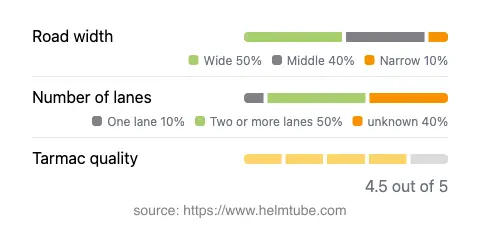
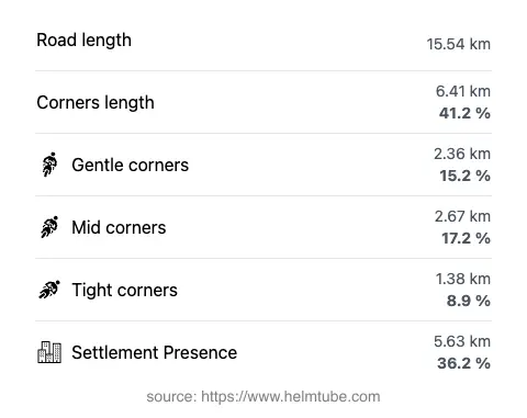
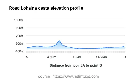
The Pitve–Zavala Tunnel Road, officially designated as Lokalna cesta 67190, extends for approximately 15.5 km (9.6 miles) across Hvar Island. The road surface is asphalt and is generally of high quality, with most sections rated as very good. Riders will encounter a mix of road widths: about half of the route is considered wide (about 48%), while the remainder alternates between middle and narrow sections. The road features a gently curving profile, with some sections offering more pronounced bends, particularly near the tunnel and on the southern descent toward Zavala. The elevation ranges from 43 m (141 ft) at its lowest point to 446 m (1,463 ft) at its highest, providing a varied riding experience. The route passes through both inhabited and uninhabited areas, with roughly a third of its length traversing settlements or their outskirts.
The Pitve–Zavala Tunnel: A Unique Passage
The defining feature of this road is the Pitve–Zavala Tunnel, a narrow, unlit, and single-lane tunnel that cuts through the island’s central ridge. Originally constructed in the 1960s, the tunnel is approximately 1.4 km (0.87 miles) long and is known for its raw, unfinished rock walls and minimal infrastructure. Motorcyclists should exercise caution when entering, as the tunnel is only wide enough for one vehicle at a time and visibility is limited. Passing through the tunnel is an experience in itself, offering a sense of adventure and a direct connection to the island’s rugged geology. The tunnel is open year-round, but riders should be aware that closures may occur due to maintenance or local events. There are no permanent restrictions for motorcycles, but it is advisable to check local sources for any temporary closures before planning a ride.
Viewpoints and Attractions Along the Route
The road offers access to several viewpoints that provide expansive vistas of Hvar’s interior and the Adriatic Sea. Notable stops include the lookout points near Pitve and Zavala, where riders can pause to take in panoramic views of the island’s terraced hillsides and coastline. The southern end of the road leads to Zavala, a small coastal village known for its tranquil beaches and proximity to the Zavala Beach. The northern approach passes close to Pitve, a traditional Dalmatian village with stone houses and a rich history. These attractions are uniquely tied to the area and offer opportunities for rest and exploration during a motorcycle journey.
Practical Information: Speed Limits, Tolls, and Seasonal Considerations
The maximum speed limit on the Pitve–Zavala Tunnel Road varies between 30 km/h (19 mph) in the tunnel and more populated areas, and up to 90 km/h (56 mph) on open stretches. The road is generally open throughout the year, but weather conditions, particularly during winter, can affect accessibility due to occasional heavy rains or maintenance work. There are currently no tolls or entrance fees for motorcycles or other vehicles using this road. However, toll conditions may change in the future. For up-to-date information on road tolls and entrance fees in Croatia, consult the Croatian Automobile Club (HAK) website. Riders are advised to carry basic safety equipment and to be prepared for sudden changes in road width and lighting, especially when approaching the tunnel.
Explore the Region: Roads Close By
Discover more amazing roads located near the route featured in this article. The list below highlights nearby routes that are perfect for extending your ride or planning your next adventure.
Ride the Best: Croatia’s Top Motorcycle Roads
These are the best motorbiking roads in Croatia. The list below shows links to articles about top-rated motorcycle routes in the country. Explore the most popular roads in Croatia and plan your next unforgettable motorbike adventure.