Exploring the Kamniška Bistrica Valley: Stahovica to Kamniška Bistrica by Motorcycle
Locals know best!
If you travel this road often or live close by you will be given a chance to provide your valuable rating soon! Sign in and stay connected.Location and Access
The Stahovica – Kamniška Bistrica road is situated in northern Slovenia, beginning near the settlement of Stahovica and terminating at Kamniška Bistrica. The nearest major town is Kamnik, located approximately 4.5 km (2.8 miles) from the starting point. The route follows the Kamniška Bistrica River for most of its length, guiding riders through a valley framed by the Kamniško-Savinjske Alps. This area is recognized for its accessibility to hiking trails, mountain lodges, and natural springs. An interactive map showing the road can be found at the end of the article.
Road Characteristics and Riding Experience
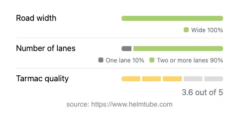
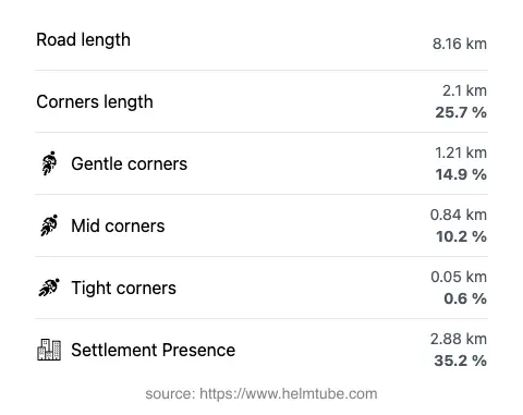
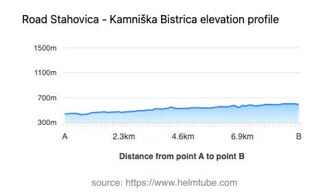
The road covers a distance of 8.16 km (5.1 miles), with an elevation range from 430 m (1,411 ft) to 604 m (1,982 ft). The surface is asphalt of moderate quality, providing a generally comfortable ride, though some sections may exhibit minor wear. The route is predominantly wide (about 90%), with two lanes for most of its length, allowing for straightforward passing and maneuvering. The road is gently curved, making it suitable for riders of all skill levels. Speed limits are set at 50 km/h (31 mph), reflecting the road’s mixed use and proximity to inhabited areas. Approximately 35% of the route passes through settlements, while the remainder traverses forested and alpine terrain. The road closely parallels the Kamniška Bistrica River for over 90% of its length, offering frequent views of the water and the surrounding valley.
Natural Features and Points of Interest
This route is notable for its passage through the Kamniška Bistrica Valley, a region known for its pristine river, glacial springs, and access to the Kamniško-Savinjske Alpe. The valley is a popular starting point for hiking and mountaineering, with several trailheads and mountain huts accessible from the road’s terminus. The area also features the Kamniška Bistrica spring, a natural attraction drawing visitors for its clear waters and tranquil setting. The road’s proximity to the river and the surrounding valleys—such as Korošica, Veliki Predoselj, and Mali Predoselj—provides a varied landscape, with opportunities to observe alpine flora and fauna. The route does not traverse high mountain passes, but it does offer a direct approach to the alpine environment, making it a practical choice for riders interested in exploring the region’s natural assets.
Seasonal Access, Closures, and Regulations
The Stahovica – Kamniška Bistrica road remains open to motorcycles throughout the year, barring temporary closures due to maintenance or adverse weather conditions. Winter access is generally maintained, though heavy snowfall or ice may occasionally result in short-term restrictions. There are no regular event-related closures affecting this route. Riders are advised to check local traffic updates before departure, especially during periods of inclement weather or public holidays when increased visitor numbers may impact travel.
Tolls, Fees, and Further Information
There are currently no tolls or entrance fees required to use the Stahovica – Kamniška Bistrica road. However, toll conditions may change in the future, and riders should verify the latest information before planning their trip. For up-to-date details on road tolls and entrance fees in Slovenia, consult the official DARS website. Parking at certain trailheads or attractions along the route may incur a separate fee, which is typically posted on-site.
Explore the Region: Roads Close By
Discover more amazing roads located near the route featured in this article. The list below highlights nearby routes that are perfect for extending your ride or planning your next adventure.
Ride the Best: Slovenia’s Top Motorcycle Roads
These are the best motorbiking roads in Slovenia. The list below shows links to articles about top-rated motorcycle routes in the country. Explore the most popular roads in Slovenia and plan your next unforgettable motorbike adventure.