Exploring the Litija–Zagorje ob Savi Road: A Motorcyclist’s Guide
Locals know best!
If you travel this road often or live close by you will be given a chance to provide your valuable rating soon! Sign in and stay connected.Location and Overview
The Litija–Zagorje ob Savi road is situated in central Slovenia, linking the towns of Litija and Zagorje ob Savi. The route passes through the settlements of Ples, Podgorica pri Pečah, and Vidrga, traversing a region characterized by rolling hills and a mix of rural and semi-urban environments. The road serves as a connector between the Sava River valley and the Zasavje region, making it a practical choice for riders seeking to explore the heart of Slovenia. An interactive map showing the road can be found at the end of the article.
Road Characteristics and Riding Experience
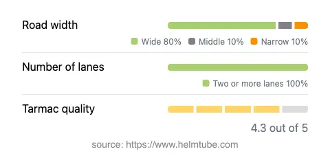
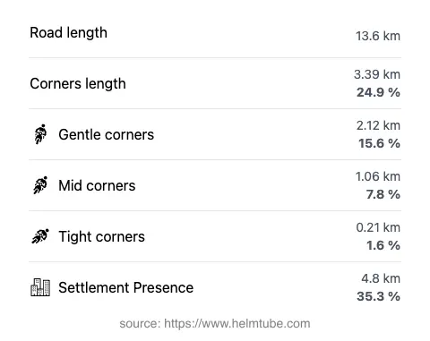
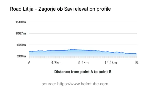
The Litija–Zagorje ob Savi road extends for approximately 13.6 km (8.5 miles), with an elevation range from 292 m (958 ft) to 471 m (1,545 ft). The road is surfaced with asphalt and is generally in very good condition, offering a smooth ride for most of its length. Riders will encounter a moderately curvy alignment, with bends that are neither too sharp nor completely straight, making it suitable for both experienced and less seasoned motorcyclists. The road is predominantly wide (about 83%), with some sections of medium width and a minimal proportion that is narrow. Two lanes are present for nearly the entire route (about 98%), ensuring comfortable passage for vehicles in both directions. Approximately 35% of the road passes through inhabited areas, providing occasional access to local amenities and services.
Local Attractions and Points of Interest
While the road itself is primarily a connector, the surrounding area offers several attractions worth noting. In Litija, visitors can explore the Litija Town Museum and the historic Sava River bridges. The town of Zagorje ob Savi is known for its mining heritage, with the Kisovec Coal Mine offering insights into the region’s industrial past. The settlements of Ples, Podgorica pri Pečah, and Vidrga provide a glimpse into rural Slovenian life, with opportunities for short stops and local refreshments. The route also offers access to hiking trails and viewpoints in the surrounding hills, making it a versatile option for riders interested in combining motorcycling with outdoor activities.
Road Closures and Seasonal Considerations
There are no permanent closures for motorcycles on the Litija–Zagorje ob Savi road. The route remains open throughout the year, although temporary closures may occur due to roadworks, local events, or adverse weather conditions, particularly during winter months when snow and ice can affect higher elevations. Riders are advised to check local traffic updates before departure, especially in the colder season, to ensure safe passage.
Tolls, Fees, and Practical Information
Currently, there are no tolls or entrance fees required for motorcycles on the Litija–Zagorje ob Savi road. However, toll conditions may change in the future, and it is recommended to consult the official DARS website for the latest information on road charges and regulations in Slovenia. Fuel stations and basic services are available in both Litija and Zagorje ob Savi, while smaller settlements along the route offer limited amenities. Riders should plan accordingly, especially if traveling outside regular business hours.
Interactive Map and Further Resources
For a detailed view of the Litija–Zagorje ob Savi road and its surroundings, an interactive map is available at the end of this article. Additional information about the region can be found on Wikivoyage and Lonely Planet. These resources provide further insights into travel options, attractions, and accommodations in central Slovenia.
Explore the Region: Roads Close By
Discover more amazing roads located near the route featured in this article. The list below highlights nearby routes that are perfect for extending your ride or planning your next adventure.
Ride the Best: Slovenia’s Top Motorcycle Roads
These are the best motorbiking roads in Slovenia. The list below shows links to articles about top-rated motorcycle routes in the country. Explore the most popular roads in Slovenia and plan your next unforgettable motorbike adventure.