Exploring the Trojane–Izlake–Trbovlje–Hrastnik–Šmarjeta Route: A Motorcyclist’s Guide Through the Slovenian Alps
Locals know best!
If you travel this road often or live close by you will be given a chance to provide your valuable rating soon! Sign in and stay connected.Location and Overview of the Route
The Trojane–Izlake–Trbovlje–Hrastnik–Šmarjeta route is situated in central Slovenia, running through the Zasavje region. The road begins near the settlement of Orehovica and passes through Izlake, Trbovlje, and Hrastnik before reaching Šmarjeta. This corridor serves as a connector between several towns, with the nearest major settlement being Zagorje ob Savi. The route crosses the foothills of the Alps, offering a blend of rural and urban landscapes. An interactive map showing the road can be found at the end of the article.
Technical Details and Riding Experience
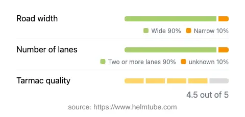
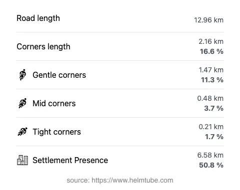
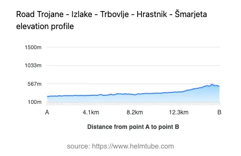
The road covers a distance of approximately 13 km (8.1 miles), with elevations ranging from 244 m (801 ft) to 558 m (1,831 ft). The surface is asphalt and is generally of high quality, rated as very good. The majority of the route features two lanes (about 90%), with the remainder being narrower sections. Most of the road is wide (about 90%), providing comfortable passage for motorcycles. The route is moderately curvy, with a layout that allows for a relaxed riding experience rather than aggressive cornering. Speed limits are typically set at 50–60 km/h (31–37 mph), reflecting the mix of inhabited and rural areas. Approximately half of the road passes through settlements, so riders should expect variable traffic conditions and occasional pedestrian crossings.
Local Attractions and Points of Interest
While the route itself is primarily a connector between towns, it passes near several points of interest. The town of Trbovlje is known for its industrial heritage and the Trbovlje Power Station, which features the tallest chimney in Europe. Trojane is famous for its traditional doughnuts, making it a popular stop for travelers. The surrounding Zasavje region is characterized by its mining history and offers opportunities for cultural exploration. Riders interested in local history may also visit the Litija Mining Museum, located a short ride from the main route.
Road Closures and Seasonal Considerations
The Trojane–Izlake–Trbovlje–Hrastnik–Šmarjeta road is a public road and is generally open to motorcycles year-round. There are no regular seasonal closures, although temporary restrictions may occur due to roadworks or local events. Winter conditions can affect riding safety, particularly in higher sections where snow and ice are possible. Riders are advised to check local traffic updates before departure, especially during adverse weather conditions. Information on current road conditions can be found on the Slovenian Traffic Information Center website.
Tolls, Fees, and Practical Information
There are currently no tolls or entrance fees for motorcycles on this route. The road is part of the regional network and does not require a vignette or special permit for motorcycles. However, toll conditions may change in the future, so it is advisable to consult the DARS (Motorway Company in the Republic of Slovenia) website for the latest information on road tolls and fees in Slovenia. Fuel stations and basic amenities are available in the larger towns along the route, ensuring that riders can plan their stops conveniently.
Explore the Region: Roads Close By
Discover more amazing roads located near the route featured in this article. The list below highlights nearby routes that are perfect for extending your ride or planning your next adventure.
Ride the Best: Slovenia’s Top Motorcycle Roads
These are the best motorbiking roads in Slovenia. The list below shows links to articles about top-rated motorcycle routes in the country. Explore the most popular roads in Slovenia and plan your next unforgettable motorbike adventure.