Pillerhöhe Pass: Motorcycling the Imst–Landeck Route in Tyrol
Locals know best!
If you travel this road often or live close by you will be given a chance to provide your valuable rating soon! Sign in and stay connected.Location and Geographic Context
The Imst–Landeck road is situated in western Austria, within the federal state of Tyrol. It connects the towns of Imst and Landeck, passing through the settlements of Piller Straße and Dorf. The route ascends through the Pillerhöhe Pass, a well-known crossing in the region, and traverses the Kaunergrat and Venetberg mountain ranges, both part of the greater Alps. The road also skirts the Oberes Gericht and Pillertal valleys, offering a varied alpine landscape. An interactive map showing the precise route of the Imst–Landeck road can be found at the end of this article.
Road Details and Riding Experience
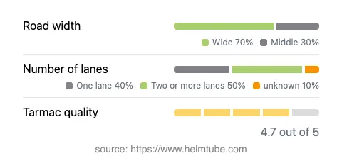
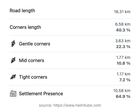
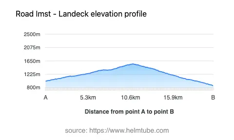
The Imst–Landeck route covers approximately 16.3 km (10.1 miles), with elevations ranging from 862 m (2,828 ft) to a maximum of 1,554 m (5,098 ft) at the Pillerhöhe Pass. The road surface is asphalt and is generally rated as excellent, providing a smooth ride for most of its length. Riders will encounter a mix of gently curved and moderately twisty sections, making it suitable for those seeking a balance between technical riding and relaxed touring. The road features predominantly wide lanes (about 70%), with the remainder split between middle-width and narrower segments. Most of the route (about 65%) passes through inhabited areas, which may affect traffic density and speed. The maximum speed limit varies between 30 km/h (19 mph) and 100 km/h (62 mph), depending on the section and proximity to settlements.
Pillerhöhe Pass and Surrounding Attractions
The highlight of this route is the ascent and descent over the Pillerhöhe Pass, a mountain pass at 1,559 m (5,115 ft) that is popular among motorcyclists for its panoramic viewpoints and access to the Kaunergrat Nature Park. The pass offers several vantage points, including a notable viewpoint recognized for its sweeping views of the surrounding Alps. The road also provides access to the Kaunergrat mountain range and the broader Alps region. Riders may wish to explore the nearby Oberes Gericht and Pillertal valleys, both of which are characteristic of Tyrol’s alpine geography and offer additional opportunities for sightseeing and outdoor activities.
Road Closures, Seasonal Access, and Practical Considerations
The Pillerhöhe Pass is generally open to motorcyclists throughout the year, but winter closures are possible due to snow and adverse weather conditions, typically from late autumn to early spring. Riders are advised to check local traffic reports or the ASFINAG traffic information service for current road status before planning a trip. There are no permanent restrictions for motorcycles, but temporary closures may occur during maintenance or special events. The road is not subject to a toll or entrance fee for motorcycles at present. However, toll conditions may change in the future, and riders should consult the ASFINAG toll information page for the latest updates on tolls and vignettes required for Austrian roads.
Planning Your Ride: Tips and Map
When planning a ride along the Imst–Landeck route via the Pillerhöhe Pass, it is advisable to consider weather conditions, especially outside the summer months. The road’s combination of wide lanes and high-quality asphalt makes it accessible for a range of motorcycles, though caution is recommended on twistier sections and during inclement weather. Both Imst and Landeck offer amenities for travelers, including fuel stations, accommodation, and dining options. For those interested in extending their journey, the region provides access to additional alpine passes and valleys. An interactive map of the Imst–Landeck route is available below to assist with navigation and trip planning.
Explore the Region: Roads Close By
Discover more amazing roads located near the route featured in this article. The list below highlights nearby routes that are perfect for extending your ride or planning your next adventure.
Ride the Best: Austria’s Top Motorcycle Roads
These are the best motorbiking roads in Austria. The list below shows links to articles about top-rated motorcycle routes in the country. Explore the most popular roads in Austria and plan your next unforgettable motorbike adventure.