Exploring the Rogaška Slatina–Plavić Route: A Motorcyclist’s Guide
Locals know best!
If you travel this road often or live close by you will be given a chance to provide your valuable rating soon! Sign in and stay connected.Location and Overview of the Rogaška Slatina–Plavić Road
The Rogaška Slatina–Plavić road is situated in eastern Slovenia, close to the border with Croatia. The route begins near the spa town of Rogaška Slatina and ends at the village of Plavić. The road passes through the settlements of Luke Poljanske, Harina Zlaka, and Bratkovec, following the meandering path of the Sotla (Sutla) River for much of its length. This area is characterized by gentle hills, agricultural landscapes, and a relatively low population density. An interactive map showing the route can be found at the end of this article.
Road Characteristics and Riding Experience
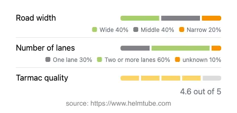
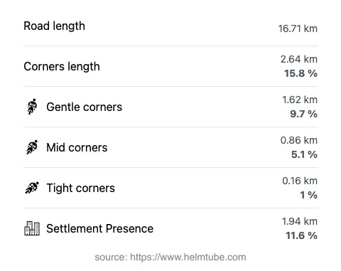
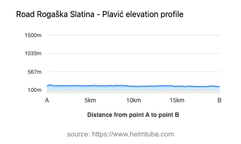
The Rogaška Slatina–Plavić road extends for approximately 16.7 km (10.4 miles), with an elevation range from 188 m (617 ft) to 235 m (771 ft). The road surface is asphalt and is generally of high quality, offering a smooth ride for most of its length. The route is not particularly twisty, with gentle curves dominating the alignment. About two-thirds of the road features two lanes, while the remainder is primarily single-lane. The width varies, with wide sections making up the largest proportion (about 43%), followed by middle-width and some narrower stretches. Only a small portion (11.6%) of the road passes through inhabited areas, contributing to a relatively uninterrupted riding experience. The proximity to the Sotla River (83% of the route) adds to the road’s appeal, providing frequent views of the waterway and the surrounding countryside.
Points of Interest Along the Route
The starting point near Rogaška Slatina is notable for its historic spa, which has attracted visitors for centuries due to its mineral-rich springs. The town itself offers a range of amenities, including accommodation, dining, and wellness facilities. Along the route, riders will pass through small settlements such as Luke Poljanske, Harina Zlaka, and Bratkovec, which provide glimpses into rural Slovenian life. The road closely follows the Sotla (Sutla) River, a natural border between Slovenia and Croatia, known for its biodiversity and tranquil scenery. The endpoint at Plavić is a small village, offering a quiet conclusion to the journey. For those interested in extending their ride, the region is also home to several vineyards and traditional farmsteads, which can be explored with short detours from the main route.
Practical Information: Closures, Tolls, and Regulations
There are currently no known restrictions or seasonal closures affecting motorcycles on the Rogaška Slatina–Plavić road. The route remains accessible throughout the year, although riders should be aware that weather conditions in winter may affect surface quality and traction. There are no tolls or entrance fees required to use this road. However, toll conditions may change in the future, and it is advisable to consult the official DARS website for the latest information on road tolls and regulations in Slovenia. Speed limits along the route vary, with posted limits of 30, 40, 50, and 60 km/h (19, 25, 31, and 37 mph) depending on the section and proximity to settlements. Riders are advised to observe local signage and adjust their speed accordingly, especially in inhabited areas and near river crossings.
Navigation and Further Resources
Navigation along the Rogaška Slatina–Plavić road is straightforward, with clear signage marking the main settlements and river crossings. The road is suitable for a range of motorcycles, from touring bikes to smaller displacement machines. For those seeking additional information about the region, resources such as Lonely Planet and Tripadvisor provide overviews of local attractions and amenities. An interactive map of the route is available at the end of this article, offering a visual guide to the road’s alignment and key points of interest.
Explore the Region: Roads Close By
Discover more amazing roads located near the route featured in this article. The list below highlights nearby routes that are perfect for extending your ride or planning your next adventure.
Ride the Best: Slovenia’s Top Motorcycle Roads
These are the best motorbiking roads in Slovenia. The list below shows links to articles about top-rated motorcycle routes in the country. Explore the most popular roads in Slovenia and plan your next unforgettable motorbike adventure.