Exploring Trögerner Straße: A Motorcyclist’s Guide through the Karawanken-Karavanke UNESCO Global Geopark
Locals know best!
If you travel this road often or live close by you will be given a chance to provide your valuable rating soon! Sign in and stay connected.Location and Geographic Context
Trögerner Straße is located in the southern part of Austria, within the state of Carinthia. The road passes through the Karawanken-Karavanke UNESCO Global Geopark, an area recognized for its geological diversity and cross-border significance. The route skirts the Petzen/Peca mountain range and crosses the broader Karavanke and Karawanken und Bachergebirge ranges, all of which are part of the Eastern Alps. The nearest town to the starting point is Bad Eisenkappel, situated just a short distance from the road’s entrance. The region is characterized by its mountainous terrain, forested landscapes, and proximity to the Austrian-Slovenian border. An interactive map showing the route of Trögerner Straße can be found at the end of this article.
Road Characteristics and Riding Experience
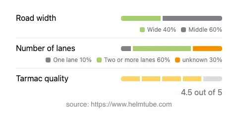
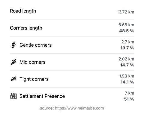
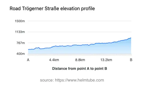
Trögerner Straße extends for approximately 13.7 km (8.5 miles), offering a moderately twisty ride with a curviness rating that suggests a mix of gentle and sharper bends. The road surface is asphalt and is generally of high quality, providing a smooth ride for most motorcycles. The width varies, with more than half of the route being of medium width (about 54%) and a significant portion classified as wide (about 40%), ensuring comfortable passage for two-way traffic. A small section (about 12%) is single-lane, which may require caution when encountering oncoming vehicles. The elevation ranges from 546 m (1,791 ft) at its lowest point to 933 m (3,061 ft) at its highest, offering moderate altitude changes without extreme gradients. The maximum speed limit is 30 km/h (19 mph), reflecting the road’s passage through protected and inhabited areas. Approximately half of the route traverses or borders inhabited zones, so riders should remain attentive to local traffic and pedestrians.
Natural Attractions and Points of Interest
One of the main highlights of Trögerner Straße is its passage through the Karawanken-Karavanke UNESCO Global Geopark. This geopark is known for its geological formations, diverse flora and fauna, and educational trails. The road also provides access to the Trögerner Klamm, a gorge renowned for its dramatic rock formations and hiking opportunities. The proximity to the Petzen mountain range offers additional outdoor activities, including hiking and caving. The broader Karavanke range is a significant natural barrier between Austria and Slovenia, and its presence is felt throughout the journey. These attractions make the route appealing not only for motorcyclists but also for those interested in geology and nature.
Road Closures and Seasonal Considerations
Trögerner Straße is subject to certain restrictions due to its location within a UNESCO Global Geopark and its proximity to protected natural areas. There are no permanent closures for motorcycles reported, but temporary closures may occur due to maintenance, weather conditions, or local events. The road may be closed or have limited access during winter months, especially in case of heavy snowfall or adverse weather, as is common in alpine regions. Riders are advised to check local sources or the Karawanken-Karavanke UNESCO Global Geopark website for up-to-date information on accessibility before planning their trip.
Tolls, Fees, and Practical Information
Currently, there are no tolls or entrance fees specifically for using Trögerner Straße. However, as the road passes through a geopark and protected areas, regulations and fee structures may change in the future. Riders should consult the ASFINAG website for the latest information on tolls and vignettes required for Austrian roads. It is important to note that while Trögerner Straße itself is not a major highway, general Austrian road regulations apply, and compliance with posted speed limits and environmental guidelines is mandatory.
Explore the Region: Roads Close By
Discover more amazing roads located near the route featured in this article. The list below highlights nearby routes that are perfect for extending your ride or planning your next adventure.
Ride the Best: Austria’s Top Motorcycle Roads
These are the best motorbiking roads in Austria. The list below shows links to articles about top-rated motorcycle routes in the country. Explore the most popular roads in Austria and plan your next unforgettable motorbike adventure.