Riding the Paulitschsattel Pass Road: A Motorcyclist’s Guide Through the Karawanken-Karavanke Geopark
Locals know best!
If you travel this road often or live close by you will be given a chance to provide your valuable rating soon! Sign in and stay connected.Location and Geographic Context
The Paulitschsattel Straße is situated in southern Austria, within the state of Carinthia, and connects the area near Bad Eisenkappel/Železna Kapla to the Paulitschsattel mountain pass. The road forms part of the border region with Slovenia and is embedded in the Karawanken-Karavanke UNESCO Global Geopark, an area recognized for its geological diversity and cross-border cooperation. The route crosses the Kamniško-Savinjske Alpe and skirts the Karavanke and Karawanken und Bachergebirge mountain ranges, providing a varied alpine landscape. An interactive map showing the road’s course can be found at the end of this article.
Road Characteristics and Riding Experience
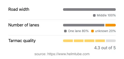
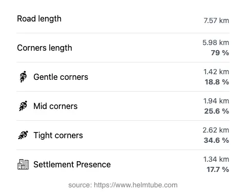
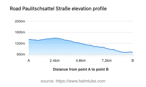
The Paulitschsattel Pass Road extends for approximately 7.6 km (4.7 miles), with an elevation gain from 876 m (2,874 ft) to a maximum of 1,396 m (4,580 ft). The road surface is asphalt and is generally of good quality, with most sections rated as smooth and well-maintained. The route is characterized by a very twisty alignment, offering a series of technical curves that demand attention and skill from riders. The road is predominantly of medium width (about 100%), with the majority of the route consisting of a single lane in each direction (about 83%). The remaining sections are narrow, requiring caution, especially when encountering oncoming traffic. Only a small proportion of the road (17.7%) passes through inhabited areas, with the majority traversing forested and mountainous terrain. The ascent to the Paulitschsattel (Pavličevo sedlo) is a highlight, providing both a physical and visual transition between valleys and mountain ranges.
Natural Attractions and Points of Interest
One of the defining features of the Paulitschsattel Pass Road is its passage through the Karawanken-Karavanke UNESCO Global Geopark. This geopark is renowned for its unique geological formations, cross-border hiking trails, and educational sites. The road also runs along the Kotschnatal valley for nearly half its length, offering views of alpine meadows and forested slopes. Motorcyclists will find several viewpoints along the route, providing opportunities to stop and appreciate the surrounding Kamniško-Savinjske Alpe and Karavanke ranges. The proximity to Bad Eisenkappel/Železna Kapla, a town known for its spa and mineral springs, adds another layer of interest for those wishing to explore local culture and history. For more information about the region’s geological and natural attractions, the Karawanken-Karavanke UNESCO Global Geopark website offers detailed resources.
Seasonal Accessibility and Road Regulations
The Paulitschsattel Pass Road is subject to seasonal closures due to snow and adverse weather conditions, typically during the winter months. Motorcyclists should verify current road status before planning a trip, as closures can vary depending on snowfall and maintenance schedules. There are no permanent restrictions for motorcycles, but riders should be aware of potential temporary closures for maintenance or local events. The road is not a major transit route, so traffic is generally light, but caution is advised on narrow and twisty sections, especially in poor weather or during peak tourist periods.
Tolls, Fees, and Further Information
Currently, there is no toll or entrance fee required to ride the Paulitschsattel Pass Road. However, toll conditions may change in the future, and it is advisable to consult official Austrian road authorities for the most up-to-date information. For general information about road tolls and entrance fees in Austria, visit the ASFINAG Vignette Information page. Riders should also be aware that the road passes through a protected geopark area, and local regulations regarding environmental protection and parking may apply.
Explore the Region: Roads Close By
Discover more amazing roads located near the route featured in this article. The list below highlights nearby routes that are perfect for extending your ride or planning your next adventure.
Ride the Best: Austria’s Top Motorcycle Roads
These are the best motorbiking roads in Austria. The list below shows links to articles about top-rated motorcycle routes in the country. Explore the most popular roads in Austria and plan your next unforgettable motorbike adventure.