Weißenbacher Sattel Pass Road: Motorcycling Through the Salzkammergut Mountains
Locals know best!
If you travel this road often or live close by you will be given a chance to provide your valuable rating soon! Sign in and stay connected.Location and Regional Context
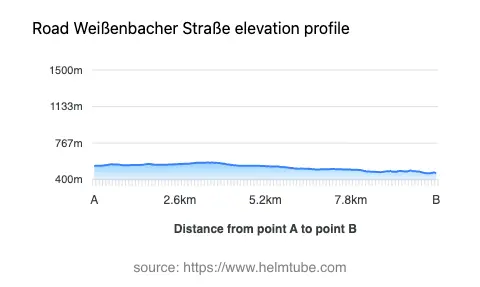
The Weißenbacher Sattel Pass Road is situated in Upper Austria, connecting the area near the town of Bad Ischl with the Weißenbachtal valley. The route lies within the Salzkammergut region, an area renowned for its lakes, mountains, and historic spa towns. The road itself serves as a connector between the northern and southern parts of the Salzkammergut-Berge, passing through the Weißenbachtal and over the Weißenbacher Sattel at an elevation of 566 m (1,857 ft). The proximity to Bad Ischl, a town famous for its imperial history and spa culture, adds to the road’s appeal for touring motorcyclists. An interactive map showing the route of the Weißenbacher Sattel Pass Road can be found at the end of this article.
Road Characteristics and Riding Experience
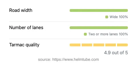
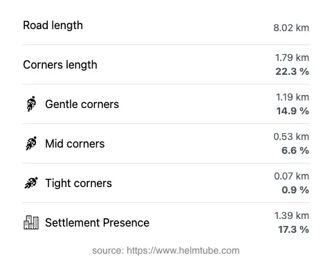
The Weißenbacher Sattel Pass Road extends for approximately 8 km (5 miles), with the entire length surfaced in high-quality asphalt. The road is wide for its entire stretch (about 90%), providing ample space for maneuvering and overtaking. The route is characterized by gently curved sections, making it accessible for riders of varying skill levels, while still offering enough variation to maintain interest. The elevation ranges from 463 m (1,519 ft) at its lowest point to 572 m (1,877 ft) at its highest, with the Weißenbacher Sattel itself reaching 566 m (1,857 ft). The road passes through predominantly uninhabited areas, with only about 17% of its length traversing settlements. Speed limits vary along the route, with sections posted at 100 km/h (62 mph), 70 km/h (43 mph), and 50 km/h (31 mph), reflecting changes in road environment and proximity to inhabited areas.
Natural Features and Surrounding Attractions
The Weißenbacher Sattel Pass Road is notable for its passage through the Weißenbachtal valley, a corridor flanked by the Salzkammergut-Berge and Höllengebirge mountain ranges. The Salzkammergut-Berge, part of the Northern Limestone Alps, are known for their rugged limestone peaks and forested slopes (Salzkammergut Berge). The Höllengebirge, whose name translates as "Mountains of Hell," are equally dramatic and form a striking backdrop to the ride (Höllengebirge). The region is also home to several lakes, including the nearby Attersee and Wolfgangsee, both popular destinations for outdoor recreation. Bad Ischl, located near the starting and ending points of the road, is a historic spa town with connections to the Habsburg monarchy (Bad Ischl). These features make the Weißenbacher Sattel Pass Road a gateway to some of Austria’s most distinctive alpine landscapes and cultural sites.
Road Closures and Seasonal Considerations
The Weißenbacher Sattel Pass Road is generally open to motorcyclists throughout the year. However, as with many alpine routes in Austria, temporary closures can occur due to adverse weather conditions, particularly in winter months when snow or ice may make the road impassable. There are no permanent restrictions on motorcycle access. Riders are advised to check local traffic information or the ASFINAG traffic information service for up-to-date details on closures or roadworks before planning their journey.
Tolls, Fees, and Practical Information
There is currently no toll or entrance fee required to ride the Weißenbacher Sattel Pass Road. However, toll conditions in Austria may change, and it is advisable to consult official sources for the most current information. For general details on road tolls and vignettes in Austria, riders can refer to the ASFINAG vignette information page. Fuel, food, and accommodation are available in nearby towns such as Bad Ischl, making the route suitable for both day trips and longer touring itineraries.
Explore the Region: Roads Close By
Discover more amazing roads located near the route featured in this article. The list below highlights nearby routes that are perfect for extending your ride or planning your next adventure.
Ride the Best: Austria’s Top Motorcycle Roads
These are the best motorbiking roads in Austria. The list below shows links to articles about top-rated motorcycle routes in the country. Explore the most popular roads in Austria and plan your next unforgettable motorbike adventure.