Motorcycling the Tulln an der Donau – Purkersdorf Route: Through the Heart of the Wienerwald
Locals know best!
If you travel this road often or live close by you will be given a chance to provide your valuable rating soon! Sign in and stay connected.Location and Overview
The Tulln an der Donau – Purkersdorf route is situated in Lower Austria, west of Vienna. It begins near the historic town of Tulln an der Donau and concludes in the town of Purkersdorf, on the edge of the Vienna metropolitan area. The road cuts through the northern section of the Wienerwald (Vienna Woods), a low mountain range that forms the northeastern foothills of the Alps. This area is characterized by rolling hills, dense forests, and a patchwork of small settlements. An interactive map showing the route can be found at the end of the article.
Road Details and Riding Experience
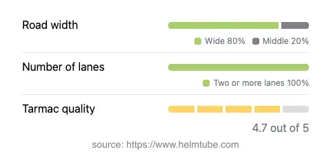
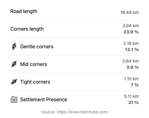
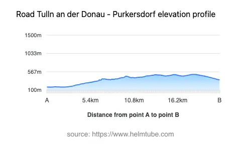
The route covers approximately 16.5 km (10.3 miles), with elevations ranging from 177 m (581 ft) to 502 m (1,647 ft). The road surface is asphalt and is generally of high quality, offering a smooth ride for most of its length. The majority of the road is wide (about 77%), with a smaller proportion being of medium width (17%) and only a minor section considered narrow (4%). Most of the route features two lanes (about 96%), ensuring comfortable passage for both local and through traffic. The road is moderately curvy, providing enough bends to keep the ride engaging without being overly technical. Speed limits vary along the route, with sections posted at 30, 50, 70, and 100 km/h (19, 31, 43, and 62 mph), reflecting the transition between inhabited areas and open countryside. About 31% of the road passes through towns or villages, including stretches along Neuwaldegger Straße, Tullnerstraße, Tullner Straße, Wiener Straße, Tulbinger Straße, and Hauptplatz.
Local Attractions and Points of Interest
This route is notable for its proximity to several attractions unique to the region. Tulln an der Donau, the starting point, is renowned for its Roman history and the Tulln Garden exhibitions. As the road enters the Vienna Woods, riders can experience the tranquil forested landscapes that have inspired artists and writers for centuries. Purkersdorf, at the route’s end, is known for its Jugendstil (Art Nouveau) architecture, particularly the Purkersdorf Sanatorium. The road also provides access to hiking trails and viewpoints within the Wienerwald, making it a popular choice for those combining motorcycling with outdoor activities.
Road Closures and Seasonal Considerations
The Tulln an der Donau – Purkersdorf route is a public road and remains open to motorcycles throughout the year. There are no regular seasonal closures, although temporary restrictions may occur due to roadworks or local events. Winter conditions can affect the higher sections of the route, particularly in the Wienerwald, where snow and ice may be present. Riders are advised to check local traffic updates before setting out, especially during the colder months. For current information on road conditions and closures in Austria, consult the ASFINAG Traffic Reports.
Tolls, Fees, and Practical Information
There are no tolls or entrance fees required to ride the Tulln an der Donau – Purkersdorf route. However, toll conditions in Austria may change in the future, particularly for certain classes of vehicles or for the use of motorways and expressways. For the most up-to-date information on road tolls and vignettes in Austria, refer to the ASFINAG Vignette Information page. Riders should also be aware of local traffic regulations and speed limits, which are strictly enforced throughout the region.
Explore the Region: Roads Close By
Discover more amazing roads located near the route featured in this article. The list below highlights nearby routes that are perfect for extending your ride or planning your next adventure.
Ride the Best: Austria’s Top Motorcycle Roads
These are the best motorbiking roads in Austria. The list below shows links to articles about top-rated motorcycle routes in the country. Explore the most popular roads in Austria and plan your next unforgettable motorbike adventure.