Exploring the Tulln an der Donau – Purkersdorf Route: A Motorcyclist’s Guide
Locals know best!
If you travel this road often or live close by you will be given a chance to provide your valuable rating soon! Sign in and stay connected.Location and Geographic Context
The Tulln an der Donau – Purkersdorf route is situated in Lower Austria, running west of Vienna. The road begins near the historic town of Tulln an der Donau and concludes at Purkersdorf, a gateway to the Vienna Woods. The route traverses the foothills of the Alps and passes through the Wienerwald (Vienna Woods), a region known for its forested hills and proximity to the Austrian capital. The road also skirts the Jammertal valley, offering a blend of rural and semi-urban landscapes. An interactive map showing the route is available at the end of this article.
Road Characteristics and Riding Experience
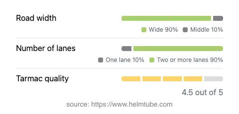
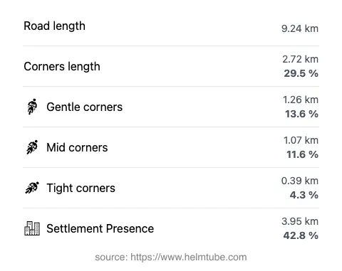
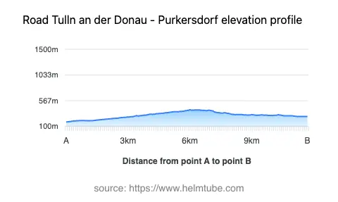
This 9.2 km (5.7 miles) stretch is predominantly wide (about 90%) and features two lanes for most of its length (about 88%), with a small portion narrowing to a single lane. The surface is asphalt and generally rated as very good, providing a smooth ride with minimal irregularities. The road’s alignment is moderately curvy, offering a mix of gently curved and straight sections, making it suitable for riders seeking a relaxed yet engaging journey. The elevation ranges from 182 m (597 ft) to 404 m (1,325 ft), with the route ascending and descending through the foothills of the Alps and the Vienna Woods. Approximately 42.8% of the road passes through inhabited areas, including settlements such as Wienerstraße, An der Zeil, Allhangstraße, Hirschengartenstraße, and Hauptplatz. The remainder of the route offers a more rural and forested environment, particularly as it crosses the Jammertal valley and the wooded hills of the Wienerwald.
Speed Limits, Traffic, and Seasonal Considerations
Speed limits along the Tulln an der Donau – Purkersdorf route vary between 50 km/h (31 mph), 60 km/h (37 mph), and 70 km/h (43 mph), depending on the proximity to settlements and road conditions. The road is open year-round and is not subject to seasonal closures for motorcycles. However, riders should be aware that winter conditions in the Wienerwald can lead to slippery surfaces, especially in shaded or forested sections. There are no known event-related closures affecting this route. Traffic volumes can increase during commuter hours, particularly near Purkersdorf and Tulln an der Donau, but the road generally remains accessible for motorcyclists throughout the year.
Tolls, Fees, and Practical Information
There are currently no tolls or entrance fees required to ride the Tulln an der Donau – Purkersdorf route. Riders should note that toll conditions may change in the future, especially if regional infrastructure policies are updated. For the most current information on road tolls and fees in Austria, consult the official ASFINAG website. Standard Austrian traffic regulations apply, and motorcyclists are advised to carry all necessary documentation and safety equipment as required by national law.
Points of Interest and Attractions Along the Route
The route offers access to several notable attractions. Tulln an der Donau is renowned for its Roman heritage and the Egon Schiele Museum, dedicated to the famous Austrian painter. The road’s passage through the Wienerwald provides opportunities for detours into forested hiking trails and nature reserves. Purkersdorf, at the eastern end of the route, is known for its Jugendstil architecture and proximity to the Purkersdorf Sanatorium, a significant example of early modernist design. The Jammertal valley, though less widely known, offers a tranquil landscape for those interested in exploring the quieter corners of the Vienna Woods. Riders seeking a blend of cultural and natural attractions will find this route offers convenient access to both.
Explore the Region: Roads Close By
Discover more amazing roads located near the route featured in this article. The list below highlights nearby routes that are perfect for extending your ride or planning your next adventure.
Ride the Best: Austria’s Top Motorcycle Roads
These are the best motorbiking roads in Austria. The list below shows links to articles about top-rated motorcycle routes in the country. Explore the most popular roads in Austria and plan your next unforgettable motorbike adventure.