Exploring the Wipptal Route: Innsbruck to Matrei am Brenner by Motorcycle
Locals know best!
If you travel this road often or live close by you will be given a chance to provide your valuable rating soon! Sign in and stay connected.Location and Overview of the Wipptal Route
The Wipptal Route runs between the city of Innsbruck and the town of Matrei am Brenner in the Austrian state of Tyrol. The road closely follows the Sill River for much of its length, passing through the Wipptal valley and intersecting with several other valleys, including the Stubaital and Viggartal. The route is situated within the Alps, specifically crossing sections of the Nördliche Stubaier Alpen, Kalkkögel, Schrankogelgruppe, Habicht-Serles-Kamm, and Serleskamm mountain ranges. This corridor serves as a key connection between northern and southern Tyrol, with the majority of the road running through inhabited areas and offering access to local settlements such as Mühlbachl and Stefansbrücke. An interactive map showing the route can be found at the end of the article.
Road Characteristics and Riding Experience
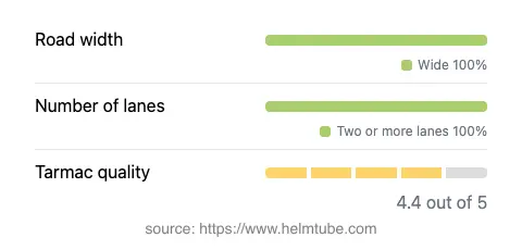
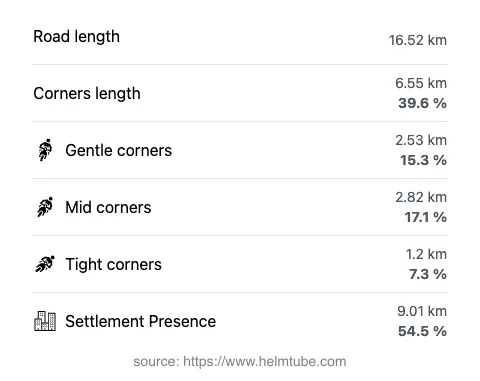
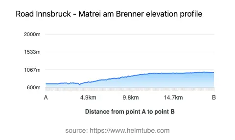
The Wipptal Route covers approximately 16.5 km (10.3 miles) between Innsbruck and Matrei am Brenner. The road surface is asphalt and is generally rated as very good, providing a comfortable ride for most motorcycles. The route is predominantly wide (about 90%), with two lanes for the vast majority of its length, ensuring smooth traffic flow and ample space for overtaking. Only a small portion is of medium width, and narrow sections are virtually nonexistent. The road is moderately curvy, offering a mix of gently sweeping bends and some tighter turns, but it is not extremely twisty. Elevation ranges from 680 m (2,231 ft) at its lowest point to 1,008 m (3,307 ft) at its highest, with the route running through the Wipptal valley and adjacent to the Sill River for about two-thirds of its length. Speed limits vary along the route, typically ranging from 50 km/h (31 mph) to 100 km/h (62 mph), depending on the section and proximity to settlements.
Natural Features and Attractions Along the Route
The Wipptal Route is notable for its proximity to several natural features. The Sill River, a tributary of the Inn, accompanies the road for much of the journey, providing a constant presence of water and lush riverside scenery. The road also passes through or near the Stubaital, Viggartal, and Arztal valleys, each offering distinct alpine landscapes. The Wipptal valley itself is a defining feature of the route, shaping both the geography and the riding experience. The surrounding Alps, including the Nördliche Stubaier Alpen and Kalkkögel, create a dramatic backdrop. While the road is not a dedicated mountain pass, it does cross significant alpine terrain. There are several viewpoints along the route, allowing riders to pause and appreciate the mountain vistas and valley landscapes. For those interested in exploring further, the nearby Stubaital and Wipptal valleys are popular destinations for outdoor activities.
Seasonal Closures, Road Tolls, and Practical Information
The Wipptal Route between Innsbruck and Matrei am Brenner is a primary road and remains open to motorcycles throughout the year, except in cases of temporary closures due to roadworks or severe weather conditions. There are no regular seasonal closures specific to this section, but riders should be aware that winter conditions in the Alps can affect road safety and accessibility. There is currently no toll or entrance fee required for motorcycles on this route. However, toll conditions in Austria may change, and it is advisable to check the latest information before traveling. For up-to-date details on road tolls and regulations in Austria, consult the official ASFINAG toll information website. Riders should also be mindful of local speed limits and traffic regulations, especially when passing through inhabited areas, which make up more than half of the route.
Planning Your Motorcycle Journey
When planning a motorcycle trip along the Wipptal Route, consider the variable speed limits and the mix of urban and rural environments. The road’s high surface quality and wide lanes make it suitable for both experienced and less experienced riders. The proximity to the Sill River and the surrounding valleys provides opportunities for short detours and exploration. Innsbruck, as the nearest major city, offers a range of services, accommodations, and cultural attractions, while Matrei am Brenner serves as a gateway to further alpine adventures. For those interested in extending their ride, the route connects easily to other notable roads and passes in the Tyrol region. An interactive map of the Wipptal Route is available below to assist with navigation and trip planning.
Explore the Region: Roads Close By
Discover more amazing roads located near the route featured in this article. The list below highlights nearby routes that are perfect for extending your ride or planning your next adventure.
Ride the Best: Austria’s Top Motorcycle Roads
These are the best motorbiking roads in Austria. The list below shows links to articles about top-rated motorcycle routes in the country. Explore the most popular roads in Austria and plan your next unforgettable motorbike adventure.