Turracher Höhe Pass (Turracher Höhe): A Technical Overview for Motorcyclists
Locals know best!
If you travel this road often or live close by you will be given a chance to provide your valuable rating soon! Sign in and stay connected.Location and Geographic Context
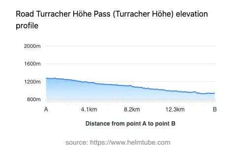
Turracher Höhe Pass (Turracher Höhe) is situated in Austria, connecting the village of Turrach with the town of Tamsweg. The road forms part of the Turracher Straße and crosses the Gurktaler Alpen, a subrange of the Alps. The pass is positioned at elevations ranging from 929 m (3,048 ft) to 1,281 m (4,203 ft), offering a route through alpine terrain. The surrounding region is characterized by mountainous landscapes and proximity to the broader Alps, making it a significant corridor for both local and touring traffic. An interactive map showing the road can be found at the end of the article.
Road Characteristics and Riding Experience
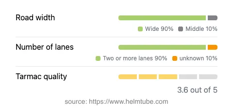
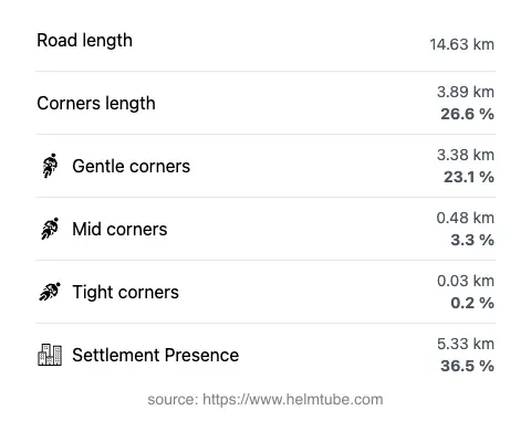
The Turracher Höhe Pass extends for approximately 14.6 km (9.1 miles), with the majority of the route (about 90%) classified as wide and two-lane, providing ample space for maneuvering. The road surface is asphalt, with a quality rating that can be described as above average but not excellent. Riders will encounter a gently curved alignment, offering a moderate level of technical challenge suitable for a range of skill levels. The maximum speed limit along the pass is 70 km/h (43 mph), reflecting the road's design and the need for caution in alpine conditions. Approximately 36.5% of the route passes through inhabited areas, which may require additional attention to local traffic and potential hazards. The pass is a crossing point for several mountain ranges, including the Gurktal Alps and the broader Alps, further enhancing its appeal for those interested in alpine riding.
Seasonal Accessibility and Road Closures
Turracher Höhe Pass is generally open to motorcyclists throughout the year, but winter conditions can lead to temporary closures or restrictions due to snow and ice. The pass is situated at a relatively high elevation, and snowfall can be significant during the colder months. It is common for the road to be closed or require the use of snow chains during periods of heavy snow, typically from late autumn to early spring. There are no regular event-related closures reported, but riders are advised to check local traffic updates before planning a journey, especially outside the summer season. For current road status, the ASFINAG Traffic Information service provides up-to-date details on closures and conditions.
Tolls, Fees, and Practical Information
There is currently no dedicated toll or entrance fee for motorcycles using the Turracher Höhe Pass. However, as with many Austrian roads, toll conditions may change in the future, and it is advisable to verify the latest requirements before travel. For comprehensive information on road tolls and vignette requirements in Austria, consult the ASFINAG Vignette page. Riders should also be aware that certain sections of the Austrian road network may require a vignette or separate toll payment, particularly for motorways and expressways, though this does not currently apply to the Turracher Höhe Pass.
Nearby Settlements and Points of Interest
The pass begins near the village of Turrach and ends close to the town of Tamsweg, both of which offer basic amenities and accommodation options for travelers. The region is known for its alpine scenery and outdoor activities, including hiking and winter sports. While the road itself is primarily a transit route, the surrounding Gurktaler Alpen provide opportunities for exploration and relaxation. For those interested in learning more about the mountain range, the Gurktal Alps entry offers additional background. An interactive map of the Turracher Höhe Pass is available below for route planning and navigation purposes.
Explore the Region: Roads Close By
Discover more amazing roads located near the route featured in this article. The list below highlights nearby routes that are perfect for extending your ride or planning your next adventure.
Ride the Best: Austria’s Top Motorcycle Roads
These are the best motorbiking roads in Austria. The list below shows links to articles about top-rated motorcycle routes in the country. Explore the most popular roads in Austria and plan your next unforgettable motorbike adventure.