Exploring the Ybbstaler Alpen Route: Sankt Georgen am Reith to Waidhofen an der Ybbs
Locals know best!
If you travel this road often or live close by you will be given a chance to provide your valuable rating soon! Sign in and stay connected.Location and Overview of the Ybbstaler Alpen Route
The Ybbstaler Alpen Route runs between the village of Sankt Georgen am Reith and the town of Waidhofen an der Ybbs in Lower Austria. The road passes through several settlements, including Große Kripp, In der Noth, Eisenstraße, Markt, Brücke über die Schwarze Ois, and Prollingbachbrücke. This area is situated within the Ybbstaler Alpen, a subrange of the Northern Limestone Alps, and is characterized by its proximity to the Prolling valley. The route is well-positioned for riders looking to experience the less-traveled sections of the Austrian Alps. An interactive map showing the road can be found at the end of the article.
Road Characteristics and Riding Experience
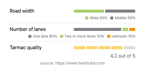
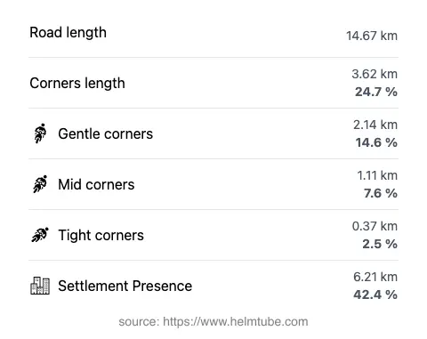
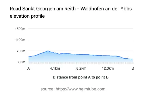
The Ybbstaler Alpen Route extends for approximately 14.7 km (9.1 miles), offering a ride that is gently curved rather than highly twisty. The road surface is asphalt and is generally of good quality, with most sections rated as smooth and well-maintained. Riders will encounter a mix of road widths, with about 90% of the route being of middle or wide width, and the majority of the road consisting of one lane in each direction. The elevation ranges from 414 m (1,358 ft) at its lowest point to 705 m (2,313 ft) at its highest, providing moderate altitude changes suitable for a relaxed yet engaging ride. The route passes through inhabited areas for roughly 42% of its length, offering occasional glimpses of local village life.
Natural Features and Points of Interest
This road is notable for its passage through the Prolling valley, which accounts for about 60% of the route. The surrounding landscape is defined by the Ybbstaler Alpen, a region known for its forested slopes and limestone formations. Along the way, riders will find several viewpoints that offer opportunities to pause and appreciate the alpine scenery. The route also crosses the Schwarze Ois river, adding to the variety of natural features encountered. For those interested in learning more about the region, the Ybbstaler Alpen are well-documented for their hiking and outdoor recreation opportunities.
Traffic, Speed Limits, and Seasonal Considerations
The Ybbstaler Alpen Route is subject to varying speed limits, with posted limits of 70 km/h (43 mph), 50 km/h (31 mph), and 30 km/h (19 mph) depending on the section and proximity to settlements. The road is open to motorcycles and is not known for any permanent closures specific to two-wheeled vehicles. However, as with many alpine routes in Austria, temporary closures may occur due to weather conditions, particularly in winter months when snow or ice can make travel hazardous. Riders are advised to check local traffic updates before planning their journey.
Tolls, Fees, and Practical Information
There are currently no tolls or entrance fees required to ride the Ybbstaler Alpen Route. However, toll conditions in Austria may change, and it is recommended to consult official resources for the most up-to-date information. For details on road tolls and vignette requirements in Austria, refer to the ASFINAG vignette information page. Riders should also be aware of general Austrian road regulations, including the requirement for daytime running lights and the use of appropriate safety gear.
Explore the Region: Roads Close By
Discover more amazing roads located near the route featured in this article. The list below highlights nearby routes that are perfect for extending your ride or planning your next adventure.
Ride the Best: Austria’s Top Motorcycle Roads
These are the best motorbiking roads in Austria. The list below shows links to articles about top-rated motorcycle routes in the country. Explore the most popular roads in Austria and plan your next unforgettable motorbike adventure.