Exploring the Žalec–Velenje Alpine Route: A Motorcyclist’s Guide
Locals know best!
If you travel this road often or live close by you will be given a chance to provide your valuable rating soon! Sign in and stay connected.Location and Geographic Context
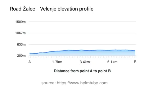
The Žalec–Velenje road is situated in northern Slovenia, connecting the town of Žalec to Velenje. The route lies within the broader Alpine region, intersecting the Alps and the Karavanke mountain ranges. This area is characterized by rolling hills, forested slopes, and a mix of rural and urban landscapes. The road’s proximity to these mountain ranges provides a unique backdrop, with elevations ranging from 284 m (932 ft) to 426 m (1,398 ft). An interactive map showing the exact route can be found at the end of this article.
Road Details and Riding Experience
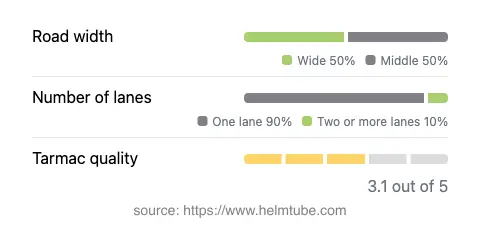
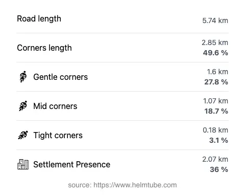
The Žalec–Velenje route extends for approximately 5.7 km (3.5 miles), offering a moderately curvy ride suitable for a range of motorcycling skill levels. The road surface is asphalt, with a surface quality rated as average. Riders will encounter a mix of road widths, with about half of the route being wide and the remainder of medium width. The majority of the road consists of a single lane (about 90%), with a small portion featuring two lanes. The route passes through both inhabited and rural areas, with roughly one-third of the distance traversing settlements. This combination of features makes the road a practical connector rather than a destination for technical riding, but it remains an interesting option for those exploring the region.
Mountain Ranges and Natural Attractions
One of the defining characteristics of this road is its passage through the foothills of the Alps and the Karavanke. While the route does not reach high alpine elevations, it provides access to the landscapes typical of these ranges. The nearby town of Velenje is known for Velenje Castle, a notable local attraction. The region is also recognized for its green hills and agricultural heritage, particularly around Žalec, which is famous for its hop-growing tradition and the unique Beer Fountain. These attractions provide additional points of interest for riders looking to combine their journey with cultural or historical stops.
Road Closures and Seasonal Considerations
There are no known permanent closures for motorcycles on the Žalec–Velenje road. The route remains open throughout the year, as it does not ascend to high elevations where winter closures are common. However, temporary closures may occur due to roadworks or local events. Riders are advised to check local traffic updates before departure, especially during periods of adverse weather or construction activity.
Tolls, Fees, and Practical Information
The Žalec–Velenje road does not currently require a toll or entrance fee for motorcycles. Riders should be aware that toll conditions may change in the future, and it is advisable to consult official resources for the most up-to-date information. For details on road tolls and vignettes in Slovenia, refer to the official DARS website. Standard speed limits apply, with urban sections typically limited to 50 km/h (31 mph) and rural stretches allowing up to 90 km/h (56 mph), unless otherwise indicated by road signs.
Explore the Region: Roads Close By
Discover more amazing roads located near the route featured in this article. The list below highlights nearby routes that are perfect for extending your ride or planning your next adventure.
Ride the Best: Slovenia’s Top Motorcycle Roads
These are the best motorbiking roads in Slovenia. The list below shows links to articles about top-rated motorcycle routes in the country. Explore the most popular roads in Slovenia and plan your next unforgettable motorbike adventure.