Exploring the Slovenj Gradec – Velenje Alpine Route: A Motorcyclist’s Guide
Locals know best!
If you travel this road often or live close by you will be given a chance to provide your valuable rating soon! Sign in and stay connected.Location and Regional Context
The Slovenj Gradec – Velenje Alpine Route is situated in northern Slovenia, linking the towns of Slovenj Gradec and Velenje. The road passes through several settlements, including Paka pri Velenju, Završe, Šaleška cesta, Movže, Gornji Dolič, Šentlenart, Kozjak, and Straže. This corridor crosses the eastern fringes of the Alps and the Karavanke, providing a transition between the hilly terrain and the more urbanized valleys. The proximity to both towns makes it a frequently used route for local traffic as well as touring motorcyclists. An interactive map showing the road can be found at the end of the article.
Road Characteristics and Riding Experience
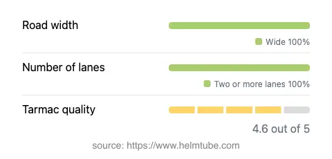
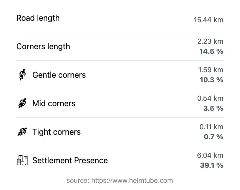
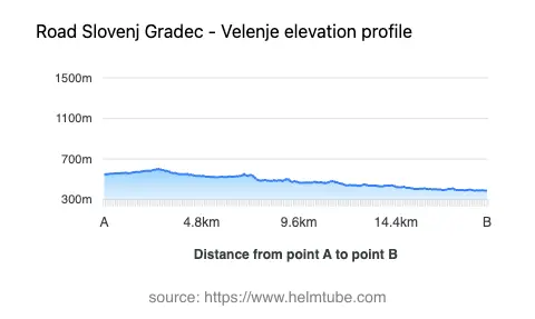
The route covers a distance of approximately 15.4 km (9.6 miles), with elevations ranging from 389 m (1,276 ft) to 604 m (1,982 ft). The road is predominantly wide (about 98%), with two lanes throughout its length (about 100%). The surface is asphalt and is generally rated as very good, offering a smooth ride for motorcycles. The road is gently curved, making it suitable for riders who prefer a less demanding, more relaxed journey. About 39% of the route passes through inhabited areas, so riders should expect occasional local traffic and observe posted speed limits. The maximum speed permitted is 50 km/h (31 mph), which is typical for roads passing through settlements and hilly terrain.
Mountain Ranges and Natural Features
This road is notable for crossing the outer edges of the Alps and the Karavanke mountain ranges. While the elevations are moderate compared to the high Alpine passes, the surrounding landscape is characterized by rolling hills, forested slopes, and occasional views of higher peaks in the distance. The route does not traverse any major mountain pass but serves as a connector between valleys, making it a practical option for riders heading towards more mountainous regions or exploring the local countryside. The area is also known for its proximity to the Velenje Castle, a notable landmark near the southern end of the route.
Road Closures, Tolls, and Seasonal Considerations
The Slovenj Gradec – Velenje Alpine Route is open to motorcycles year-round, with no regular seasonal closures. Temporary closures may occur due to roadworks or local events, but these are typically announced in advance by local authorities. There are currently no tolls or entrance fees required to use this road. Riders should be aware that toll conditions may change in the future. For up-to-date information on road tolls and entrance fees in Slovenia, consult the official DARS website.
Points of Interest and Rider Amenities
Along the route, riders will pass through several small settlements, each offering opportunities for short stops and refreshments. The town of Slovenj Gradec is known for its medieval old town and cultural sites, while Velenje features the Velenje Castle and the Velenje Lake. These locations provide both historical interest and recreational opportunities for travelers. Fuel stations and basic services are available in both towns, ensuring that riders can prepare for longer journeys into the surrounding mountains or continue their exploration of northern Slovenia.
Explore the Region: Roads Close By
Discover more amazing roads located near the route featured in this article. The list below highlights nearby routes that are perfect for extending your ride or planning your next adventure.
Ride the Best: Slovenia’s Top Motorcycle Roads
These are the best motorbiking roads in Slovenia. The list below shows links to articles about top-rated motorcycle routes in the country. Explore the most popular roads in Slovenia and plan your next unforgettable motorbike adventure.