Exploring the 657 Petrina–Osilnica Road: A Motorcyclist’s Guide Along the Kupa River
Locals know best!
If you travel this road often or live close by you will be given a chance to provide your valuable rating soon! Sign in and stay connected.Location and Route Overview
The 657 Petrina–Osilnica road is situated in southern Slovenia, running parallel to the Kupa River for the majority of its length. The route connects the settlements of Petrina and Osilnica, passing through Grivac and lying close to the Croatian border. The nearest larger towns are Delnice, located approximately 8.4 km (5.2 miles) from the starting point, and Čabar, about 7.8 km (4.8 miles) from the endpoint. The road’s proximity to the Kupa River, a significant waterway that ultimately joins the Sava, defines much of its character. An interactive map showing the road’s course can be found at the end of this article.
Road Characteristics and Riding Experience
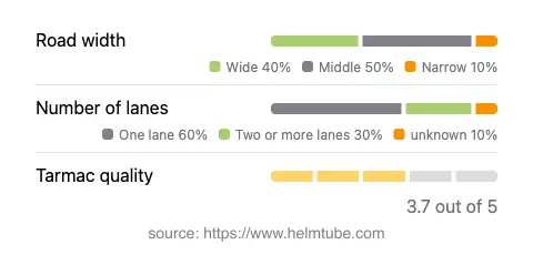
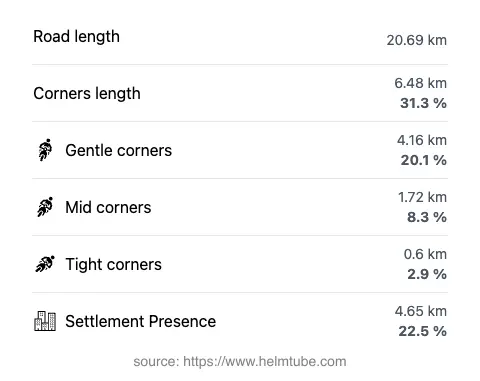
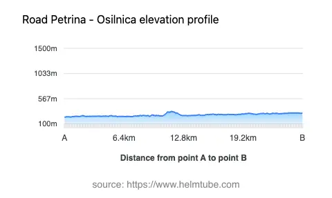
The 657 Petrina–Osilnica road extends for approximately 20.7 km (12.9 miles), with a moderate level of curviness that will appeal to riders seeking a balance between relaxed cruising and engaging turns. The road surface is asphalt, with a quality rating that can be described as generally good, though not without occasional imperfections. Riders will encounter a mix of lane configurations: the majority of the route features a single lane (about 59%), while two-lane sections account for roughly 30%. In terms of width, the road is predominantly of medium width (about 48%), with wide sections making up a significant portion (about 39%), and only a small fraction being narrow. Elevation varies modestly, ranging from 226 m (741 ft) to 333 m (1,093 ft), ensuring a gentle ride without significant climbs or descents. The maximum speed limit is 40 km/h (25 mph), reflecting the road’s winding nature and the presence of inhabited areas along roughly 22.5% of its length.
Riverside Riding: The Kupa River
A defining feature of this route is its close alignment with the Kupa River, which accompanies the road for nearly 89% of its length. The river, known for its clear waters and natural beauty, is a notable attraction in the region. Riders will find numerous opportunities to stop and appreciate the riverside scenery, with the tranquil flow of the Kupa providing a constant backdrop. The river ultimately joins the Sava, one of the major rivers in the Balkans, and is a popular destination for fishing, kayaking, and hiking. The proximity to the river also means that the road can be subject to occasional mist or damp patches, particularly in the early morning or after rainfall.
Practical Considerations: Closures, Tolls, and Seasonal Factors
The 657 Petrina–Osilnica road is generally open to motorcycles throughout the year. However, riders should be aware that weather conditions in southern Slovenia can lead to temporary closures, especially during periods of heavy rain or flooding along the Kupa River. There are no regular seasonal closures, but localized events or maintenance work may occasionally restrict access. At present, there are no tolls or entrance fees required to use this road. Riders are advised to check the latest information on road conditions and tolls for Slovenia via the official DARS website, as toll policies may change in the future.
Nearby Attractions and Points of Interest
While the road itself is the main draw for motorcyclists, the surrounding area offers several attractions worth exploring. The settlement of Osilnica is known for its proximity to the Kolpa Regional Park, a protected area that showcases the region’s biodiversity and traditional rural landscapes. The town of Delnice, just across the border in Croatia, is a gateway to the Risnjak National Park, renowned for its mountainous terrain and wildlife. Čabar, another nearby town, features historical architecture and access to forested hiking trails. These destinations provide opportunities for riders to extend their journey and experience the cultural and natural heritage of the region.
Explore the Region: Roads Close By
Discover more amazing roads located near the route featured in this article. The list below highlights nearby routes that are perfect for extending your ride or planning your next adventure.
Ride the Best: Slovenia’s Top Motorcycle Roads
These are the best motorbiking roads in Slovenia. The list below shows links to articles about top-rated motorcycle routes in the country. Explore the most popular roads in Slovenia and plan your next unforgettable motorbike adventure.