Riding the Kupa Riverside Route: Exploring Županijska cesta 5033 by Motorcycle
Locals know best!
If you travel this road often or live close by you will be given a chance to provide your valuable rating soon! Sign in and stay connected.Location and Overview of Županijska cesta 5033
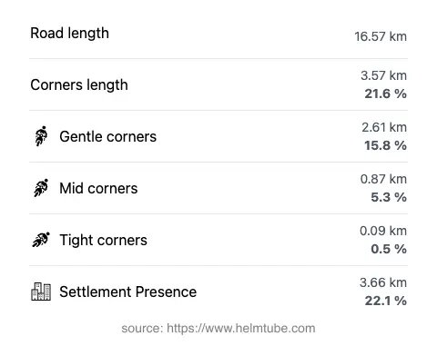
Županijska cesta 5033 is situated in the northwestern part of Croatia, within the Gorski Kotar area. The road primarily follows the course of the Kupa River, providing a riverside riding experience for most of its length. The route begins near the town of Delnice, a regional center known for its forested surroundings, and ends at the small village of Ribjek, close to the Slovenian border. The road passes through the settlement of Zrinska ulica and is characterized by its rural setting, with approximately one-fifth of the route traversing inhabited areas. An interactive map showing the precise alignment of Županijska cesta 5033 can be found at the end of this article.
Technical Details and Riding Experience
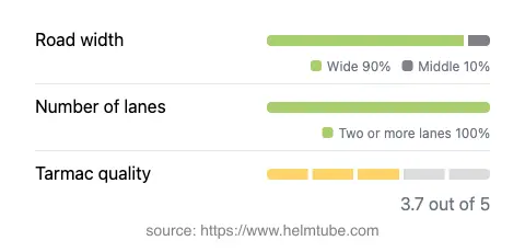
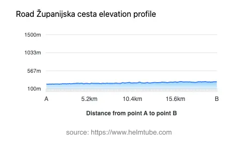
The total length of Županijska cesta 5033 is approximately 16.6 km (10.3 miles). The road surface is asphalt, with a quality rating that can be described as moderate to good. Riders can expect a generally smooth ride, though some sections may show signs of wear. The road is predominantly wide (about 89%), with a small portion being of medium width. Two lanes are present for the vast majority of the route (about 96%), allowing for comfortable passing and maneuvering. The elevation ranges from 221 m (725 ft) to 289 m (948 ft), indicating gentle undulations rather than steep climbs or descents. The road is not particularly twisty, offering gently curved sections that follow the river’s meanders, making it suitable for riders seeking a relaxed journey rather than a highly technical challenge.
Riverside Riding: The Kupa River
One of the defining features of Županijska cesta 5033 is its close proximity to the Kupa River, with about 90% of the route running alongside this waterway. The Kupa is a significant river in the region, eventually joining the Sava. The riverside setting provides a tranquil backdrop for the ride, with opportunities to observe the natural environment and, in some areas, access the riverbank. The road’s alignment along the river also means that it avoids major elevation changes, contributing to its gentle character. For those interested in the geography and significance of the Kupa, further information can be found on Wikipedia.
Road Access, Closures, and Fees
Županijska cesta 5033 is a public county road and is generally open to all vehicles, including motorcycles, throughout the year. There are no known seasonal closures specific to this road, and it is not subject to winter closure, though riders should be aware that weather conditions in Gorski Kotar can be variable, especially in colder months. No tolls or entrance fees are currently required to use this road. However, toll conditions in Croatia may change, and it is advisable to consult the official Croatian Motorways website for the latest information on road tolls and fees in the country. Event-related closures are rare, but local authorities may impose temporary restrictions for maintenance or public events; checking local sources before travel is recommended.
Nearby Attractions and Practical Information
While Županijska cesta 5033 itself is primarily a transit route, its proximity to Delnice offers access to the broader attractions of Gorski Kotar, such as the Risnjak National Park, known for its diverse flora and fauna. The town of Delnice provides basic amenities, fuel, and accommodation options for travelers. The village of Ribjek, at the road’s end, is a quiet settlement near the border with Slovenia, offering a peaceful conclusion to the ride. Riders are advised to ensure their motorcycles are in good condition, as services along the route itself are limited. For those interested in exploring further, the Kupa River is popular for fishing and kayaking, and the surrounding forests are suitable for hiking and wildlife observation.
Explore the Region: Roads Close By
Discover more amazing roads located near the route featured in this article. The list below highlights nearby routes that are perfect for extending your ride or planning your next adventure.
Ride the Best: Croatia’s Top Motorcycle Roads
These are the best motorbiking roads in Croatia. The list below shows links to articles about top-rated motorcycle routes in the country. Explore the most popular roads in Croatia and plan your next unforgettable motorbike adventure.