Crossing the Bischofseck Pass: Motorcycling from Bad Sankt Leonhard im Lavanttal to Wolfsberg
Locals know best!
If you travel this road often or live close by you will be given a chance to provide your valuable rating soon! Sign in and stay connected.Location and Overview of the Bischofseck Pass Road
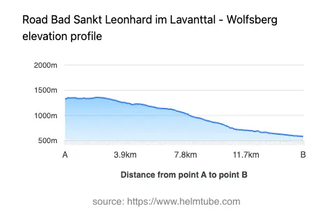
The Bischofseck Pass road connects the towns of Bad Sankt Leonhard im Lavanttal and Wolfsberg in the Austrian state of Carinthia. The route runs through the Saualpe and Lavanttaler Alpen, forming part of the broader Alps mountain system. The road's alignment takes riders from the spa town of Bad Sankt Leonhard im Lavanttal to the district capital Wolfsberg, passing through the settlement of Weißenbachstraße. This corridor is known for its alpine scenery and the technical challenge posed by the Bischofseck Pass, which reaches an elevation of 1,357 m (4,452 ft). An interactive map showing the road's route can be found at the end of the article.
Road Details and Riding Experience
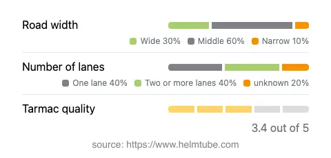
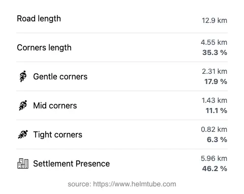
The Bischofseck Pass road extends for approximately 12.9 km (8 miles), with a surface composed of asphalt of moderate quality. Riders will encounter a mix of gently curved and moderately twisty sections, making it suitable for those seeking a balanced technical ride rather than extreme hairpins. The road features a combination of one-lane (about 42%) and two-lane (about 44%) segments, with the majority of the route offering a middle width (about 56%), and a significant portion being wide (30%). Narrow sections are limited (7%). The elevation ranges from 587 m (1,926 ft) at its lowest point to 1,359 m (4,459 ft) at its highest, with the Bischofseck Pass itself being the primary summit. The route passes through inhabited areas for nearly half its length (46.2%), providing occasional opportunities for rest or refueling in local settlements.
Mountain Pass and Surrounding Attractions
The highlight of this route is the crossing of the Bischofseck Pass, a lesser-known but significant mountain pass in the region. The road traverses the Saualpe, a mountain range characterized by its rolling alpine meadows and panoramic views. The broader Lavanttaler Alpen, through which the route also passes, are noted for their hiking trails and natural beauty. Riders may wish to explore the spa facilities in Bad Sankt Leonhard im Lavanttal or visit the historic center of Wolfsberg, which features a castle and several museums. The area is also part of the Gurk- und Lavanttaler Alpen as classified by SOIUSA, and forms a segment of the extensive Alps system, renowned for its diverse landscapes and outdoor activities.
Road Closures, Seasonal Access, and Toll Information
The Bischofseck Pass road is generally open to motorcycles throughout the year, but winter conditions can lead to temporary closures due to snow and ice, particularly at higher elevations. Riders are advised to check local traffic reports or the ASFINAG traffic reports for current status before planning a trip, especially in late autumn, winter, or early spring. There are no tolls or entrance fees specifically for this road at present, but toll conditions may change in the future. For up-to-date information on road tolls and fees in Austria, consult the ASFINAG toll vignette page.
Practical Tips for Motorcyclists
Given the road's moderate surface quality and variable width, riders should exercise caution, particularly in narrow or shaded sections where debris or moisture may be present. The mix of inhabited and remote stretches means that fuel and services are available but not ubiquitous; planning stops in Bad Sankt Leonhard im Lavanttal or Wolfsberg is recommended. Weather can change rapidly in the mountains, so appropriate gear and contingency plans are essential. The route's elevation profile and gentle curves make it accessible to a wide range of riders, from touring enthusiasts to those seeking a relaxed alpine ride. For those interested in exploring further, the surrounding Saualpe and Lavanttaler Alpen offer additional opportunities for day trips and exploration.
Explore the Region: Roads Close By
Discover more amazing roads located near the route featured in this article. The list below highlights nearby routes that are perfect for extending your ride or planning your next adventure.
Ride the Best: Austria’s Top Motorcycle Roads
These are the best motorbiking roads in Austria. The list below shows links to articles about top-rated motorcycle routes in the country. Explore the most popular roads in Austria and plan your next unforgettable motorbike adventure.