Motorcycling the Packsattel Pass: Wolfsberg to Köflach
Locals know best!
If you travel this road often or live close by you will be given a chance to provide your valuable rating soon! Sign in and stay connected.Location and Overview of the Packsattel Pass Route
The road connecting Wolfsberg and Köflach is situated in southern Austria, crossing the border between the states of Carinthia and Styria. The route follows the Packer Straße (B70), a primary regional road that ascends the Packsattel Pass, a notable crossing point in the Lavanttaler Alps. The starting point, Wolfsberg, is a town in the Lavant Valley, while Köflach lies to the north in the Voitsberg district. The road’s alignment takes it through a series of alpine valleys and over the Packsattel, providing access between these two regions. An interactive map showing the road’s course is available at the end of this article.

Road Characteristics and Riding Experience
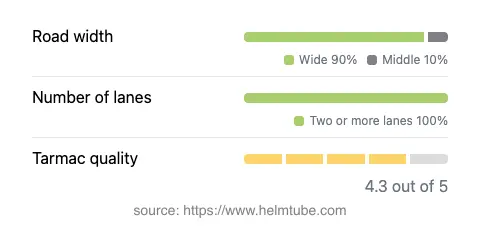
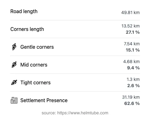
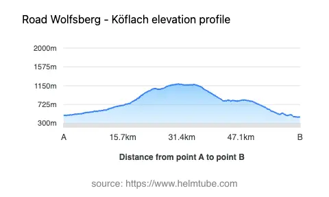
The Wolfsberg–Köflach route covers approximately 49.8 km (30.9 miles), with the majority of the road offering a wide, two-lane configuration (about 90%). The surface is asphalt and is generally rated as very good, providing a comfortable and predictable riding experience. The road is moderately curvy, with a mix of gently sweeping bends and occasional tighter turns, particularly on the ascent and descent of the Packsattel Pass. Elevation ranges from 441 m (1,447 ft) at its lowest point to 1,189 m (3,901 ft) at the summit, with the Packsattel itself reaching 1,169 m (3,835 ft). The route passes through several inhabited areas, accounting for roughly two-thirds of its length, which means riders should expect a mix of open country stretches and sections with local traffic. The road also runs adjacent to the Lavant and Teigitsch rivers for portions of its length, adding to the variety of the landscape.


Mountain Pass and Surrounding Geography
The central feature of this route is the Packsattel Pass, a historic crossing in the Lavanttal Alps. The pass is flanked by the Koralpe and Saualpe mountain ranges, with the road itself cutting through the heart of the Lavanttaler Alpen. The surrounding landscape is characterized by forested slopes, alpine meadows, and occasional panoramic views of the valleys below. The Packsattel has long served as a key connection between Carinthia and Styria, and its accessibility makes it a practical choice for motorcyclists. Notable nearby attractions include the spa town of Köflach and the historic center of Wolfsberg. The route also skirts the edge of the Koralpe range, known for its hiking and winter sports opportunities.
Traffic, Speed Limits, and Seasonal Considerations
The Packer Straße is a public road with variable speed limits, typically ranging from 50 km/h (31 mph) in inhabited areas to 70–100 km/h (43–62 mph) in open stretches. Riders should be attentive to posted limits, as they can change frequently along the route. The road is generally open year-round, but winter conditions can lead to temporary closures or restrictions, especially at higher elevations near the Packsattel. Snow and ice are common from late autumn through early spring, and local authorities may impose chain requirements or close the pass during severe weather. It is advisable to check current road conditions before planning a ride, particularly outside the summer months. Information on road closures and traffic updates can be found on the ASFINAG Traffic Information website.
Tolls, Fees, and Practical Information
There is currently no toll or entrance fee required for motorcycles or other vehicles to use the Packsattel Pass route between Wolfsberg and Köflach. However, toll conditions may change in the future, and riders are encouraged to verify the latest information before departure. For comprehensive details on tolls and road fees in Austria, including updates on any changes, visit the ASFINAG Toll Information page. Fuel stations and basic services are available in both Wolfsberg and Köflach, as well as in some of the smaller settlements along the route. The road is popular with local traffic, especially during weekends and holidays, so increased caution is recommended during peak periods.
Explore the Region: Roads Close By
Discover more amazing roads located near the route featured in this article. The list below highlights nearby routes that are perfect for extending your ride or planning your next adventure.
Ride the Best: Austria’s Top Motorcycle Roads
These are the best motorbiking roads in Austria. The list below shows links to articles about top-rated motorcycle routes in the country. Explore the most popular roads in Austria and plan your next unforgettable motorbike adventure.