Motorcycling the Klippitztörl Pass: Althofen to Bad Sankt Leonhard im Lavanttal
Locals know best!
If you travel this road often or live close by you will be given a chance to provide your valuable rating soon! Sign in and stay connected.Location and Route Overview
The Klippitztörl Pass road is situated in southern Austria, traversing the Lavanttaler Alps between the towns of Althofen and Bad Sankt Leonhard im Lavanttal. The route primarily follows the Klippitztörlstraße, passing through the small settlement of Graben. Riders will find themselves skirting the Saualpe mountain range and crossing the Lavanttaler Alpen, with the road reaching its highest point at the Klippitztörl mountain pass. The region is characterized by its alpine landscapes and proximity to valleys such as the Görtschitztal. An interactive map showing the full route is available at the end of this article.
Road Characteristics and Riding Experience
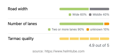
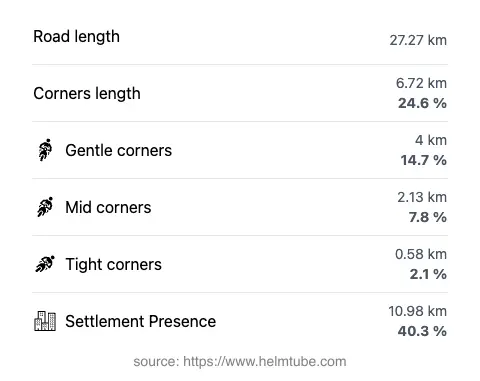
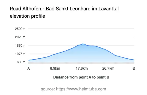
The Klippitztörl Pass road extends for approximately 27.3 km (17 miles), with the majority of the route featuring wide, two-lane sections (about 90%). The asphalt surface is of excellent quality, providing a smooth and reliable grip for motorcycles. The road is moderately curvy, offering a mix of gently winding stretches and occasional tighter bends, making it suitable for riders of varying skill levels. Elevation ranges from 711 m (2,333 ft) at its lowest point to 1,643 m (5,390 ft) at the summit, with the Klippitztörl pass itself reaching 1,644 m (5,394 ft). The maximum speed limit along the route is 70 km/h (43 mph), which is typical for mountain roads in Austria. Approximately 40% of the road passes through inhabited areas, while the remainder offers open alpine riding. The route is also notable for its viewpoints, providing opportunities to pause and take in the surrounding mountain scenery.
Seasonal Accessibility and Road Closures
The Klippitztörl Pass is generally open to motorcyclists throughout the year, but winter conditions can lead to temporary closures due to snow and ice, particularly at higher elevations. Riders should be aware that closures may occur from late autumn through early spring, depending on weather conditions. There are no permanent restrictions for motorcycles, but it is advisable to check local traffic updates or the ASFINAG traffic information service before planning a ride, especially outside the summer months. Event-related closures are rare but may occur during local cycling or motorsport events.
Tolls, Fees, and Regulations
Currently, there is no dedicated toll or entrance fee for motorcycles using the Klippitztörl Pass road. However, Austria requires a motorway vignette for vehicles using its autobahns and expressways, but this does not apply to the Klippitztörlstraße. Riders should remain informed about potential changes to toll regulations, as conditions may change in the future. For the most up-to-date information on road tolls and vignettes in Austria, consult the official ASFINAG toll vignette page.
Points of Interest and Surrounding Attractions
Along the Klippitztörl Pass, riders can enjoy several viewpoints offering expansive vistas of the Lavanttaler Alps and the Saualpe range. The nearby town of Althofen is known for its medieval old town and the Heinrich Harrer Museum, dedicated to the famous Austrian mountaineer and explorer. At the other end, Bad Sankt Leonhard im Lavanttal is recognized for its thermal spas and historic architecture. The road itself is a gateway to exploring the broader Lavanttal Alps, a region popular among hikers and outdoor enthusiasts. For those interested in the natural environment, the Saualpe mountain range offers additional hiking trails and panoramic views. These attractions make the Klippitztörl Pass not only a rewarding ride but also a starting point for further exploration in Carinthia.
Explore the Region: Roads Close By
Discover more amazing roads located near the route featured in this article. The list below highlights nearby routes that are perfect for extending your ride or planning your next adventure.
Ride the Best: Austria’s Top Motorcycle Roads
These are the best motorbiking roads in Austria. The list below shows links to articles about top-rated motorcycle routes in the country. Explore the most popular roads in Austria and plan your next unforgettable motorbike adventure.