Exploring the Bodrež–Lokovec Road: A Technical Ride Through Slovenia’s Hills
Locals know best!
If you travel this road often or live close by you will be given a chance to provide your valuable rating soon! Sign in and stay connected.Location and Route Overview
The Bodrež–Lokovec road is situated in the western part of Slovenia, traversing the hills above the Soča Valley. The route connects the settlements of Bodrež, Kal nad Kanalom, Avče, Levpa, and Lokovec, forming a link between the lower valley and the elevated plateaus. The road’s proximity to the Soča River (Isonzo) adds to its geographical interest, though only a small portion of the route runs directly alongside the river. An interactive map showing the precise route can be found at the end of this article.
Road Characteristics and Riding Experience
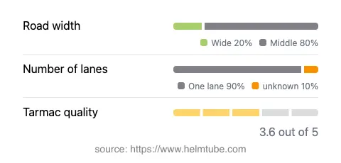
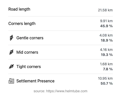
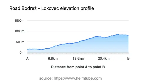
This road stretches for approximately 21.6 km (13.4 miles), with elevations ranging from 129 m (423 ft) to 850 m (2,789 ft). The surface is asphalt of moderate quality, generally rated as fair to good. Riders will encounter a moderately twisty alignment, with a mix of gentle and sharper bends, making it suitable for those seeking a technical but not overly demanding ride. The road is predominantly narrow, with about 95% consisting of a single lane and only a small portion offering two lanes. Width varies, with the majority (about 72%) being of medium width, while some sections are notably narrow or wide. The maximum speed limit is 30 km/h (19 mph), reflecting the road’s winding nature and the presence of inhabited areas along roughly half its length. The route passes through a combination of rural settlements and forested stretches, offering a varied riding environment.
Points of Interest Along the Route
While the Bodrež–Lokovec road itself is not widely recognized as a tourist destination, it provides access to several small villages that retain traditional Slovenian rural character. The nearby Soča River is a major attraction in the region, known for its emerald waters and outdoor activities such as kayaking and fishing. The settlements of Kal nad Kanalom and Lokovec are typical of the area, featuring stone houses and panoramic views of the surrounding hills. For those interested in local culture, the region is also known for its historical ties to World War I, with the Soča Valley being the site of significant battles. More information about the area can be found on Wikivoyage.
Road Closures, Tolls, and Practical Information
There are currently no known seasonal or event-related closures affecting the Bodrež–Lokovec road for motorcycles. The road remains open throughout the year, though weather conditions in winter may impact accessibility due to snow or ice, especially at higher elevations. There are no tolls or entrance fees required to use this road. Riders should be aware that toll conditions may change in the future; for the most up-to-date information on road tolls and fees in Slovenia, consult the official DARS website.
Planning Your Ride and Map Access
Given the road’s moderate surface quality and narrow profile, it is best suited for experienced riders comfortable with variable conditions and lower speeds. The route offers a quiet alternative to busier valley roads, with opportunities to explore authentic Slovenian countryside. For those planning a trip, it is advisable to check local weather forecasts and road conditions, particularly in winter months. An interactive map of the Bodrež–Lokovec road is available below to assist with navigation and trip planning.
Explore the Region: Roads Close By
Discover more amazing roads located near the route featured in this article. The list below highlights nearby routes that are perfect for extending your ride or planning your next adventure.
Ride the Best: Slovenia’s Top Motorcycle Roads
These are the best motorbiking roads in Slovenia. The list below shows links to articles about top-rated motorcycle routes in the country. Explore the most popular roads in Slovenia and plan your next unforgettable motorbike adventure.