Exploring the Bregenzerwaldstraße and Hochtannberg Pass: A Motorcyclist’s Guide
Locals know best!
If you travel this road often or live close by you will be given a chance to provide your valuable rating soon! Sign in and stay connected.Location and Overview of the Bregenzerwaldstraße
The Bregenzerwaldstraße, also known among motorcyclists as the route over the Hochtannberg Pass, is situated in the western Austrian state of Vorarlberg. The road connects the Bregenzerwald region with the village of Warth, passing through the Holzboden-Galerie and Holzboden-Tunnel. The route lies within the Allgäu Alps and crosses the Lechquellengebirge and Bregenz Forest Mountains, offering a diverse alpine landscape. The road closely follows the Bregenzer Ach river for a significant portion of its length and traverses the Tal der Bregenzer Ach valley. The area is characterized by its alpine scenery, traditional villages, and proximity to the German border. An interactive map showing the road can be found at the end of the article.
Road Characteristics and Riding Experience
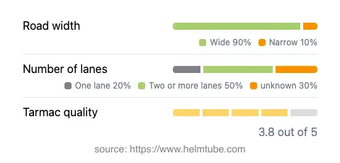
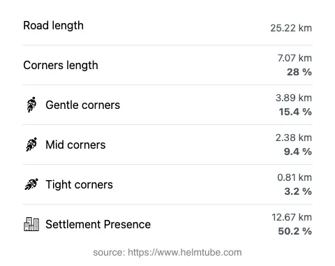
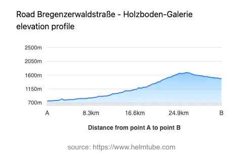
The Bregenzerwaldstraße stretches for approximately 25.2 km (15.7 miles), with elevations ranging from 758 m (2,487 ft) to 1,685 m (5,528 ft). The road surface is asphalt, generally rated as good, though some sections may show moderate wear. Riders will encounter a mix of gently curved and moderately twisty segments, making it suitable for both experienced and intermediate motorcyclists. The route features predominantly wide lanes (about 90%), with some narrower sections, particularly near the Holzboden-Galerie and the approach to the Hochtannberg Pass. The road passes through inhabited areas for roughly half its length, providing opportunities for rest stops and refreshments. The maximum speed limits vary along the route, typically ranging from 40 km/h (25 mph) to 100 km/h (62 mph), depending on the section and proximity to settlements or sharp bends.
Mountain Passes, Valleys, and Natural Features
A highlight of this route is the crossing of the Hochtannberg Pass, which reaches an elevation of 1,676 m (5,499 ft). This pass is a well-known destination for motorcyclists due to its alpine vistas and the technical riding required on its approach. The road also skirts the Bregenz Forest Mountains and traverses the Lechquellengebirge. The Bregenzer Ach river accompanies the road for over half its length, providing a dynamic backdrop of flowing water and lush valley scenery. The Tal der Bregenzer Ach valley is another prominent feature, offering expansive views and a sense of openness uncommon in more confined alpine passes. Several viewpoints along the route allow riders to pause and appreciate the surrounding landscape.
Road Closures, Seasonal Access, and Regulations
The Bregenzerwaldstraße and Hochtannberg Pass are generally open to motorcycles throughout the year, but winter conditions can lead to temporary closures due to snow and ice, particularly at higher elevations. It is advisable to check local traffic updates before planning a ride, especially in late autumn, winter, and early spring. There are no known permanent restrictions for motorcycles on this route. Event-related closures are rare but may occur during local festivals or road maintenance. For up-to-date information on road conditions and closures, consult the ASFINAG Traffic Reports.
Tolls, Fees, and Additional Information
Currently, there are no tolls or entrance fees specifically for motorcycles on the Bregenzerwaldstraße or the Hochtannberg Pass. However, toll conditions may change in the future, and riders should verify the latest information before departure. For comprehensive details on tolls and fees for Austrian roads, including updates and regulations, visit the ASFINAG Toll Information page. The road is well-maintained, but weather conditions can affect surface quality, especially after winter. Riders are encouraged to equip their motorcycles appropriately for alpine conditions and to observe all posted speed limits and local traffic laws.
Explore the Region: Roads Close By
Discover more amazing roads located near the route featured in this article. The list below highlights nearby routes that are perfect for extending your ride or planning your next adventure.
Ride the Best: Austria’s Top Motorcycle Roads
These are the best motorbiking roads in Austria. The list below shows links to articles about top-rated motorcycle routes in the country. Explore the most popular roads in Austria and plan your next unforgettable motorbike adventure.