Staller Saddle (Staller Sattel / Passo di Stalle): A Technical Overview for Motorcyclists
Locals know best!
If you travel this road often or live close by you will be given a chance to provide your valuable rating soon! Sign in and stay connected.Location and Geographic Context
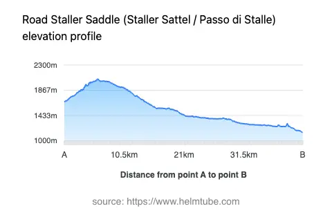
The Staller Saddle (Staller Sattel / Passo di Stalle) is situated in Austria, forming a connection between the Defereggental valley and the Antholzertal in Italy. The road traverses the main Alpine ridge, reaching a maximum elevation of 2,058 m (6,752 ft) at the pass itself. The route is embedded within the Alps, specifically intersecting several subranges such as the Lasörling-Gruppe, Lasörlingkamm, Winkeltaler Berge, Weiße Spitze-Hochgrobe-Kette, and Panargenkamm. The nearest major settlement to the Austrian side is Matrei in Osttirol, located approximately 9.6 km (6 miles) from the starting point. An interactive map showing the road can be found at the end of the article.
Road Characteristics and Riding Experience
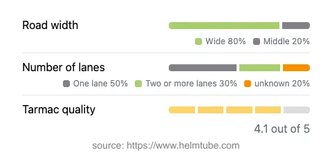
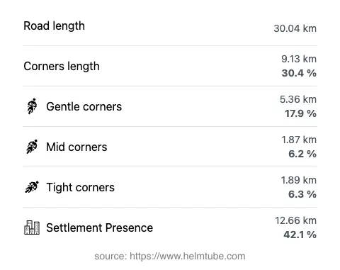
The Staller Saddle road is primarily surfaced with asphalt of good quality, providing a generally smooth ride. The route extends for approximately 30 km (18.6 miles), with the majority (about 80%) being wide enough for comfortable passage, while a smaller proportion is of medium or narrow width. The road configuration varies, with roughly half consisting of a single lane and just over a quarter offering two lanes. Riders will encounter a moderately twisty alignment, making it suitable for those who appreciate technical riding without excessive hairpins. The elevation ranges from 1,146 m (3,760 ft) at its lowest point to 2,058 m (6,752 ft) at the summit. The maximum speed limit is 70 km/h (43 mph), though actual speeds may be lower due to road width and traffic conditions. The route passes through several settlements and notable waypoints, including Defereggental-Landesstraße, Staller-Sattel-Straße - Via Passo Stalle, Mellitztunnel, Mellitzgalerie, and Moosbachgalerie. The road also runs adjacent to the Defereggental valley for a significant portion of its length. For further reading on the pass, see Staller Saddle (Wikipedia).
Seasonal Accessibility and Closures
The Staller Saddle is subject to seasonal closures due to its high elevation and alpine weather conditions. The road is typically closed to all traffic, including motorcycles, during the winter months, generally from late October to late May, depending on snow conditions. Temporary closures may also occur due to adverse weather or maintenance work. Riders are advised to check current road status before planning a trip. Up-to-date information on closures can be found on the official Tirol Road Closures website.
Tolls, Fees, and Regulations
Currently, there is no toll or entrance fee for motorcycles using the Staller Saddle on the Austrian side. However, toll conditions may change in the future, and riders should verify the latest information before travel. For comprehensive details on road tolls and entrance fees in Austria, consult the ASFINAG Vignette Information page. Note that regulations regarding vehicle size and traffic flow may apply, especially on the single-lane sections, where alternating one-way traffic is controlled by traffic lights.
Points of Interest and Surrounding Attractions
The Staller Saddle offers access to several viewpoints and natural attractions along its route. The Defereggental valley, which the road follows for a significant stretch, is known for its alpine landscapes and traditional Tyrolean villages. The pass itself provides panoramic views of the surrounding Alps, making it a popular stop for motorcyclists and tourists alike. Riders may also wish to explore the nearby town of Matrei in Osttirol, which serves as a gateway to the Hohe Tauern National Park. For those interested in the broader Alpine context, the road's crossing of the main Alpine ridge is a notable feature, connecting diverse cultural and natural regions. Additional information about the Alps can be found on Wikipedia.
Explore the Region: Roads Close By
Discover more amazing roads located near the route featured in this article. The list below highlights nearby routes that are perfect for extending your ride or planning your next adventure.
Ride the Best: Austria’s Top Motorcycle Roads
These are the best motorbiking roads in Austria. The list below shows links to articles about top-rated motorcycle routes in the country. Explore the most popular roads in Austria and plan your next unforgettable motorbike adventure.