Exploring the Ebniter Tal Road: Hohenems to Dornbirn by Motorcycle
Locals know best!
If you travel this road often or live close by you will be given a chance to provide your valuable rating soon! Sign in and stay connected.Location and Geographic Context
The Ebniter Tal Road is situated in western Austria, within the federal state of Vorarlberg. It connects the towns of Hohenems and Dornbirn, traversing the Ebniter Valley (Ebniter Tal) and running alongside the Dornbirner Ache river for a significant portion of its length. The road passes through the Bregenz Forest Mountains (Bregenz Forest Mountains), a subrange of the Alps, and provides access to the small settlement of Ebnit. This region is characterized by its alpine terrain, forested slopes, and proximity to Lake Constance (Bodensee). An interactive map showing the route can be found at the end of the article.
Road Characteristics and Riding Experience
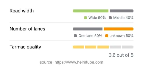
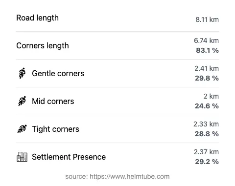
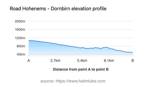
The Ebniter Tal Road covers a distance of approximately 8.1 km (5 miles), with elevations ranging from 499 m (1,637 ft) at its lowest point to 1,075 m (3,527 ft) at its highest. The road is predominantly asphalt, with a surface quality that can be described as fair to good, though some sections may require attentive riding due to moderate wear. The route is notably curvy, offering a series of bends and turns that demand focus but do not reach the extreme technicality of some alpine passes. About half of the road consists of a single lane, while the remainder alternates between medium and wide sections, with wide stretches making up the majority (about 64%). The road runs through inhabited areas for roughly 29% of its length, with the remainder passing through forested and mountainous terrain. Speed limits vary along the route, typically set at 30, 40, or 50 km/h (19, 25, or 31 mph), reflecting the road's winding nature and the presence of narrow segments.
Natural Features and Attractions
One of the defining features of the Ebniter Tal Road is its close proximity to the Dornbirner Ache, a river that accompanies the road for much of its length before flowing into Lake Constance and the Rhine. The route also traverses the Ebniter Valley, a lesser-known but picturesque alpine valley. Riders will encounter several viewpoints along the way, offering opportunities to pause and appreciate the surrounding mountain scenery. The road's passage through the Bregenz Forest Mountains provides access to hiking trails and natural observation points, making it a suitable choice for those interested in combining motorcycling with outdoor activities. The nearby town of Dornbirn is known for attractions such as the Rappenloch Gorge, a notable geological site, while Hohenems offers cultural sites including the Palace Hohenems.
Seasonal Accessibility and Road Closures
The Ebniter Tal Road is subject to seasonal closures, particularly during winter months when snow and ice can render the route impassable. Temporary closures may also occur due to maintenance work or adverse weather conditions, especially in the higher sections of the road. Motorcyclists are advised to check local traffic updates or the ASFINAG traffic reports before planning a ride, as conditions can change rapidly in alpine environments. There are no permanent restrictions on motorcycle access, but caution is recommended during periods of heavy rainfall or after storms, as debris and water runoff can affect road safety.
Tolls, Fees, and Practical Information
Currently, there are no tolls or entrance fees required to use the Ebniter Tal Road. However, toll conditions in Austria may change, and it is advisable to consult official sources for the most up-to-date information. For comprehensive details on road tolls and vignettes in Austria, riders can refer to the ASFINAG vignette information page. Parking at viewpoints or trailheads along the route may be subject to local regulations, so checking signage on-site is recommended.
Explore the Region: Roads Close By
Discover more amazing roads located near the route featured in this article. The list below highlights nearby routes that are perfect for extending your ride or planning your next adventure.
Ride the Best: Austria’s Top Motorcycle Roads
These are the best motorbiking roads in Austria. The list below shows links to articles about top-rated motorcycle routes in the country. Explore the most popular roads in Austria and plan your next unforgettable motorbike adventure.