Exploring the Finstermünz Pass Road: Reschenstraße to Kajetansbrücke
Locals know best!
If you travel this road often or live close by you will be given a chance to provide your valuable rating soon! Sign in and stay connected.Location and Overview of the Finstermünz Pass Road
The Finstermünz Pass Road, connecting Reschenstraße and Kajetansbrücke, is situated in western Austria, within the Tyrolean Alps. The route runs close to the border with Switzerland and Italy, making it a strategic passage for travelers moving between these countries. The nearest notable settlement to the route's endpoint is the village of Nauders. The road follows the upper Inn Valley (Oberes Gericht), a region known for its alpine landscapes and historical significance. An interactive map showing the precise route of the Finstermünz Pass Road can be found at the end of this article.
Road Characteristics and Riding Experience
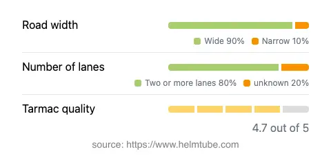
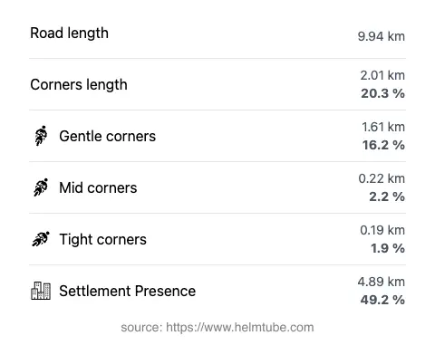
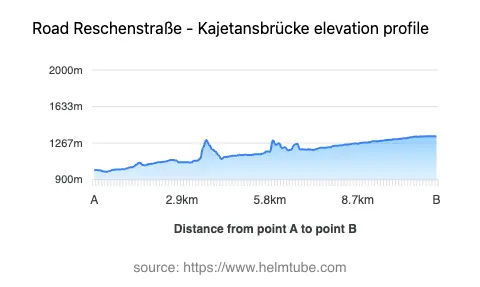
The Finstermünz Pass Road covers a distance of approximately 9.9 km (6.2 miles), with elevations ranging from 978 m (3,209 ft) to 1,337 m (4,386 ft). The road surface is asphalt and is generally of high quality, offering a smooth ride for most of its length. The route is predominantly wide (about 90%), with two lanes for the majority of the distance, ensuring comfortable passage for both motorcycles and other vehicles. The road is moderately curvy, providing a mix of gently curved and more technical sections, but it is not considered extremely twisty. Nearly half of the route passes through inhabited areas, while the remainder traverses open alpine terrain. The maximum speed limits vary along the route, with posted limits of 100 km/h (62 mph), 80 km/h (50 mph), 60 km/h (37 mph), and 50 km/h (31 mph) depending on the specific section and proximity to settlements.
Natural Features and Attractions Along the Route
This road is notable for its passage through the Alps and its proximity to the Inn River, which it follows for a significant portion (42%). The route also traverses the Oberes Gericht valley, an area with a rich cultural and historical background. Motorcyclists will find several viewpoints along the way, offering opportunities to pause and appreciate the surrounding alpine scenery. The Finstermünz Pass itself is a historical mountain crossing, and its location at 1,186 m (3,891 ft) provides expansive views of the surrounding peaks and valleys. The combination of river, valley, and mountain landscapes makes this road a compelling choice for riders seeking both technical riding and natural beauty.
Road Closures, Seasonal Access, and Practical Considerations
The Finstermünz Pass Road is generally open to motorcycles throughout the year, but weather conditions in the Alps can lead to temporary closures, especially during winter months due to snow or ice. Riders are advised to check local traffic reports and weather forecasts before planning a trip, as alpine routes can be affected by sudden weather changes or maintenance work. There are no permanent restrictions on motorcycle access for this route. For up-to-date information on road conditions and closures in Austria, the ASFINAG Traffic Reports website provides current updates.
Tolls, Fees, and Additional Information
Currently, there is no specific toll or entrance fee required for motorcycles to use the Finstermünz Pass Road between Reschenstraße and Kajetansbrücke. However, toll conditions in Austria may change, and riders should verify the latest requirements before traveling. For comprehensive information on road tolls and vignette requirements in Austria, consult the ASFINAG Toll and Vignette page. It is important to note that while this particular section does not require a toll, other nearby alpine routes may have different regulations.
Explore the Region: Roads Close By
Discover more amazing roads located near the route featured in this article. The list below highlights nearby routes that are perfect for extending your ride or planning your next adventure.
Ride the Best: Austria’s Top Motorcycle Roads
These are the best motorbiking roads in Austria. The list below shows links to articles about top-rated motorcycle routes in the country. Explore the most popular roads in Austria and plan your next unforgettable motorbike adventure.