Riding the Norbertshöhe Pass: Martinsbrucker Straße for Motorcyclists
Locals know best!
If you travel this road often or live close by you will be given a chance to provide your valuable rating soon! Sign in and stay connected.Location and Route Overview
Martinsbrucker Straße is situated in the western part of Austria, within the Tyrolean Alps. The road serves as a connector between the village of Nauders in Austria and Martina in Switzerland, crossing the Norbertshöhe Pass. The route is positioned at the intersection of the Engiadina Bassa and Oberes Gericht valleys, providing access to both regions. The road is part of the broader Alpine mountain range, making it a strategic passage for those traveling between Austria and Switzerland. An interactive map showing the precise route of Martinsbrucker Straße can be found at the end of this article.
Road Characteristics and Riding Experience
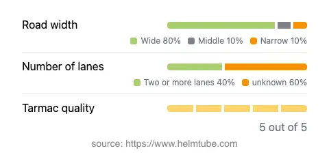
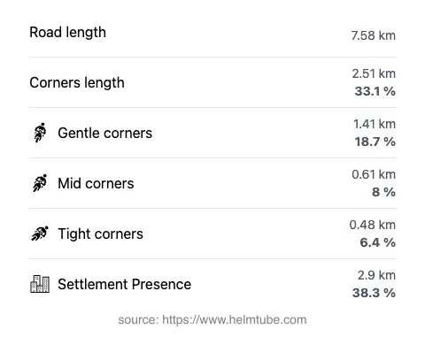
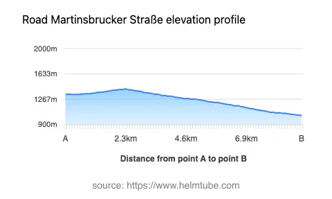
The Martinsbrucker Straße extends for approximately 7.6 km (4.7 miles), with elevations ranging from 1,035 m (3,396 ft) at its lowest point to 1,415 m (4,642 ft) at its highest. The road is predominantly wide (about 81%), with the remainder being of middle or narrow width. It features two lanes for a significant portion (about 40%), allowing for comfortable passage in both directions. The surface is asphalt and is rated as excellent, providing a reliable grip and smooth ride for motorcycles. The road is moderately curvy, offering a mix of gentle and sharper bends, but does not reach the extreme twistiness found in some other Alpine passes. Speed limits vary along the route, with posted limits of 30, 50, 60, and 100 km/h (19, 31, 37, and 62 mph) depending on the section and proximity to inhabited areas. Approximately 38% of the road passes through or near settlements, requiring attention to local traffic and speed regulations.
Norbertshöhe Pass and Surrounding Attractions
The highlight of Martinsbrucker Straße is its crossing of the Norbertshöhe Pass, a mountain pass at 1,405 m (4,610 ft) that serves as a gateway between Austria and Switzerland. The pass is known for its panoramic viewpoints, offering expansive views of the surrounding Alps and valleys. The road runs adjacent to the Engiadina Bassa (Lower Engadine) valley and the Oberes Gericht valley, both of which are recognized for their natural beauty and cultural significance. Riders can also enjoy the proximity to the broader Alps mountain range, which dominates the landscape and provides a dramatic backdrop throughout the journey. Viewpoints along the route allow for brief stops to appreciate the alpine scenery and take photographs.
Road Closures, Seasonal Access, and Regulations
Martinsbrucker Straße, including the Norbertshöhe Pass, is generally open to motorcyclists throughout the year. However, due to its elevation and alpine location, the road may be subject to temporary closures during winter months or adverse weather conditions, particularly due to snow or ice. Riders are advised to check local traffic reports and weather forecasts before planning a trip, especially outside the summer season. There are no known event-related closures affecting this route on a regular basis. For up-to-date information on road conditions and potential closures, the ASFINAG Traffic Reports website provides current updates for Austrian roads.
Tolls, Fees, and Practical Information
Currently, there is no dedicated toll or entrance fee for motorcycles using Martinsbrucker Straße or the Norbertshöhe Pass. However, toll conditions in Austria may change, and riders should verify the latest requirements before travel. For general information on road tolls and vignettes in Austria, including updates on any changes, consult the ASFINAG Toll and Vignette page. It is important to note that while this specific road does not require a toll, other nearby routes or highways may have separate toll requirements.
Explore the Region: Roads Close By
Discover more amazing roads located near the route featured in this article. The list below highlights nearby routes that are perfect for extending your ride or planning your next adventure.
Ride the Best: Austria’s Top Motorcycle Roads
These are the best motorbiking roads in Austria. The list below shows links to articles about top-rated motorcycle routes in the country. Explore the most popular roads in Austria and plan your next unforgettable motorbike adventure.