Exploring the Gföhler Straße: A Technical Overview for Motorcyclists
Locals know best!
If you travel this road often or live close by you will be given a chance to provide your valuable rating soon! Sign in and stay connected.Location and Geographic Context
The Gföhler Straße is situated in the northeastern part of Austria, within the state of Lower Austria. The road connects the village of Neupölla to the town of Gföhl, traversing a region characterized by gentle hills and agricultural landscapes. The route runs partially alongside the Kamp River, a notable waterway in the area, which eventually flows into the Große Krems. The proximity to the Kamp River adds a natural element to the journey, with occasional viewpoints offering glimpses of the river valley. An interactive map showing the precise route of the Gföhler Straße can be found at the end of this article.
Road Characteristics and Riding Experience
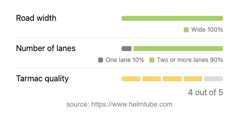
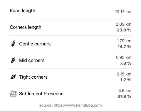
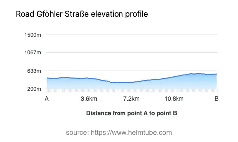
The Gföhler Straße extends for approximately 12.2 km (7.6 miles), providing a direct connection between Neupölla and Gföhl. The road surface is asphalt and is generally rated as very good, with only minor imperfections. The route is not particularly twisty, featuring mostly gentle curves that allow for a relaxed riding experience. The majority of the road is wide (about 95%), with two lanes dominating the layout (about 87%), ensuring comfortable passage for both motorcycles and other vehicles. Only a small portion is narrow or single-lane, which is unlikely to pose significant challenges. The elevation ranges from 349 m (1,145 ft) at its lowest point to 566 m (1,857 ft) at its highest, resulting in mild elevation changes suitable for riders of all skill levels. The maximum speed limit is 50 km/h (31 mph), reflecting the road's passage through inhabited areas and its role as a regional connector.
Natural Features and Attractions Along the Route
One of the defining features of the Gföhler Straße is its adjacency to the Kamp River for approximately 19% of its length. This proximity provides occasional opportunities to enjoy river views, particularly at designated viewpoints along the route. While the road itself does not pass directly through major tourist destinations, the viewpoints offer riders a chance to pause and appreciate the surrounding landscape. The region is known for its tranquil rural scenery, making it a pleasant backdrop for a motorcycle journey. The town of Gföhl, at the eastern terminus, serves as a local hub and offers basic amenities for travelers.
Road Closures, Seasonal Considerations, and Regulations
There are currently no known restrictions or closures specific to motorcycles on the Gföhler Straße. The road remains open throughout the year, with no regular seasonal closures reported. However, as with many roads in Lower Austria, winter conditions may occasionally impact accessibility due to snow or ice, particularly in higher elevation sections. Riders are advised to check local traffic updates before planning a trip during the colder months. No event-related closures have been documented for this route.
Tolls, Fees, and Additional Information
The Gföhler Straße does not currently require the payment of a toll or entrance fee for motorcycles or other vehicles. Riders should be aware that toll conditions may change in the future, and it is advisable to consult official resources for the most up-to-date information. For comprehensive details on road tolls and vignette requirements in Austria, refer to the ASFINAG Vignette Information website.
Explore the Region: Roads Close By
Discover more amazing roads located near the route featured in this article. The list below highlights nearby routes that are perfect for extending your ride or planning your next adventure.
Ride the Best: Austria’s Top Motorcycle Roads
These are the best motorbiking roads in Austria. The list below shows links to articles about top-rated motorcycle routes in the country. Explore the most popular roads in Austria and plan your next unforgettable motorbike adventure.