Exploring the Gars am Kamp – Wegscheid am Kamp Road: A Motorcyclist’s Guide
Locals know best!
If you travel this road often or live close by you will be given a chance to provide your valuable rating soon! Sign in and stay connected.Location and Overview
The Gars am Kamp – Wegscheid am Kamp road is situated in Lower Austria, traversing the picturesque Kamp Valley. The route begins near the town of Gars am Kamp and concludes at the village of Wegscheid am Kamp, passing through settlements such as St. Leonhardstraße, Gföhlerstraße, Dreifaltigkeitsplatz, and Gföhler Straße. The road follows the Kamp River for a portion of its length, offering views of the surrounding countryside and occasional glimpses of the waterway. This corridor is characterized by a mix of inhabited and rural areas, providing a varied riding experience. An interactive map showing the road can be found at the end of the article.
Road Characteristics and Riding Experience
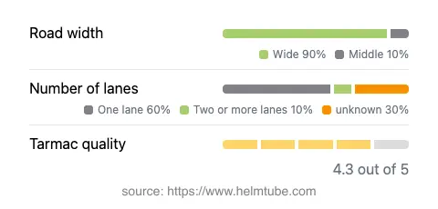
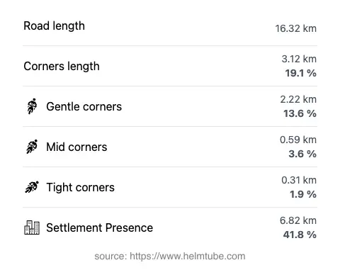
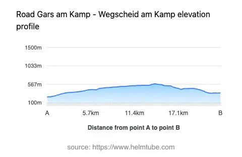
The Gars am Kamp – Wegscheid am Kamp route extends for approximately 16.3 km (10.1 miles), with an elevation range from 248 m (814 ft) to 580 m (1,903 ft). The road surface is asphalt and is generally rated as very good, offering a smooth ride for most motorcycles. The route is moderately curvy, with gentle bends that allow for a relaxed pace rather than aggressive cornering. Most of the road is wide (about 86%), with some sections narrowing, particularly near settlements. The majority of the route consists of one lane, with a small portion offering two lanes. Riders should be aware that around 41.8% of the road passes through inhabited areas, which may require additional caution due to local traffic and pedestrians. The maximum speed limit is 50 km/h (31 mph), reflecting the mixed-use nature of the road and its proximity to residential zones.
Natural Features and Attractions
The road runs adjacent to the Kamp River for approximately 11% of its length, providing occasional riverside views. The Kamp Valley is known for its gentle hills and lush landscapes, making it a pleasant backdrop for a motorcycle journey. Along the route, riders will encounter at least one notable viewpoint, offering an opportunity to pause and appreciate the surrounding scenery. The proximity to the river and the presence of viewpoints make this road appealing for those interested in combining riding with brief stops for photography or relaxation.
Road Closures, Seasonal Considerations, and Tolls
There are no known restrictions or closures specific to motorcycles on the Gars am Kamp – Wegscheid am Kamp road. The route is not subject to regular winter closures, as it does not traverse high mountain passes or areas prone to heavy snowfall. However, riders should always check local traffic updates for any temporary closures due to roadworks or events. There is currently no toll or entrance fee required to use this road. Toll conditions in Austria may change in the future, and riders are advised to consult the ASFINAG website for the most up-to-date information on road tolls and vignettes in Austria.
Practical Tips for Motorcyclists
Given the road’s moderate length and gentle curves, it is suitable for riders of all experience levels. The high quality of the asphalt surface ensures a comfortable ride, though caution is advised in inhabited areas where local traffic and pedestrians are more common. The route’s proximity to the Kamp River and the presence of viewpoints make it ideal for a leisurely ride with stops to enjoy the landscape. Facilities such as fuel stations and cafes can be found in Gars am Kamp, the largest settlement along the route. For those interested in exploring further, the Kamp Valley offers additional attractions and opportunities for extended touring. An interactive map of the route is available at the end of this article for trip planning purposes.
Explore the Region: Roads Close By
Discover more amazing roads located near the route featured in this article. The list below highlights nearby routes that are perfect for extending your ride or planning your next adventure.
Ride the Best: Austria’s Top Motorcycle Roads
These are the best motorbiking roads in Austria. The list below shows links to articles about top-rated motorcycle routes in the country. Explore the most popular roads in Austria and plan your next unforgettable motorbike adventure.