Exploring the Gleinalpe Crossing: Gratwein-Straßengel to Bärnbach by Motorcycle
Locals know best!
If you travel this road often or live close by you will be given a chance to provide your valuable rating soon! Sign in and stay connected.Location and Overview of the Route
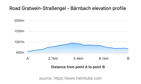
The road between Gratwein-Straßengel and Bärnbach is situated in the Austrian state of Styria, crossing the Gleinalpe mountain range. The route begins near the town of Gratwein-Straßengel and concludes at Bärnbach, both of which are accessible settlements in the region. The road passes through the locality of Pleschstraße and is characterized by its alpine setting, with elevations ranging from 651 m (2,136 ft) to 1,014 m (3,327 ft). This corridor serves as a connector between the Graz basin and the western Styrian valleys, offering access to the less-traveled interior of the Gleinalpe. An interactive map showing the road can be found at the end of the article.
Road Characteristics and Riding Experience
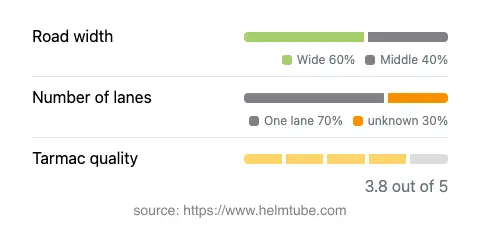
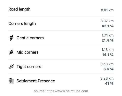
The Gratwein-Straßengel – Bärnbach route extends for approximately 8 km (5 miles), with the majority of the road surface composed of asphalt of moderate quality. Riders will encounter a mix of gently curved and moderately twisty sections, making it suitable for those who appreciate a technical but not overly demanding ride. The road width varies, with wide sections dominating (about 54%), complemented by middle-width stretches (41%) and a small proportion of narrow segments (3%). Most of the route is single-lane (about 74%), which requires attentive riding, especially when passing through inhabited areas, which account for roughly 41% of the journey. The elevation profile provides a steady climb and descent, with the highest point at 1,014 m (3,327 ft), offering panoramic views of the surrounding mountains.
Attractions and Points of Interest Along the Route
This road is notable for its proximity to several mountain ranges, including the Gleinalpe, Lavanttal Alps, and the broader Alps. The route itself features at least one recognized viewpoint, providing opportunities to pause and take in the alpine landscape. While the road does not pass directly through major tourist centers, its location makes it a practical detour for riders interested in exploring the natural and cultural attractions of Styria. The towns of Gratwein-Straßengel and Bärnbach offer amenities and serve as gateways to further exploration in the region. Bärnbach, for example, is known for the St. Barbara Church, designed by Friedensreich Hundertwasser, which is a notable architectural attraction.
Road Closures, Seasonal Access, and Regulations
There are no permanent closures for motorcycles on the Gratwein-Straßengel – Bärnbach route. However, as with many alpine roads in Austria, temporary closures may occur due to adverse weather conditions, particularly during winter months when snow and ice can make the road impassable. Riders are advised to check local traffic reports and weather forecasts before planning a journey, especially outside the main riding season. No regular event-related closures have been reported for this route.
Tolls, Fees, and Practical Information
Currently, there are no tolls or entrance fees required to ride the Gratwein-Straßengel – Bärnbach road. Riders should be aware that toll conditions may change in the future, and it is advisable to consult official resources for the most up-to-date information. For comprehensive details on road tolls and fees in Austria, refer to the ASFINAG toll information website. Standard Austrian traffic regulations apply, including speed limits and safety requirements for motorcycles.
Explore the Region: Roads Close By
Discover more amazing roads located near the route featured in this article. The list below highlights nearby routes that are perfect for extending your ride or planning your next adventure.
Ride the Best: Austria’s Top Motorcycle Roads
These are the best motorbiking roads in Austria. The list below shows links to articles about top-rated motorcycle routes in the country. Explore the most popular roads in Austria and plan your next unforgettable motorbike adventure.