Koppen Pass (Koppenpass): A Technical Overview for Motorcyclists
Locals know best!
If you travel this road often or live close by you will be given a chance to provide your valuable rating soon! Sign in and stay connected.Location and Geographic Context
Koppen Pass (Koppenpass) is situated in Austria, connecting the settlements of Koppenstraße and Bahnhofstraße. The road lies within the Salzkammergut region, running predominantly through the Koppental valley. It is positioned near the town of Bad Aussee, which serves as both the nearest starting and ending settlement. The route skirts the Totes Gebirge mountain range and crosses both the Dachsteingebirge and the broader Alps. The proximity to the Traun River, which flows into the Danube, adds to the road’s environmental context. An interactive map showing the precise route of Koppen Pass (Koppenpass) can be found at the end of this article.
Road Characteristics and Riding Experience
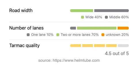
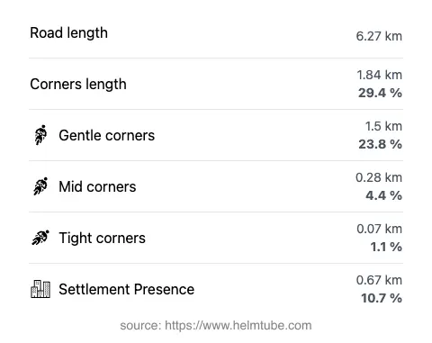
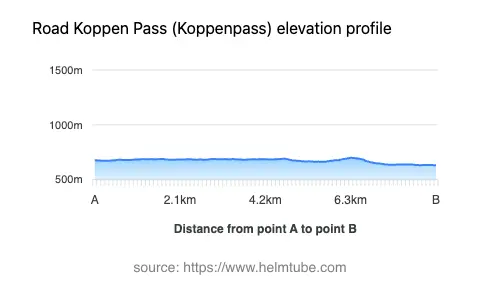
The Koppen Pass (Koppenpass) extends for approximately 6.3 km (3.9 miles), with elevations ranging from 631 m (2,070 ft) to 700 m (2,297 ft). The road surface is asphalt and is generally of high quality, rated as excellent to very good. Riders will encounter a mix of gently curved and moderately twisty sections, making it suitable for those seeking a technical but not overly demanding ride. The majority of the road (about 73%) features two lanes, with the remainder being a mix of one-lane and wider sections. Most of the route is of medium width (about 56%), with a significant portion being wide (40%), and only a small fraction considered narrow. The road passes through inhabited areas for a limited stretch (approximately 10.7%), ensuring a predominantly rural and natural riding environment. The maximum speed limit is 40 km/h (25 mph), reflecting the road’s technical nature and the need for caution in certain segments.
Natural Features: Rivers, Valleys, and Mountain Ranges
Koppen Pass (Koppenpass) is notable for its alignment along the Traun River, with about 35% of the route running adjacent to the waterway. The Traun is a significant river in Upper Austria, ultimately joining the Danube. The road’s passage through the Koppental valley (approximately 78% of its length) provides a distinctive alpine setting, with the surrounding Totes Gebirge and Dachsteingebirge mountain ranges contributing to the landscape. The broader context of the Alps further enhances the route’s appeal for riders interested in alpine environments. For more information on the Traun River, refer to Traun (river). Details about the Totes Gebirge and Dachsteingebirge can be found on Totes Gebirge and Dachstein Mountains respectively.
Road Closures and Seasonal Accessibility
Research indicates that Koppen Pass (Koppenpass) is generally open to motorcycles and other vehicles. However, due to its alpine location, the road may be subject to temporary closures during the winter months or in adverse weather conditions, such as heavy snowfall or flooding. Event-related closures are rare but may occur for maintenance or local events. Riders are advised to check current road conditions before planning a trip, especially outside the main riding season. Up-to-date information on road closures can typically be found on the ASFINAG Traffic Reports website.
Tolls, Fees, and Practical Information
Currently, there is no toll or entrance fee required to ride the Koppen Pass (Koppenpass). Riders should be aware that toll conditions may change in the future, and it is advisable to verify the latest information before travel. For comprehensive details on road tolls and entrance fees in Austria, consult the ASFINAG Toll Information page. The road’s technical profile, combined with its alpine setting, makes it a worthwhile consideration for motorcyclists seeking a blend of natural beauty and riding challenge.
Explore the Region: Roads Close By
Discover more amazing roads located near the route featured in this article. The list below highlights nearby routes that are perfect for extending your ride or planning your next adventure.
Ride the Best: Austria’s Top Motorcycle Roads
These are the best motorbiking roads in Austria. The list below shows links to articles about top-rated motorcycle routes in the country. Explore the most popular roads in Austria and plan your next unforgettable motorbike adventure.