Exploring the Gletscherstraße: A Motorcyclist’s Guide to the Grossglockner High Alpine Road
Locals know best!
If you travel this road often or live close by you will be given a chance to provide your valuable rating soon! Sign in and stay connected.Location and Alpine Setting
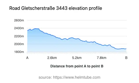
The Gletscherstraße is situated in Austria, within the state of Carinthia, and forms part of the iconic Grossglockner High Alpine Road. This stretch of road crosses the Glocknergruppe, a subrange of the Alps, and runs through the Mölltal and Guttal valleys. The region is characterized by dramatic alpine landscapes, with the road itself reaching elevations between 1,874 m (6,148 ft) and 2,389 m (7,838 ft). The Gletscherstraße is easily accessible from the broader Oberkärnten area and is a key route for those wishing to experience the Austrian Alps by motorcycle. An interactive map showing the route of the Gletscherstraße can be found at the end of this article.
Road Characteristics and Riding Experience
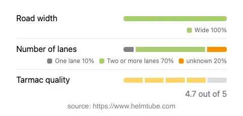
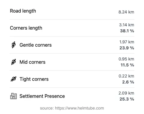
The Gletscherstraße extends for approximately 8.2 km (5.1 miles), with the majority of its length (about 90%) offering wide, two-lane asphalt surfaces. The road is moderately curvy, providing a balance between technical riding and comfortable touring. Surface quality is generally excellent, allowing for confident cornering and smooth progress. The route passes through both inhabited and uninhabited areas, with roughly a quarter of the road traversing settlements. The maximum speed limit is 70 km/h (43 mph), which is appropriate given the road’s elevation changes and the presence of multiple viewpoints. Riders will appreciate the combination of gentle curves and occasional tighter bends, making it suitable for a range of skill levels.
Scenic Attractions and Viewpoints
One of the defining features of the Gletscherstraße is its proximity to several panoramic viewpoints. These stops offer expansive views of the surrounding Alps, including the Glocknergruppe and the valleys below. The road itself is part of the larger Grossglockner High Alpine Road, which is celebrated for its dramatic scenery and access to Austria’s highest peak, the Grossglockner. Riders are encouraged to take advantage of the numerous viewpoints along the route, which provide opportunities for photography and rest. The Mölltal and Guttal valleys, both traversed by the road, add to the visual appeal and offer insight into the region’s geography.
Seasonal Access and Road Closures
The Gletscherstraße, as part of the Grossglockner High Alpine Road, is subject to seasonal closures due to snow and adverse weather conditions. Typically, the road is open from early May to late October, but exact dates can vary depending on snowfall and maintenance requirements. Motorcyclists should verify current opening times before planning a trip, as winter closures are strictly enforced for safety reasons. There are no known restrictions specific to motorcycles outside of these seasonal closures. Event-related closures are rare but may occur for maintenance or special events. For up-to-date information on road status, consult the official Grossglockner High Alpine Road website.
Tolls, Fees, and Practical Information
Access to the Gletscherstraße and the broader Grossglockner High Alpine Road is subject to a toll. The fee applies to all motor vehicles, including motorcycles, and is collected at designated toll stations. Toll rates may change, so riders are advised to check the latest prices on the official ticket and price page. It is important to note that toll conditions can change in the future. For general information about road tolls and entrance fees in Austria, visit the ASFINAG toll information page. Riders should ensure they have the necessary documentation and payment methods before embarking on their journey.
Explore the Region: Roads Close By
Discover more amazing roads located near the route featured in this article. The list below highlights nearby routes that are perfect for extending your ride or planning your next adventure.
Ride the Best: Austria’s Top Motorcycle Roads
These are the best motorbiking roads in Austria. The list below shows links to articles about top-rated motorcycle routes in the country. Explore the most popular roads in Austria and plan your next unforgettable motorbike adventure.