Exploring the Hallein–Pichl Alpine Route: A Motorcyclist’s Guide
Locals know best!
If you travel this road often or live close by you will be given a chance to provide your valuable rating soon! Sign in and stay connected.Location and Overview of the Hallein–Pichl Route
The Hallein–Pichl route is situated in the Austrian state of Salzburg, traversing the northern reaches of the Alps and the Salzkammergut-Berge. The road connects the town of Hallein, known for its salt mining heritage, with the village of Pichl. Riders will find themselves navigating through a landscape characterized by rolling alpine foothills, forested slopes, and occasional river valleys. The route’s proximity to the Aubach river and its passage through the Salzkammergut-Berge make it a compelling choice for those interested in exploring the lesser-known mountain roads of Austria. An interactive map showing the precise route can be found at the end of this article.
Road Characteristics and Riding Experience
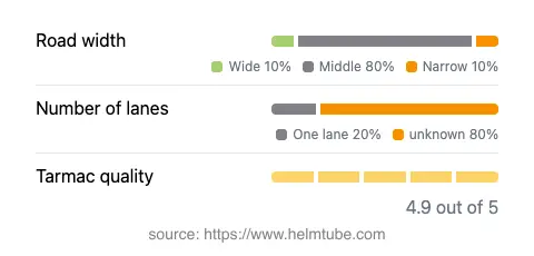
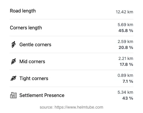
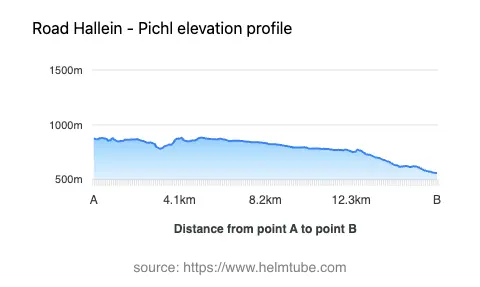
The Hallein–Pichl road extends for approximately 12.4 km (7.7 miles), offering a moderately curvy riding experience. The curves are generally gentle to moderately tight, making the road suitable for riders of varying skill levels. The surface is asphalt and is rated as excellent, providing reliable grip and comfort throughout the journey. The road width is predominantly of medium size (about 81%), with occasional narrow and wide sections. Most of the route consists of two lanes, though there are stretches with only one lane (about 24%), requiring attention when passing or encountering oncoming traffic. The elevation ranges from 560 m (1,837 ft) at its lowest point to 883 m (2,897 ft) at its highest, offering moderate altitude changes without the extreme gradients found on some alpine passes. The route passes through inhabited areas for roughly 43% of its length, providing access to local amenities and services.
Natural Features and Attractions Along the Route
One of the defining features of the Hallein–Pichl route is its alignment with the Aubach river for a significant portion of the journey. The river, a tributary of the Lammer, accompanies the road for over 8.6 km (5.3 miles), adding to the natural ambiance. The road also crosses the Salzkammergut-Berge, a subrange of the Alps known for its rugged terrain and panoramic viewpoints. Riders will encounter at least two designated viewpoints along the route, offering opportunities to pause and appreciate the surrounding alpine landscape. The proximity to the town of Hallein provides access to the historic Hallein Salt Mine, a notable attraction in the region. The Salzkammergut area itself is recognized for its lakes, mountains, and cultural heritage, making this route a gateway to further exploration.
Seasonal Accessibility and Road Regulations
The Hallein–Pichl route is generally open to motorcyclists throughout the year, though winter conditions in the Alps can lead to temporary closures or hazardous riding surfaces due to snow and ice. Riders are advised to check local traffic updates and weather forecasts before planning a trip, especially during the colder months. There are no known permanent restrictions for motorcycles on this road. Event-related closures are rare but may occur during local festivals or road maintenance periods. For up-to-date information on road conditions and closures, consult the ASFINAG Traffic Reports.
Tolls, Fees, and Additional Information
Currently, there are no tolls or entrance fees specifically required for motorcycles on the Hallein–Pichl route. However, toll conditions in Austria are subject to change, and riders should verify the latest requirements before departure. For comprehensive information on road tolls and vignettes in Austria, refer to the ASFINAG Vignette Information page. It is important to note that while this particular road does not require a vignette, many Austrian highways and expressways do. Always ensure compliance with local regulations to avoid fines.
Explore the Region: Roads Close By
Discover more amazing roads located near the route featured in this article. The list below highlights nearby routes that are perfect for extending your ride or planning your next adventure.
Ride the Best: Austria’s Top Motorcycle Roads
These are the best motorbiking roads in Austria. The list below shows links to articles about top-rated motorcycle routes in the country. Explore the most popular roads in Austria and plan your next unforgettable motorbike adventure.