Sölk Pass (Sölkpass (Erzherzog-Johann-Straße)): A Technical Overview for Motorcyclists
Locals know best!
If you travel this road often or live close by you will be given a chance to provide your valuable rating soon! Sign in and stay connected.Location and Geographic Context
Sölk Pass (Sölkpass (Erzherzog-Johann-Straße)) is situated in central Austria, within the federal state of Styria. The road connects the valleys of the Enns and Mur rivers, passing through the settlement of Sölkpaßstraße. It crosses several mountain ranges, including the Schladminger Tauern, Niedere Tauern, and the broader Alps. The route also traverses the Naturpark Sölktäler, a protected area known for its alpine landscapes and biodiversity. An interactive map showing the road’s course can be found at the end of the article.
Road Characteristics and Riding Experience
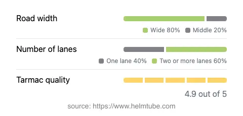
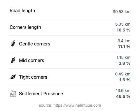
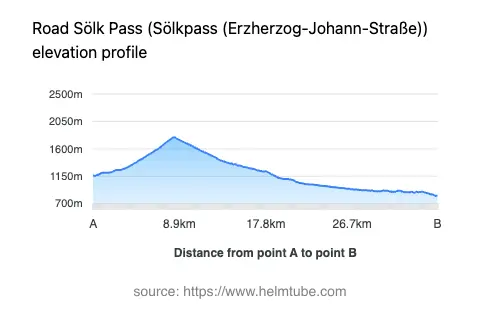
The Sölk Pass road extends for approximately 30.5 km (19 miles), with elevations ranging from 828 m (2,717 ft) at its lowest point to 1,789 m (5,869 ft) at its highest. The route is predominantly surfaced with high-quality asphalt, rated as excellent by most standards. Riders will encounter a mix of lane configurations: the majority of the road (about 60%) features two lanes, while a smaller portion (about 38%) is single-lane. The road is generally wide (about 76%), with some sections of medium width. The alignment is moderately curvy, offering a balance between gently curved and more technical segments, making it suitable for riders seeking a varied but not overly demanding experience. The maximum speed limit is 100 km/h (62 mph) in some sections, with lower limits in others. Approximately 45.5% of the route passes through inhabited areas, providing occasional access to local amenities.
Natural Features and Points of Interest
The road closely follows the course of the Großsölkbach river for much of its length (about 59%), offering views of alpine watercourses and valleys. The pass itself, Sölkpass, reaches an elevation of 1,790 m (5,873 ft) and serves as a crossing point between the Enns and Mur river basins. The surrounding Naturpark Sölktäler is a designated nature park, providing opportunities for wildlife observation and hiking. Several viewpoints are accessible along the route, allowing for panoramic views of the Schladminger Tauern and Niedere Tauern ranges. The road’s proximity to these natural features enhances its appeal for riders interested in alpine environments and outdoor activities.
Seasonal Accessibility and Road Closures
Sölk Pass is subject to seasonal closures due to snow and adverse weather conditions. Typically, the road is closed to all traffic, including motorcycles, during the winter months, often from late autumn until late spring. The exact dates of closure can vary depending on weather and maintenance schedules. There are no regular event-related closures reported, but temporary restrictions may occur due to roadworks or local events. Riders are advised to check current conditions before planning a trip. Up-to-date information on road status can be found on the ASFINAG Traffic Reports website.
Tolls, Fees, and Practical Considerations
There is currently no toll or entrance fee required to ride the Sölk Pass road. However, toll conditions may change in the future, and riders should verify the latest information before traveling. For comprehensive details on tolls and fees applicable to Austrian roads, including updates on changes, consult the ASFINAG Toll Information page. The road’s excellent surface quality and moderate traffic levels make it a practical choice for motorcyclists seeking a reliable alpine route. Facilities along the route are limited, so it is advisable to plan fuel and rest stops in advance.
Explore the Region: Roads Close By
Discover more amazing roads located near the route featured in this article. The list below highlights nearby routes that are perfect for extending your ride or planning your next adventure.
Ride the Best: Austria’s Top Motorcycle Roads
These are the best motorbiking roads in Austria. The list below shows links to articles about top-rated motorcycle routes in the country. Explore the most popular roads in Austria and plan your next unforgettable motorbike adventure.