Riding the Hochkönig Pass Route: Bischofshofen to Saalfelden am Steinernen Meer via Dientner Sattel and Filzensattel
Locals know best!
If you travel this road often or live close by you will be given a chance to provide your valuable rating soon! Sign in and stay connected.Location and Overview of the Hochkönig Pass Route
The Hochkönig Pass Route connects the town of Bischofshofen in the west to Saalfelden am Steinernen Meer in the east, situated in the Austrian state of Salzburg. The road, commonly referred to as the Hochkönig Straße (B164), is well-known among local and visiting motorcyclists for its passage through the heart of the Alps, specifically the Salzburger Schieferalpen and the Hochkönigstock mountain ranges. The route is characterized by its alpine setting, with the road climbing over two significant mountain passes: Dientner Sattel and Filzensattel. The journey offers access to several mountain valleys, including a brief section through the Salzachtal. An interactive map showing the full route and its key features can be found at the end of this article.
Road Details and Riding Experience
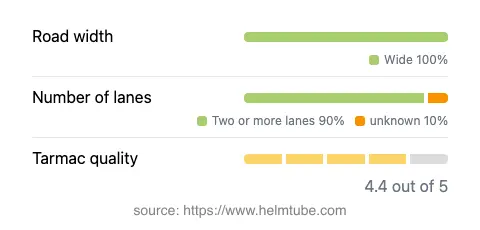
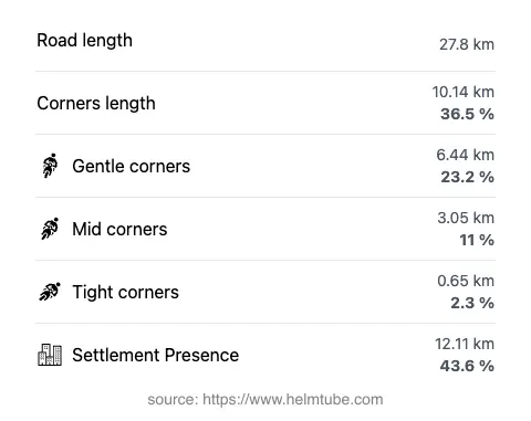
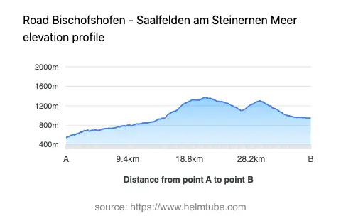
The Hochkönig Pass Route covers approximately 27.8 km (17.3 miles) of asphalt road, with the majority (about 91%) consisting of two wide lanes, providing ample space for overtaking and maneuvering. The surface quality is generally very good, offering a smooth ride with only occasional minor imperfections. The road is moderately curvy, with a mix of gently sweeping bends and some tighter turns, especially near the mountain passes. Elevation ranges from 549 m (1,801 ft) at its lowest point to 1,373 m (4,505 ft) at the highest, with the Dientner Sattel (1,370 m / 4,495 ft) and Filzensattel (1,290 m / 4,232 ft) providing the most significant climbs and descents. Speed limits vary along the route, typically ranging from 50 km/h (31 mph) in inhabited areas to 100 km/h (62 mph) on open stretches. About 44% of the road passes through inhabited areas, so riders should remain alert for local traffic and potential speed restrictions.
Mountain Passes and Surrounding Attractions
The route's defining features are the Dientner Sattel and Filzensattel mountain passes. The Dientner Sattel is a well-known crossing in the region, offering expansive views of the surrounding Hochkönig massif. The Filzensattel is slightly lower but equally notable for its alpine scenery. The road also skirts the edge of the Salzachtal valley and passes through the Salzburger Schieferalpen and Hochkönigstock mountain ranges. The towns at either end of the route, Bischofshofen and Saalfelden am Steinernen Meer, offer a range of amenities and serve as convenient bases for exploring the broader region. The area is also known for hiking, climbing, and winter sports, making it a year-round destination for outdoor enthusiasts.
Road Closures, Seasonal Access, and Toll Information
The Hochkönig Pass Route (B164) is generally open to motorcycles throughout the year, but temporary closures can occur due to snow, ice, or maintenance, particularly in winter months. Both Dientner Sattel and Filzensattel are subject to winter conditions, and closures are most likely between November and April, depending on snowfall. There are no permanent restrictions for motorcycles. The road does not currently require a toll or entrance fee for motorcycles or other vehicles. However, toll conditions may change in the future. For the most up-to-date information on road tolls and entrance fees in Austria, consult the ASFINAG toll information website. Event-related closures are rare but may occur during local cycling or running events; advance notice is typically provided by local authorities.
Planning Your Ride and Practical Considerations
When planning a ride along the Hochkönig Pass Route, it is advisable to check local weather forecasts and road conditions, especially during the shoulder seasons. The road's wide lanes and good surface make it suitable for riders of varying experience levels, but caution is advised on the mountain pass sections, where weather can change rapidly and visibility may be reduced. Fuel stations and services are available in both Bischofshofen and Saalfelden am Steinernen Meer, with limited options in between. The route is popular with both motorcyclists and tourists, so increased traffic can be expected during weekends and holidays. For those interested in extending their journey, the region offers numerous opportunities for further exploration, including the nearby Hochkönig massif and the broader Alps. An interactive map of the route is available below for detailed trip planning.
Explore the Region: Roads Close By
Discover more amazing roads located near the route featured in this article. The list below highlights nearby routes that are perfect for extending your ride or planning your next adventure.
Ride the Best: Austria’s Top Motorcycle Roads
These are the best motorbiking roads in Austria. The list below shows links to articles about top-rated motorcycle routes in the country. Explore the most popular roads in Austria and plan your next unforgettable motorbike adventure.